![](/images/other/stat-length.png)
![Tocht Stappen Bombon - Bombon - Photo](https://media.geolcdn.com/t/1900/400/ext.pjpeg?maxdim=2&url=https%3A%2F%2Fstatic1.geolcdn.com%2Fsiteimages%2Fupload%2Ffiles%2F1553511878bg_sport_marche.png)
Bombon
vitius
Gebruiker
![Lengte](/images/other/stat-length.png)
Lengte
10,8 km
![Max. hoogte](https://static1.geolcdn.com/siteimages/upload/files/1508320355ic_sort_altitude_max_24dp.png)
Max. hoogte
114 m
![Positief hoogteverschil](https://static1.geolcdn.com/siteimages/upload/files/1508320355ic_sort_den_pos_24dp.png)
Positief hoogteverschil
56 m
![Km-Effort](/images/other/stat-length.png)
Km-Effort
11,5 km
![Min. hoogte](https://static1.geolcdn.com/siteimages/upload/files/1508320355ic_sort_altitude_min_24dp.png)
Min. hoogte
88 m
![Negatief hoogteverschil](https://static1.geolcdn.com/siteimages/upload/files/1508320355ic_sort_den_neg_24dp.png)
Negatief hoogteverschil
55 m
![Boucle](https://static1.geolcdn.com/siteimages/upload/files/16400158638029165_repeat_loop_refresh_sync_direction_icon.png)
Boucle
Ja
Datum van aanmaak :
2019-05-07 16:38:59.275
Laatste wijziging :
2020-01-05 17:46:04.965
![Stappen](https://static1.geolcdn.com/sitytour/trail-icons/101.png)
--
Moeilijkheid : Gemakkelijk
![Scan deze QR-code om de tocht te openen in de SityTrail-applicatie](https://capi.geolives.com/qq0zvz2zws4bq2lad0pu/sitytour/trails/1070865/qr.png?size=200)
Gratisgps-wandelapplicatie
Over ons
Tocht Stappen van 10,8 km beschikbaar op Île-de-France, Seine-et-Marne, Bombon. Deze tocht wordt voorgesteld door vitius.
Beschrijving
Circuit de 11 km environ en boucle de BOMBON à St MERY en Seine et Marne, principalement à travers champs, donc possiblement venté.
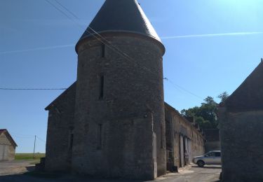
Quelques curiosités : la ferme fortifiée des Epoisses et le château de Bombon
Plaatsbepaling
Land:
France
Regio :
Île-de-France
Departement/Provincie :
Seine-et-Marne
Gemeente :
Bombon
Locatie:
Unknown
Vertrek:(Dec)
Vertrek:(UTM)
489564 ; 5380152 (31U) N.
Opmerkingen
Wandeltochten in de omgeving
![Tocht Te voet Bombon - Boucle 30 km autour de Bombon - Photo](https://media.geolcdn.com/t/375/260/3c20580b-5dc5-4b7b-ad19-7338a4cd3174.jpg&format=jpg&maxdim=2)
![Te voet Te voet](https://static1.geolcdn.com/sitytour/trail-icons/100.png)
Boucle 30 km autour de Bombon
Te voet
Medium
Bombon,
Île-de-France,
Seine-et-Marne,
France
![](/images/other/stat-length.png)
30 km | 34 km-effort
7h 42min
![](https://static1.geolcdn.com/siteimages/upload/files/16400158638029165_repeat_loop_refresh_sync_direction_icon.png)
Ja
![Tocht Stappen Saint-Méry - Boucle autour de Saint Mery 20 km - Photo](https://media.geolcdn.com/t/375/260/8aa4e70e-d8ab-4b1b-897f-cd1520e1f018.jpg&format=jpg&maxdim=2)
![Stappen Stappen](https://static1.geolcdn.com/sitytour/trail-icons/101.png)
Boucle autour de Saint Mery 20 km
Stappen
Heel gemakkelijk
Saint-Méry,
Île-de-France,
Seine-et-Marne,
France
![](/images/other/stat-length.png)
21 km | 24 km-effort
4h 53min
![](https://static1.geolcdn.com/siteimages/upload/files/16400158638029165_repeat_loop_refresh_sync_direction_icon.png)
Ja
![Tocht Stappen La Chapelle-Gauthier - Boucle La Chapelle Gauthier par François - Photo](https://media.geolcdn.com/t/375/260/e0c121e5-9a23-476f-ab87-de90523b1e27.jpg&format=jpg&maxdim=2)
![Stappen Stappen](https://static1.geolcdn.com/sitytour/trail-icons/101.png)
Boucle La Chapelle Gauthier par François
Stappen
Gemakkelijk
La Chapelle-Gauthier,
Île-de-France,
Seine-et-Marne,
France
![](/images/other/stat-length.png)
20 km | 23 km-effort
4h 35min
![](https://static1.geolcdn.com/siteimages/upload/files/16400158638029165_repeat_loop_refresh_sync_direction_icon.png)
Ja
![Tocht Stappen Bombon - Bombon 2023 - Photo](https://media.geolcdn.com/t/375/260/c3a1b84c-b69d-45b3-8086-587b8bb5cc10.jpg&format=jpg&maxdim=2)
![Stappen Stappen](https://static1.geolcdn.com/sitytour/trail-icons/101.png)
Bombon 2023
Stappen
Moeilijk
Bombon,
Île-de-France,
Seine-et-Marne,
France
![](/images/other/stat-length.png)
13,8 km | 15,5 km-effort
3h 23min
![](https://static1.geolcdn.com/siteimages/upload/files/16400158638029165_repeat_loop_refresh_sync_direction_icon.png)
Ja
![Tocht Stappen Mormant - Verneuil mormant - Photo](https://media.geolcdn.com/t/375/260/c9a15a9e-9b5c-49f8-bc1c-ad61afd6a755.jpg&format=jpg&maxdim=2)
![Stappen Stappen](https://static1.geolcdn.com/sitytour/trail-icons/101.png)
Verneuil mormant
Stappen
Medium
Mormant,
Île-de-France,
Seine-et-Marne,
France
![](/images/other/stat-length.png)
7 km | 7,4 km-effort
5h 36min
![](https://static1.geolcdn.com/siteimages/upload/files/16400158638029165_repeat_loop_refresh_sync_direction_icon.png)
Neen
![Tocht Stappen La Chapelle-Gauthier - Grand Grippon.2 - Photo](https://media.geolcdn.com/t/375/260/5cc0d26a-74ee-4ba0-bee0-7f43777f46c3.jpg&format=jpg&maxdim=2)
![Stappen Stappen](https://static1.geolcdn.com/sitytour/trail-icons/101.png)
Grand Grippon.2
Stappen
Zeer moeilijk
La Chapelle-Gauthier,
Île-de-France,
Seine-et-Marne,
France
![](/images/other/stat-length.png)
22 km | 24 km-effort
4h 48min
![](https://static1.geolcdn.com/siteimages/upload/files/16400158638029165_repeat_loop_refresh_sync_direction_icon.png)
Ja
![Tocht Stappen Saint-Ouen-en-Brie - JC 04 23 km St Ouen en Brie - Photo](https://media.geolcdn.com/t/375/260/cfb519b1-a6a9-4bde-998b-7f7d546b43ca.jpg&format=jpg&maxdim=2)
![Stappen Stappen](https://static1.geolcdn.com/sitytour/trail-icons/101.png)
JC 04 23 km St Ouen en Brie
Stappen
Moeilijk
Saint-Ouen-en-Brie,
Île-de-France,
Seine-et-Marne,
France
![](/images/other/stat-length.png)
23 km | 25 km-effort
5h 37min
![](https://static1.geolcdn.com/siteimages/upload/files/16400158638029165_repeat_loop_refresh_sync_direction_icon.png)
Ja
![Tocht Hybride fiets Champeaux - SityTrail - De Melun à Champeaux - Photo](https://media.geolcdn.com/t/375/260/2b1bb30f-5440-479e-aa11-f32d5141f790.bmp&format=jpg&maxdim=2)
![Hybride fiets Hybride fiets](https://static1.geolcdn.com/sitytour/trail-icons/203.png)
SityTrail - De Melun à Champeaux
Hybride fiets
Medium
Champeaux,
Île-de-France,
Seine-et-Marne,
France
![](/images/other/stat-length.png)
35 km | 39 km-effort
Onbekend
![](https://static1.geolcdn.com/siteimages/upload/files/16400158638029165_repeat_loop_refresh_sync_direction_icon.png)
Ja
![Tocht Hybride fiets Champeaux - SityTrail - De Melun à Champeaux - Photo](https://media.geolcdn.com/t/375/260/2b1bb30f-5440-479e-aa11-f32d5141f790.bmp&format=jpg&maxdim=2)
![Hybride fiets Hybride fiets](https://static1.geolcdn.com/sitytour/trail-icons/203.png)
SityTrail - De Melun à Champeaux
Hybride fiets
Medium
Champeaux,
Île-de-France,
Seine-et-Marne,
France
![](/images/other/stat-length.png)
36 km | 39 km-effort
Onbekend
![](https://static1.geolcdn.com/siteimages/upload/files/16400158638029165_repeat_loop_refresh_sync_direction_icon.png)
Ja