![](/images/other/stat-length.png)
![Tocht Stappen Coulon - Village de La Sèvre (pont Irleau) - Photo](https://media.geolcdn.com/t/1900/400/ext.pjpeg?maxdim=2&url=https%3A%2F%2Fstatic1.geolcdn.com%2Fsiteimages%2Fupload%2Ffiles%2F1553511878bg_sport_marche.png)
Village de La Sèvre (pont Irleau)
olaze
Gebruiker
![Lengte](/images/other/stat-length.png)
Lengte
10,5 km
![Max. hoogte](https://static1.geolcdn.com/siteimages/upload/files/1508320355ic_sort_altitude_max_24dp.png)
Max. hoogte
10 m
![Positief hoogteverschil](https://static1.geolcdn.com/siteimages/upload/files/1508320355ic_sort_den_pos_24dp.png)
Positief hoogteverschil
57 m
![Km-Effort](/images/other/stat-length.png)
Km-Effort
11,3 km
![Min. hoogte](https://static1.geolcdn.com/siteimages/upload/files/1508320355ic_sort_altitude_min_24dp.png)
Min. hoogte
0 m
![Negatief hoogteverschil](https://static1.geolcdn.com/siteimages/upload/files/1508320355ic_sort_den_neg_24dp.png)
Negatief hoogteverschil
57 m
![Boucle](https://static1.geolcdn.com/siteimages/upload/files/16400158638029165_repeat_loop_refresh_sync_direction_icon.png)
Boucle
Ja
Datum van aanmaak :
2019-01-15 18:41:36.542
Laatste wijziging :
2019-01-15 18:41:36.542
![Stappen](https://static1.geolcdn.com/sitytour/trail-icons/101.png)
2h30
Moeilijkheid : Gemakkelijk
![Scan deze QR-code om de tocht te openen in de SityTrail-applicatie](https://capi.geolives.com/qq0zvz2zws4bq2lad0pu/sitytour/trails/1069865/qr.png?size=200)
Gratisgps-wandelapplicatie
Over ons
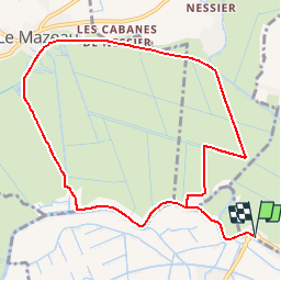
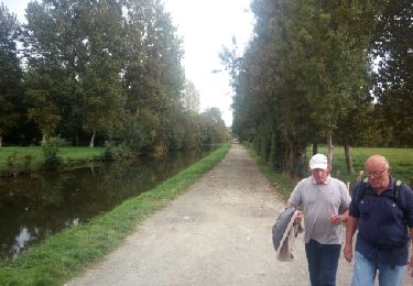
Tocht Stappen van 10,5 km beschikbaar op Nieuw-Aquitanië, Deux-Sèvres, Coulon. Deze tocht wordt voorgesteld door olaze.
Beschrijving
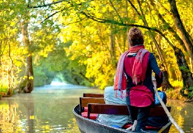
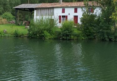
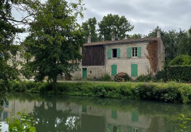
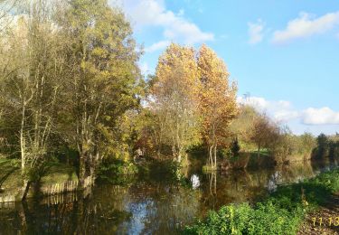
Agréable promenade dans le marais et bords de Sèvres.
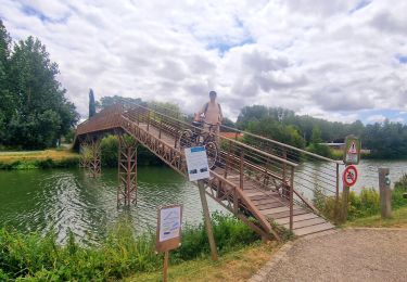
Départ et retour Pont d'Irleau.
Vers Le Village de Sèvre.
Plaatsbepaling
Land:
France
Regio :
Nieuw-Aquitanië
Departement/Provincie :
Deux-Sèvres
Gemeente :
Coulon
Locatie:
Unknown
Vertrek:(Dec)
Vertrek:(UTM)
681763 ; 5131648 (30T) N.
Opmerkingen
Wandeltochten in de omgeving
![Tocht Stappen Arçais - Arçais - Photo](https://media.geolcdn.com/t/375/260/ext.jpg?maxdim=2&url=https%3A%2F%2Fservices.sitytrail.com%2FGeolivesWS%2FDownloadMedia.ashx%3FTrailID%3D154286%26Media%3D20120918154346.jpeg)
![Stappen Stappen](https://static1.geolcdn.com/sitytour/trail-icons/101.png)
Arçais
Stappen
Gemakkelijk
(2)
Arçais,
Nieuw-Aquitanië,
Deux-Sèvres,
France
![](/images/other/stat-length.png)
9,6 km | 10,2 km-effort
2h 25min
![](https://static1.geolcdn.com/siteimages/upload/files/16400158638029165_repeat_loop_refresh_sync_direction_icon.png)
Ja
![Tocht Hybride fiets Le Mazeau - Cyclo dans le marais Poitevin - Photo](https://media.geolcdn.com/t/375/260/86905f3c-566b-4bf0-9e35-0be64feae71f.jpg&format=jpg&maxdim=2)
![Hybride fiets Hybride fiets](https://static1.geolcdn.com/sitytour/trail-icons/203.png)
Cyclo dans le marais Poitevin
Hybride fiets
Gemakkelijk
Le Mazeau,
Pays de la Loire,
Vendée,
France
![](/images/other/stat-length.png)
48 km | 51 km-effort
4h 10min
![](https://static1.geolcdn.com/siteimages/upload/files/16400158638029165_repeat_loop_refresh_sync_direction_icon.png)
Ja
![Tocht Mountainbike Sansais - La Garette - Saint Georges de Reix - Photo](https://media.geolcdn.com/t/375/260/ext.jpg?maxdim=2&url=https%3A%2F%2Fstatic1.geolcdn.com%2Fsiteimages%2Fupload%2Ffiles%2F1524743154velo.jpg)
![Mountainbike Mountainbike](https://static1.geolcdn.com/sitytour/trail-icons/202.png)
La Garette - Saint Georges de Reix
Mountainbike
Gemakkelijk
(1)
Sansais,
Nieuw-Aquitanië,
Deux-Sèvres,
France
![](/images/other/stat-length.png)
25 km | 27 km-effort
1h 50min
![](https://static1.geolcdn.com/siteimages/upload/files/16400158638029165_repeat_loop_refresh_sync_direction_icon.png)
Ja
![Tocht Mountainbike Coulon - Le Marais à VTT - Coulon - Photo](https://media.geolcdn.com/t/375/260/ext.jpg?maxdim=2&url=https%3A%2F%2Fstatic1.geolcdn.com%2Fsiteimages%2Fupload%2Ffiles%2F1524743154velo.jpg)
![Mountainbike Mountainbike](https://static1.geolcdn.com/sitytour/trail-icons/202.png)
Le Marais à VTT - Coulon
Mountainbike
Gemakkelijk
(1)
Coulon,
Nieuw-Aquitanië,
Deux-Sèvres,
France
![](/images/other/stat-length.png)
40 km | 44 km-effort
2h 0min
![](https://static1.geolcdn.com/siteimages/upload/files/16400158638029165_repeat_loop_refresh_sync_direction_icon.png)
Ja
![Tocht Stappen Le Mazeau - Mazeau_Marais_Sauvage - Photo](https://media.geolcdn.com/t/375/260/c928f69a-d8cb-467b-bfde-89b85eb625c6.jpg&format=jpg&maxdim=2)
![Stappen Stappen](https://static1.geolcdn.com/sitytour/trail-icons/101.png)
Mazeau_Marais_Sauvage
Stappen
Gemakkelijk
Le Mazeau,
Pays de la Loire,
Vendée,
France
![](/images/other/stat-length.png)
8,6 km | 9,2 km-effort
2h 45min
![](https://static1.geolcdn.com/siteimages/upload/files/16400158638029165_repeat_loop_refresh_sync_direction_icon.png)
Ja
![Tocht Elektrische fiets Coulon - Petit train de Coulon - Photo](https://media.geolcdn.com/t/375/260/f1d294eb-946d-4525-9985-772fb87c5582.jpg&format=jpg&maxdim=2)
![Elektrische fiets Elektrische fiets](https://static1.geolcdn.com/sitytour/trail-icons/205.png)
Petit train de Coulon
Elektrische fiets
Heel gemakkelijk
Coulon,
Nieuw-Aquitanië,
Deux-Sèvres,
France
![](/images/other/stat-length.png)
8,8 km | 9,3 km-effort
57min
![](https://static1.geolcdn.com/siteimages/upload/files/16400158638029165_repeat_loop_refresh_sync_direction_icon.png)
Ja
![Tocht Stappen Coulon - Magné/Coulon - Sèvre et légendes - Photo](https://media.geolcdn.com/t/375/260/4f4ff755-9590-4a76-942c-56d12a5cae9d.jpg&format=jpg&maxdim=2)
![Stappen Stappen](https://static1.geolcdn.com/sitytour/trail-icons/101.png)
Magné/Coulon - Sèvre et légendes
Stappen
Gemakkelijk
Coulon,
Nieuw-Aquitanië,
Deux-Sèvres,
France
![](/images/other/stat-length.png)
13,5 km | 14,7 km-effort
3h 48min
![](https://static1.geolcdn.com/siteimages/upload/files/16400158638029165_repeat_loop_refresh_sync_direction_icon.png)
Ja
![Tocht Stappen Coulon - Village de La Sèvre (pont Irleau)9,4km - Photo](https://media.geolcdn.com/t/375/260/fd1d97d5-7e71-4221-a960-75ca1377e151.jpg&format=jpg&maxdim=2)
![Stappen Stappen](https://static1.geolcdn.com/sitytour/trail-icons/101.png)
Village de La Sèvre (pont Irleau)9,4km
Stappen
Gemakkelijk
Coulon,
Nieuw-Aquitanië,
Deux-Sèvres,
France
![](/images/other/stat-length.png)
9,5 km | 10,1 km-effort
2h 15min
![](https://static1.geolcdn.com/siteimages/upload/files/16400158638029165_repeat_loop_refresh_sync_direction_icon.png)
Ja
![Tocht Stappen Le Mazeau - Le Mazeau 1 - Photo](https://media.geolcdn.com/t/375/260/ext.jpg?maxdim=2&url=https%3A%2F%2Fservices.sitytrail.com%2FGeolivesWS%2FDownloadMedia.ashx%3FTrailID%3D843604%26Media%3Dfix__20171010154548.jpg)
![Stappen Stappen](https://static1.geolcdn.com/sitytour/trail-icons/101.png)
Le Mazeau 1
Stappen
Gemakkelijk
Le Mazeau,
Pays de la Loire,
Vendée,
France
![](/images/other/stat-length.png)
8,6 km | 9,3 km-effort
2h 1min
![](https://static1.geolcdn.com/siteimages/upload/files/16400158638029165_repeat_loop_refresh_sync_direction_icon.png)
Ja