![](/images/other/stat-length.png)
![Tocht Stappen Malaucène - Campagne de Malaucène - Photo](https://media.geolcdn.com/t/1900/400/ext.pjpeg?maxdim=2&url=https%3A%2F%2Fstatic1.geolcdn.com%2Fsiteimages%2Fupload%2Ffiles%2F1553511878bg_sport_marche.png)
Campagne de Malaucène
tracegps
Gebruiker
![Lengte](/images/other/stat-length.png)
Lengte
6,6 km
![Max. hoogte](https://static1.geolcdn.com/siteimages/upload/files/1508320355ic_sort_altitude_max_24dp.png)
Max. hoogte
387 m
![Positief hoogteverschil](https://static1.geolcdn.com/siteimages/upload/files/1508320355ic_sort_den_pos_24dp.png)
Positief hoogteverschil
115 m
![Km-Effort](/images/other/stat-length.png)
Km-Effort
8,1 km
![Min. hoogte](https://static1.geolcdn.com/siteimages/upload/files/1508320355ic_sort_altitude_min_24dp.png)
Min. hoogte
329 m
![Negatief hoogteverschil](https://static1.geolcdn.com/siteimages/upload/files/1508320355ic_sort_den_neg_24dp.png)
Negatief hoogteverschil
115 m
![Boucle](https://static1.geolcdn.com/siteimages/upload/files/16400158638029165_repeat_loop_refresh_sync_direction_icon.png)
Boucle
Ja
Datum van aanmaak :
2014-12-10 00:00:00.0
Laatste wijziging :
2014-12-10 00:00:00.0
![Stappen](https://static1.geolcdn.com/sitytour/trail-icons/101.png)
1h30
Moeilijkheid : Gemakkelijk
![Scan deze QR-code om de tocht te openen in de SityTrail-applicatie](https://capi.geolives.com/qq0zvz2zws4bq2lad0pu/sitytour/trails/106892/qr.png?size=200)
Gratisgps-wandelapplicatie
Over ons
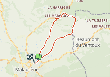
Tocht Stappen van 6,6 km beschikbaar op Provence-Alpes-Côte d'Azur, Vaucluse, Malaucène. Deze tocht wordt voorgesteld door tracegps.
Beschrijving
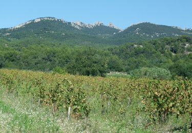
Balade au départ de Malaucène, d'après le topoguide "Pays du Ventoux", randonnée en boucle 5. Parcours très agréable parmi les arbres fruitiers (cerisiers, pêchers, abricotiers, poiriers, pruniers, etc) dans la campagne de Malaucène.
Plaatsbepaling
Land:
France
Regio :
Provence-Alpes-Côte d'Azur
Departement/Provincie :
Vaucluse
Gemeente :
Malaucène
Locatie:
Unknown
Vertrek:(Dec)
Vertrek:(UTM)
670783 ; 4893603 (31T) N.
Opmerkingen
Wandeltochten in de omgeving
![Tocht Stappen Bédoin - DEMOISELLES COIFFEES A BEDOIN - Photo](https://media.geolcdn.com/t/375/260/019fb321-209a-41dd-ae41-5842e06d9c3c.jpg&format=jpg&maxdim=2)
![Stappen Stappen](https://static1.geolcdn.com/sitytour/trail-icons/101.png)
DEMOISELLES COIFFEES A BEDOIN
Stappen
Medium
(1)
Bédoin,
Provence-Alpes-Côte d'Azur,
Vaucluse,
France
![](/images/other/stat-length.png)
18,8 km | 25 km-effort
6h 1min
![](https://static1.geolcdn.com/siteimages/upload/files/16400158638029165_repeat_loop_refresh_sync_direction_icon.png)
Ja
![Tocht Stappen Entrechaux - Entrechaux en Vaucluse - Photo](https://media.geolcdn.com/t/375/260/ext.jpg?maxdim=2&url=https%3A%2F%2Fservices.sitytrail.com%2FGeolivesWS%2FDownloadMedia.ashx%3FTrailID%3D107158%26Media%3D12001_3.jpg)
![Stappen Stappen](https://static1.geolcdn.com/sitytour/trail-icons/101.png)
Entrechaux en Vaucluse
Stappen
Medium
(1)
Entrechaux,
Provence-Alpes-Côte d'Azur,
Vaucluse,
France
![](/images/other/stat-length.png)
9,5 km | 13,7 km-effort
2h 40min
![](https://static1.geolcdn.com/siteimages/upload/files/16400158638029165_repeat_loop_refresh_sync_direction_icon.png)
Ja
![Tocht Stappen Saint-Hippolyte-le-Graveyron - Le graveron petit circuit - Photo](https://media.geolcdn.com/t/375/260/e8a95e9c-8711-4425-b0b6-166adebefe20.jpg&format=jpg&maxdim=2)
![Stappen Stappen](https://static1.geolcdn.com/sitytour/trail-icons/101.png)
Le graveron petit circuit
Stappen
Gemakkelijk
(1)
Saint-Hippolyte-le-Graveyron,
Provence-Alpes-Côte d'Azur,
Vaucluse,
France
![](/images/other/stat-length.png)
5,7 km | 8,8 km-effort
2h 5min
![](https://static1.geolcdn.com/siteimages/upload/files/16400158638029165_repeat_loop_refresh_sync_direction_icon.png)
Ja
![Tocht Stappen Le Barroux - Les Crêtes du Graveyron par l'écluse de la Falque - Photo](https://media.geolcdn.com/t/375/260/d8a64516-5e96-4aec-9024-3e89e87cb4a5.jpg&format=jpg&maxdim=2)
![Stappen Stappen](https://static1.geolcdn.com/sitytour/trail-icons/101.png)
Les Crêtes du Graveyron par l'écluse de la Falque
Stappen
Moeilijk
Le Barroux,
Provence-Alpes-Côte d'Azur,
Vaucluse,
France
![](/images/other/stat-length.png)
9 km | 13,4 km-effort
2h 57min
![](https://static1.geolcdn.com/siteimages/upload/files/16400158638029165_repeat_loop_refresh_sync_direction_icon.png)
Ja
![Tocht Stappen Bédoin - Baume du Chat final par les Siarres - Photo](https://media.geolcdn.com/t/375/260/4fd782e1-4328-4855-b0d0-bdb9d12f34a6.jpg&format=jpg&maxdim=2)
![Stappen Stappen](https://static1.geolcdn.com/sitytour/trail-icons/101.png)
Baume du Chat final par les Siarres
Stappen
Medium
Bédoin,
Provence-Alpes-Côte d'Azur,
Vaucluse,
France
![](/images/other/stat-length.png)
8,3 km | 15,6 km-effort
2h 27min
![](https://static1.geolcdn.com/siteimages/upload/files/16400158638029165_repeat_loop_refresh_sync_direction_icon.png)
Ja
![Tocht Stappen Caromb - Les 3 Termes 449 le Groseau - Photo](https://media.geolcdn.com/t/375/260/10d32099-293b-4d37-bbde-b3ecd67a6725.jpg&format=jpg&maxdim=2)
![Stappen Stappen](https://static1.geolcdn.com/sitytour/trail-icons/101.png)
Les 3 Termes 449 le Groseau
Stappen
Medium
Caromb,
Provence-Alpes-Côte d'Azur,
Vaucluse,
France
![](/images/other/stat-length.png)
11,1 km | 16,9 km-effort
2h 56min
![](https://static1.geolcdn.com/siteimages/upload/files/16400158638029165_repeat_loop_refresh_sync_direction_icon.png)
Ja
![Tocht Stappen La Roque-Alric - Rochers des Évêques - Photo](https://media.geolcdn.com/t/375/260/07ede647-be75-4726-a51b-6e74ff5b2210.jpg&format=jpg&maxdim=2)
![Stappen Stappen](https://static1.geolcdn.com/sitytour/trail-icons/101.png)
Rochers des Évêques
Stappen
Medium
La Roque-Alric,
Provence-Alpes-Côte d'Azur,
Vaucluse,
France
![](/images/other/stat-length.png)
6,7 km | 11 km-effort
2h 26min
![](https://static1.geolcdn.com/siteimages/upload/files/16400158638029165_repeat_loop_refresh_sync_direction_icon.png)
Ja
![Tocht Stappen Bédoin - P.Partie Ventoux sud - Photo](https://media.geolcdn.com/t/375/260/ext.jpg?maxdim=2&url=https%3A%2F%2Fservices.sitytrail.com%2FGeolivesWS%2FDownloadMedia.ashx%3FTrailID%3D265763%26Media%3D352fd07e-8a96-4aed-a943-ee1930eb91a7.jpg)
![Stappen Stappen](https://static1.geolcdn.com/sitytour/trail-icons/101.png)
P.Partie Ventoux sud
Stappen
Moeilijk
(1)
Bédoin,
Provence-Alpes-Côte d'Azur,
Vaucluse,
France
![](/images/other/stat-length.png)
19,3 km | 35 km-effort
5h 49min
![](https://static1.geolcdn.com/siteimages/upload/files/16400158638029165_repeat_loop_refresh_sync_direction_icon.png)
Ja
![Tocht Stappen Le Barroux - Lac du Barroux - Photo](https://media.geolcdn.com/t/375/260/ext.jpg?maxdim=2&url=https%3A%2F%2Fservices.sitytrail.com%2FGeolivesWS%2FDownloadMedia.ashx%3FTrailID%3D254117%26Media%3Dfix__20140304143604.jpg)
![Stappen Stappen](https://static1.geolcdn.com/sitytour/trail-icons/101.png)
Lac du Barroux
Stappen
Heel gemakkelijk
(2)
Le Barroux,
Provence-Alpes-Côte d'Azur,
Vaucluse,
France
![](/images/other/stat-length.png)
5,8 km | 8 km-effort
1h 42min
![](https://static1.geolcdn.com/siteimages/upload/files/16400158638029165_repeat_loop_refresh_sync_direction_icon.png)
Ja
Merci !