![](/images/other/stat-length.png)
![Tocht Mountainbike Denain - Circuit familial en direction de la Trouée d'Arenberg - Denain - Photo](https://media.geolcdn.com/t/1900/400/ext.pjpeg?maxdim=2&url=https%3A%2F%2Fstatic1.geolcdn.com%2Fsiteimages%2Fupload%2Ffiles%2F1524743154velo.jpg)
Circuit familial en direction de la Trouée d'Arenberg - Denain
tracegps
Gebruiker
![Lengte](/images/other/stat-length.png)
Lengte
26 km
![Max. hoogte](https://static1.geolcdn.com/siteimages/upload/files/1508320355ic_sort_altitude_max_24dp.png)
Max. hoogte
46 m
![Positief hoogteverschil](https://static1.geolcdn.com/siteimages/upload/files/1508320355ic_sort_den_pos_24dp.png)
Positief hoogteverschil
173 m
![Km-Effort](/images/other/stat-length.png)
Km-Effort
28 km
![Min. hoogte](https://static1.geolcdn.com/siteimages/upload/files/1508320355ic_sort_altitude_min_24dp.png)
Min. hoogte
18 m
![Negatief hoogteverschil](https://static1.geolcdn.com/siteimages/upload/files/1508320355ic_sort_den_neg_24dp.png)
Negatief hoogteverschil
173 m
![Boucle](https://static1.geolcdn.com/siteimages/upload/files/16400158638029165_repeat_loop_refresh_sync_direction_icon.png)
Boucle
Neen
Datum van aanmaak :
2014-12-10 00:00:00.0
Laatste wijziging :
2014-12-10 00:00:00.0
![Mountainbike](https://static1.geolcdn.com/sitytour/trail-icons/202.png)
2h00
Moeilijkheid : Medium
![Scan deze QR-code om de tocht te openen in de SityTrail-applicatie](https://capi.geolives.com/qq0zvz2zws4bq2lad0pu/sitytour/trails/106817/qr.png?size=200)
Gratisgps-wandelapplicatie
Over ons
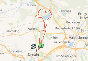
Tocht Mountainbike van 26 km beschikbaar op Hauts-de-France, Noorderdepartement, Denain. Deze tocht wordt voorgesteld door tracegps.
Beschrijving
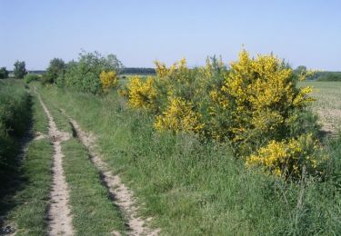
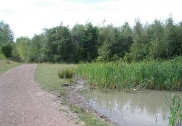
Circuit familial au départ du cimetière de Denain, direction la Trouée d'Arenberg, peu de partie à forte circulation. Il faut compter 2h avec des enfants.
Plaatsbepaling
Land:
France
Regio :
Hauts-de-France
Departement/Provincie :
Noorderdepartement
Gemeente :
Denain
Locatie:
Unknown
Vertrek:(Dec)
Vertrek:(UTM)
528987 ; 5575879 (31U) N.
Opmerkingen
Wandeltochten in de omgeving
![Tocht Mountainbike Wavrechain-sous-Denain - Direction Le Quesnoy - Denain - Photo](https://media.geolcdn.com/t/375/260/ext.jpg?maxdim=2&url=https%3A%2F%2Fstatic1.geolcdn.com%2Fsiteimages%2Fupload%2Ffiles%2F1524743154velo.jpg)
![Mountainbike Mountainbike](https://static1.geolcdn.com/sitytour/trail-icons/202.png)
Direction Le Quesnoy - Denain
Mountainbike
Medium
(1)
Wavrechain-sous-Denain,
Hauts-de-France,
Noorderdepartement,
France
![](/images/other/stat-length.png)
63 km | 70 km-effort
3h 0min
![](https://static1.geolcdn.com/siteimages/upload/files/16400158638029165_repeat_loop_refresh_sync_direction_icon.png)
Ja
![Tocht Stappen Haveluy - les pavés Bernard Hinault et pont femme à barbe - Photo](https://media.geolcdn.com/t/375/260/30f93038-ad16-4382-a628-c3d075d4266b.jpg&format=jpg&maxdim=2)
![Stappen Stappen](https://static1.geolcdn.com/sitytour/trail-icons/101.png)
les pavés Bernard Hinault et pont femme à barbe
Stappen
Gemakkelijk
Haveluy,
Hauts-de-France,
Noorderdepartement,
France
![](/images/other/stat-length.png)
9,4 km | 10,1 km-effort
2h 0min
![](https://static1.geolcdn.com/siteimages/upload/files/16400158638029165_repeat_loop_refresh_sync_direction_icon.png)
Ja
![Tocht Stappen Hérin - Hérin, variante des 4 clochers - Photo](https://media.geolcdn.com/t/375/260/ext.jpg?maxdim=2&url=https%3A%2F%2Fservices.sitytrail.com%2FGeolivesWS%2FDownloadMedia.ashx%3FTrailID%3D612067%26Media%3Dfix__20160809154447.jpg)
![Stappen Stappen](https://static1.geolcdn.com/sitytour/trail-icons/101.png)
Hérin, variante des 4 clochers
Stappen
Gemakkelijk
Hérin,
Hauts-de-France,
Noorderdepartement,
France
![](/images/other/stat-length.png)
8,7 km | 9,2 km-effort
1h 58min
![](https://static1.geolcdn.com/siteimages/upload/files/16400158638029165_repeat_loop_refresh_sync_direction_icon.png)
Ja
![Tocht Mountainbike Wavrechain-sous-Denain - Entre les canaux de la Scarpe et l'Escaut - Wavrechain-sous-Denain - Photo](https://media.geolcdn.com/t/375/260/ext.jpg?maxdim=2&url=https%3A%2F%2Fservices.sitytrail.com%2FGeolivesWS%2FDownloadMedia.ashx%3FTrailID%3D172820%26Media%3D14254_4.jpg)
![Mountainbike Mountainbike](https://static1.geolcdn.com/sitytour/trail-icons/202.png)
Entre les canaux de la Scarpe et l'Escaut - Wavrechain-sous-Denain
Mountainbike
Medium
Wavrechain-sous-Denain,
Hauts-de-France,
Noorderdepartement,
France
![](/images/other/stat-length.png)
53 km | 57 km-effort
2h 30min
![](https://static1.geolcdn.com/siteimages/upload/files/16400158638029165_repeat_loop_refresh_sync_direction_icon.png)
Ja
![Tocht Mountainbike Bellaing - Circuit de la Folle Emprise - Bellaing - Photo](https://media.geolcdn.com/t/375/260/ext.jpg?maxdim=2&url=https%3A%2F%2Fservices.sitytrail.com%2FGeolivesWS%2FDownloadMedia.ashx%3FTrailID%3D111874%26Media%3D8714_6.jpg)
![Mountainbike Mountainbike](https://static1.geolcdn.com/sitytour/trail-icons/202.png)
Circuit de la Folle Emprise - Bellaing
Mountainbike
Medium
Bellaing,
Hauts-de-France,
Noorderdepartement,
France
![](/images/other/stat-length.png)
11,3 km | 12,1 km-effort
1h 0min
![](https://static1.geolcdn.com/siteimages/upload/files/16400158638029165_repeat_loop_refresh_sync_direction_icon.png)
Ja
![Tocht Stappen Bellaing - Circuit de la Folle Emprise - Bellaing - Photo](https://media.geolcdn.com/t/375/260/ext.jpg?maxdim=2&url=https%3A%2F%2Fservices.sitytrail.com%2FGeolivesWS%2FDownloadMedia.ashx%3FTrailID%3D111873%26Media%3D8714_6.jpg)
![Stappen Stappen](https://static1.geolcdn.com/sitytour/trail-icons/101.png)
Circuit de la Folle Emprise - Bellaing
Stappen
Medium
(1)
Bellaing,
Hauts-de-France,
Noorderdepartement,
France
![](/images/other/stat-length.png)
11,3 km | 12,1 km-effort
2h 49min
![](https://static1.geolcdn.com/siteimages/upload/files/16400158638029165_repeat_loop_refresh_sync_direction_icon.png)
Ja
![Tocht Stappen Escaudain - Circuit des anciennes Carrières et du vieil Escaudain - Escaudain - Photo](https://media.geolcdn.com/t/375/260/ext.jpg?maxdim=2&url=https%3A%2F%2Fservices.sitytrail.com%2FGeolivesWS%2FDownloadMedia.ashx%3FTrailID%3D110481%26Media%3D5997_5.jpg)
![Stappen Stappen](https://static1.geolcdn.com/sitytour/trail-icons/101.png)
Circuit des anciennes Carrières et du vieil Escaudain - Escaudain
Stappen
Medium
(1)
Escaudain,
Hauts-de-France,
Noorderdepartement,
France
![](/images/other/stat-length.png)
9,9 km | 10,6 km-effort
2h 30min
![](https://static1.geolcdn.com/siteimages/upload/files/16400158638029165_repeat_loop_refresh_sync_direction_icon.png)
Ja
![Tocht Stappen Hornaing - Circuit des 3 clochers - Hornaing - Photo](https://media.geolcdn.com/t/375/260/ext.jpg?maxdim=2&url=https%3A%2F%2Fservices.sitytrail.com%2FGeolivesWS%2FDownloadMedia.ashx%3FTrailID%3D110445%26Media%3D5928_6.jpg)
![Stappen Stappen](https://static1.geolcdn.com/sitytour/trail-icons/101.png)
Circuit des 3 clochers - Hornaing
Stappen
Medium
Hornaing,
Hauts-de-France,
Noorderdepartement,
France
![](/images/other/stat-length.png)
12,1 km | 12,8 km-effort
3h 0min
![](https://static1.geolcdn.com/siteimages/upload/files/16400158638029165_repeat_loop_refresh_sync_direction_icon.png)
Ja
![Tocht Stappen Aubry-du-Hainaut - boucle 7 numerisee - Photo](https://media.geolcdn.com/t/375/260/3e03910a-92a1-439f-b531-f0d0051e08c6.jpg&format=jpg&maxdim=2)
![Stappen Stappen](https://static1.geolcdn.com/sitytour/trail-icons/101.png)
boucle 7 numerisee
Stappen
Heel gemakkelijk
Aubry-du-Hainaut,
Hauts-de-France,
Noorderdepartement,
France
![](/images/other/stat-length.png)
13,7 km | 14,8 km-effort
4h 21min
![](https://static1.geolcdn.com/siteimages/upload/files/16400158638029165_repeat_loop_refresh_sync_direction_icon.png)
Neen