![](/images/other/stat-length.png)
![Tocht Mountainbike Égliseneuve-d'Entraigues - Espace VTT FFC du Sancy - Circuit n°14 - Les Granjounes - Secteur Egliseneuve d'Entraigues - Photo](https://media.geolcdn.com/t/1900/400/ext.pjpeg?maxdim=2&url=https%3A%2F%2Fservices.sitytrail.com%2FGeolivesWS%2FDownloadMedia.ashx%3FTrailID%3D106758%26Media%3D11425_3.jpg)
Espace VTT FFC du Sancy - Circuit n°14 - Les Granjounes - Secteur Egliseneuve d'Entraigues
tracegps
Gebruiker
![Lengte](/images/other/stat-length.png)
![Max. hoogte](https://static1.geolcdn.com/siteimages/upload/files/1508320355ic_sort_altitude_max_24dp.png)
![Positief hoogteverschil](https://static1.geolcdn.com/siteimages/upload/files/1508320355ic_sort_den_pos_24dp.png)
![Km-Effort](/images/other/stat-length.png)
![Min. hoogte](https://static1.geolcdn.com/siteimages/upload/files/1508320355ic_sort_altitude_min_24dp.png)
![Negatief hoogteverschil](https://static1.geolcdn.com/siteimages/upload/files/1508320355ic_sort_den_neg_24dp.png)
![Boucle](https://static1.geolcdn.com/siteimages/upload/files/16400158638029165_repeat_loop_refresh_sync_direction_icon.png)
![Mountainbike](https://static1.geolcdn.com/sitytour/trail-icons/202.png)
49m
Moeilijkheid : Moeilijk
![Scan deze QR-code om de tocht te openen in de SityTrail-applicatie](https://capi.geolives.com/qq0zvz2zws4bq2lad0pu/sitytour/trails/106758/qr.png?size=200)
Gratisgps-wandelapplicatie
Over ons
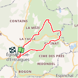
Tocht Mountainbike van 12,1 km beschikbaar op Auvergne-Rhône-Alpes, Puy-de-Dôme, Égliseneuve-d'Entraigues. Deze tocht wordt voorgesteld door tracegps.
Beschrijving
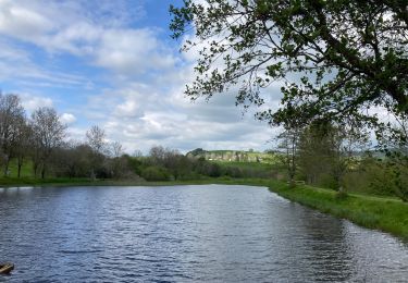
Espace VTT FFC du Sancy - Circuit n°14 - Les Granjounes - Secteur Egliseneuve d'Entraigues Circuit officiel labellisé par la Fédération Française de Cyclisme. Départ au Gîte d’étape des Rivaux. Un itinéraire accidenté pour sportifs, au pays « d’entre les eaux » et en bordure nord du plateau du Cézallier.
Plaatsbepaling
Opmerkingen
Wandeltochten in de omgeving
![Tocht Mountainbike Égliseneuve-d'Entraigues - Espace VTT FFC du Sancy - Circuit n°13 - La Chaux - Secteur Egliseneuve d'Entraigues - Photo](https://media.geolcdn.com/t/375/260/ext.jpg?maxdim=2&url=https%3A%2F%2Fservices.sitytrail.com%2FGeolivesWS%2FDownloadMedia.ashx%3FTrailID%3D106757%26Media%3D11424_2.jpg)
![Mountainbike Mountainbike](https://static1.geolcdn.com/sitytour/trail-icons/202.png)
Mountainbike
![](/images/other/stat-length.png)
![](https://static1.geolcdn.com/siteimages/upload/files/16400158638029165_repeat_loop_refresh_sync_direction_icon.png)
![Tocht Te voet Égliseneuve-d'Entraigues - Aulnay - Photo](https://media.geolcdn.com/t/375/260/b29b9335-03fb-40ee-b496-851e91bece85.jpeg&format=jpg&maxdim=2)
![Te voet Te voet](https://static1.geolcdn.com/sitytour/trail-icons/100.png)
Te voet
![](/images/other/stat-length.png)
![](https://static1.geolcdn.com/siteimages/upload/files/16400158638029165_repeat_loop_refresh_sync_direction_icon.png)
![Tocht Te voet Égliseneuve-d'Entraigues - La visade - Photo](https://media.geolcdn.com/t/375/260/b29b9335-03fb-40ee-b496-851e91bece85.jpeg&format=jpg&maxdim=2)
![Te voet Te voet](https://static1.geolcdn.com/sitytour/trail-icons/100.png)
Te voet
![](/images/other/stat-length.png)
![](https://static1.geolcdn.com/siteimages/upload/files/16400158638029165_repeat_loop_refresh_sync_direction_icon.png)
![Tocht Te voet Espinchal - Le Bois de Play - Photo](https://media.geolcdn.com/t/375/260/9599b8e6-5ea9-47d4-b175-142e2bc24cd5.jpeg&format=jpg&maxdim=2)
![Te voet Te voet](https://static1.geolcdn.com/sitytour/trail-icons/100.png)
Te voet
![](/images/other/stat-length.png)
![](https://static1.geolcdn.com/siteimages/upload/files/16400158638029165_repeat_loop_refresh_sync_direction_icon.png)
![Tocht Te voet Égliseneuve-d'Entraigues - La cime des pres - Photo](https://media.geolcdn.com/t/375/260/2f1290cf-e7a6-4663-8ec6-3697089cc854.jpeg&format=jpg&maxdim=2)
![Te voet Te voet](https://static1.geolcdn.com/sitytour/trail-icons/100.png)
Te voet
![](/images/other/stat-length.png)
![](https://static1.geolcdn.com/siteimages/upload/files/16400158638029165_repeat_loop_refresh_sync_direction_icon.png)
![Tocht Te voet Égliseneuve-d'Entraigues - Bogon - Photo](https://media.geolcdn.com/t/375/260/9cd056e6-e5cc-4cac-ae56-b755de736eab.jpeg&format=jpg&maxdim=2)
![Te voet Te voet](https://static1.geolcdn.com/sitytour/trail-icons/100.png)
Te voet
![](/images/other/stat-length.png)
![](https://static1.geolcdn.com/siteimages/upload/files/16400158638029165_repeat_loop_refresh_sync_direction_icon.png)
![Tocht Te voet Égliseneuve-d'Entraigues - Auger - Photo](https://media.geolcdn.com/t/375/260/9cd056e6-e5cc-4cac-ae56-b755de736eab.jpeg&format=jpg&maxdim=2)
![Te voet Te voet](https://static1.geolcdn.com/sitytour/trail-icons/100.png)
Te voet
![](/images/other/stat-length.png)
![](https://static1.geolcdn.com/siteimages/upload/files/16400158638029165_repeat_loop_refresh_sync_direction_icon.png)
![Tocht Te voet Picherande - Le Lac Chauvet - Photo](https://media.geolcdn.com/t/375/260/0a06c9c2-0789-44b7-b2be-bed9042bb6fe.jpeg&format=jpg&maxdim=2)
![Te voet Te voet](https://static1.geolcdn.com/sitytour/trail-icons/100.png)
Te voet
![](/images/other/stat-length.png)
![](https://static1.geolcdn.com/siteimages/upload/files/16400158638029165_repeat_loop_refresh_sync_direction_icon.png)
![Tocht Stappen Égliseneuve-d'Entraigues - Boucle Egliseneuve d’Entraigue - les cascades - Photo](https://media.geolcdn.com/t/375/260/13e9c10c-5370-47e0-843e-54694937f120.jpg&format=jpg&maxdim=2)
![Stappen Stappen](https://static1.geolcdn.com/sitytour/trail-icons/101.png)
Stappen
![](/images/other/stat-length.png)
![](https://static1.geolcdn.com/siteimages/upload/files/16400158638029165_repeat_loop_refresh_sync_direction_icon.png)