Tocht Mountainbike La Vespière-Friardel - Randonnée VTT La Vespière 32 Kms 22-05-2011 - Photo

Randonnée VTT La Vespière 32 Kms 22-05-2011

 tracegps
tracegps

Gebruiker

© OpenStreetMap contributors
Lengte
Lengte
33 km
Max. hoogte
Max. hoogte
215 m
Positief hoogteverschil
546 m
Km-Effort
Km-Effort  
40 km
Min. hoogte
Min. hoogte
112 m
Negatief hoogteverschil
550 m
Boucle
Boucle
Ja
Datum van aanmaak :
2014-12-10 00:00:00.0
Laatste wijziging :
2014-12-10 00:00:00.0

(0 Bericht)

Mountainbike
Mountainbike
2h00
Moeilijkheid : Medium

Scan deze QR-code om de tocht te openen in de SityTrail-applicatie

Gratisgps-wandelapplicatie

Logo SityTrail SityTrail

IGN / Geografische instituten

SityTrail uit de App Store downloaden SityTrail uit Google Play downloaden

Logo SityTrail SityTrail World

De wereld gaat voor u open

SityTrail uit de App Store downloaden SityTrail uit Google Play downloaden SityTrail op Huawei AppGallery downloaden

Over ons

Tocht Mountainbike van 33 km beschikbaar op Normandië, Calvados, La Vespière-Friardel. Deze tocht wordt voorgesteld door tracegps.

Beschrijving

Randonnée VTT de La Vespière du 22 mai 2011 32 Km. Départ parking de la mairie pour une belle randonnée avec beaucoup de Forets, passage par la Foletière Abenon, Saint Aubin de Bonneval et par Friardel. A noter aussi un très beau passage auprès d'un cressonnière. De belles descentes à fond la caisse (attention tout de même) et donc de belle montées avec environ 600 Mètres. Bonne et belle randonnée.

Hoogteprofiel

POI's

POI La Vespière-Friardel - Randonn?e VTT La Vespiere 32 Kms 22-05-2011 32.653  - Photo
tracegps
LA VESPIÈRE-FRIARDEL 

Plaatsbepaling

Land:
France
Regio :
Normandië
Departement/Provincie :
Calvados
Gemeente :
La Vespière-Friardel
Locatie:
Unknown
Vertrek:(Dec)
Vertrek:(UTM)
310833 ; 5432728 (31U) N.

Wandeltochten in de omgeving

Tocht Fiets Saint-Germain-la-Campagne - Boucle des maisons de maîtres  -  St-Germain la Campagne - Photo
Fiets
tracegps

Fiets

Medium
(1)
Saint-Germain-la-Campagne, Normandië, Eure, France
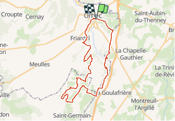
16,3 km | 17,4 km-effort
1h 0min
Ja
Tocht Stappen Saint-Martin-de-Bienfaite-la-Cressonnière - saint Martin de bienfaite la cressonnière - Photo
Stappen
werth

Stappen

Medium
Saint-Martin-de-Bienfaite-la-Cressonnière, Normandië, Calvados, France
9,6 km | 12,2 km-effort
2h 52min
Ja
Tocht Stappen Livarot-Pays-d'Auge - Cerqueux  - Photo
Stappen
Eve - Line

Stappen

Gemakkelijk
Livarot-Pays-d'Auge, Normandië, Calvados, France
8,2 km | 9,1 km-effort
2h 8min
Ja
Tocht Stappen Saint-Germain-la-Campagne - Chemin du Sabot bis - Photo
Stappen
FROIDMONT

Stappen

Gemakkelijk
(1)
Saint-Germain-la-Campagne, Normandië, Eure, France
9,8 km | 11,2 km-effort
2h 34min
Ja
Tocht Stappen La Chapelle-Gauthier - La Mare Péreuse - La Chapelle-Gauthier - Photo
Stappen
tracegps

Stappen

Medium
La Chapelle-Gauthier, Normandië, Eure, France
10,3 km | 11,9 km-effort
2h 45min
Ja
Tocht Stappen Livarot-Pays-d'Auge - Cerqueux (14) - Photo
Stappen
Eve - Line

Stappen

Medium
Livarot-Pays-d'Auge, Normandië, Calvados, France
15,8 km | 18,1 km-effort
3h 43min
Ja
Tocht Stappen Saint-Germain-la-Campagne - st Germain le campagne  - Photo
Stappen
ymarvin

Stappen

Gemakkelijk
Saint-Germain-la-Campagne, Normandië, Eure, France
8,3 km | 9,3 km-effort
1h 40min
Ja
Tocht Stappen La Vespière-Friardel - La Vespiere  - Photo
Stappen
Eve - Line

Stappen

Medium
La Vespière-Friardel, Normandië, Calvados, France
22 km | 27 km-effort
4h 22min
Ja
Tocht Stappen Saint-Germain-la-Campagne - Chemin du Sabot - St Germain la Campagne - Photo
Stappen
tracegps

Stappen

Medium
Saint-Germain-la-Campagne, Normandië, Eure, France
8,6 km | 9,2 km-effort
2h 10min
Ja


Sluiten
Mijn abonnementen