![](/images/other/stat-length.png)
![Tocht Stappen Cubières-sur-Cinoble - Sentier Cathare - De Cubières à Duilhac sous Peyrepertuse - Photo](https://media.geolcdn.com/t/1900/400/ext.pjpeg?maxdim=2&url=https%3A%2F%2Fservices.sitytrail.com%2FGeolivesWS%2FDownloadMedia.ashx%3FTrailID%3D106638%26Media%3D11248_6.jpg)
Sentier Cathare - De Cubières à Duilhac sous Peyrepertuse
tracegps
Gebruiker
![Lengte](/images/other/stat-length.png)
![Max. hoogte](https://static1.geolcdn.com/siteimages/upload/files/1508320355ic_sort_altitude_max_24dp.png)
![Positief hoogteverschil](https://static1.geolcdn.com/siteimages/upload/files/1508320355ic_sort_den_pos_24dp.png)
![Km-Effort](/images/other/stat-length.png)
![Min. hoogte](https://static1.geolcdn.com/siteimages/upload/files/1508320355ic_sort_altitude_min_24dp.png)
![Negatief hoogteverschil](https://static1.geolcdn.com/siteimages/upload/files/1508320355ic_sort_den_neg_24dp.png)
![Boucle](https://static1.geolcdn.com/siteimages/upload/files/16400158638029165_repeat_loop_refresh_sync_direction_icon.png)
![Stappen](https://static1.geolcdn.com/sitytour/trail-icons/101.png)
6h30
Moeilijkheid : Moeilijk
![Scan deze QR-code om de tocht te openen in de SityTrail-applicatie](https://capi.geolives.com/qq0zvz2zws4bq2lad0pu/sitytour/trails/106638/qr.png?size=200)
Gratisgps-wandelapplicatie
Over ons
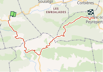
Tocht Stappen van 16,1 km beschikbaar op Occitanië, Aude, Cubières-sur-Cinoble. Deze tocht wordt voorgesteld door tracegps.
Beschrijving
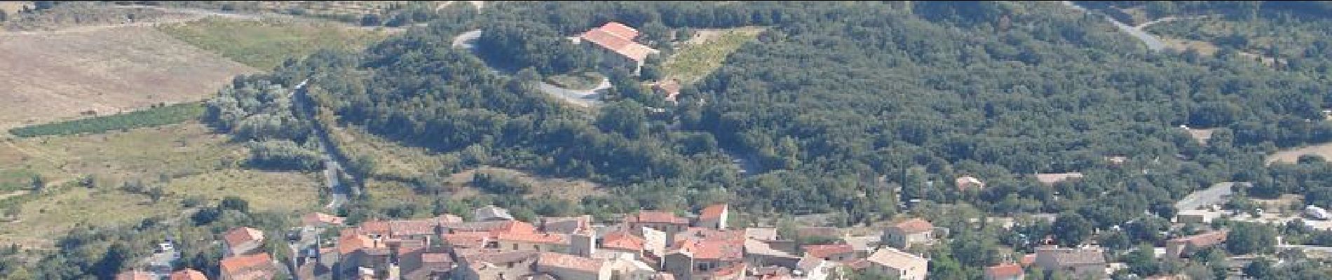
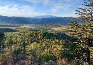
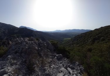
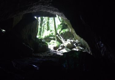
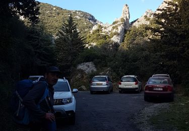
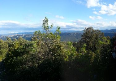
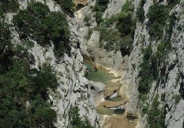
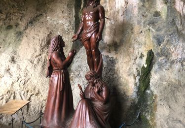
Étape 7-18 km-600 m dénivelé C'est une façon personnelle de faire le sentier pour découvrir un joyau local, les Gorges de Galamus. Partir du Cubières par la route et traverser les gorges de bon matin, avant la circulation et les touristes. C'est splendide ! Au bout des gorges descendre sur la droite avant le tunnel routier sur le sentier qui amène au tunnel piétons de l'Ermitage Saint Antoine de Galamus ( voir sur internet), splendide visite. Remonter au parking et continuer sur la route pour reprendre le sentier sur la gauche. Vous changerez de départements 2 fois: Aude -PO et PO - Aude. Belles vues sur la Fenouillède et ensuite sur le château de Peyreperthuse. Monter au château pour la visite si le temps vous le permet. Ensuite descendre au village et le visiter. Passer voir la fontaine !
Plaatsbepaling
Opmerkingen
Wandeltochten in de omgeving
![Tocht Stappen Saint-Paul-de-Fenouillet - Ermitage de Galamus - Photo](https://media.geolcdn.com/t/375/260/46039162-6164-4640-a304-ccd455d5027d.jpg&format=jpg&maxdim=2)
![Stappen Stappen](https://static1.geolcdn.com/sitytour/trail-icons/101.png)
Stappen
![](/images/other/stat-length.png)
![](https://static1.geolcdn.com/siteimages/upload/files/16400158638029165_repeat_loop_refresh_sync_direction_icon.png)
![Tocht Stappen Saint-Paul-de-Fenouillet - La Quille - Photo](https://media.geolcdn.com/t/375/260/47f7336c-3219-4083-bfb3-c8b198d14d48.jpg&format=jpg&maxdim=2)
![Stappen Stappen](https://static1.geolcdn.com/sitytour/trail-icons/101.png)
Stappen
![](/images/other/stat-length.png)
![](https://static1.geolcdn.com/siteimages/upload/files/16400158638029165_repeat_loop_refresh_sync_direction_icon.png)
![Tocht Stappen Saint-Paul-de-Fenouillet - Autour des gorges de Galamus - Photo](https://media.geolcdn.com/t/375/260/ebb1bc80-1a1f-4b07-90dd-5976415c2a9f.jpg&format=jpg&maxdim=2)
![Stappen Stappen](https://static1.geolcdn.com/sitytour/trail-icons/101.png)
Stappen
![](/images/other/stat-length.png)
![](https://static1.geolcdn.com/siteimages/upload/files/16400158638029165_repeat_loop_refresh_sync_direction_icon.png)
![Tocht Stappen Prugnanes - roc paradet - Photo](https://media.geolcdn.com/t/375/260/f4e6fd12-f0ab-4601-9b76-44d15e72f3de.jpg&format=jpg&maxdim=2)
![Stappen Stappen](https://static1.geolcdn.com/sitytour/trail-icons/101.png)
Stappen
![](/images/other/stat-length.png)
![](https://static1.geolcdn.com/siteimages/upload/files/16400158638029165_repeat_loop_refresh_sync_direction_icon.png)
![Tocht Stappen Saint-Paul-de-Fenouillet - st Paul de fenouinlet / col lenty et retour - Photo](https://media.geolcdn.com/t/375/260/281156ab-3036-4fe8-93da-4a2eaadc40df.jpg&format=jpg&maxdim=2)
![Stappen Stappen](https://static1.geolcdn.com/sitytour/trail-icons/101.png)
Stappen
![](/images/other/stat-length.png)
![](https://static1.geolcdn.com/siteimages/upload/files/16400158638029165_repeat_loop_refresh_sync_direction_icon.png)
![Tocht Stappen Prugnanes - Prugnanes Roc Paradet - Photo](https://media.geolcdn.com/t/375/260/ext.jpg?maxdim=2&url=https%3A%2F%2Fservices.sitytrail.com%2FGeolivesWS%2FDownloadMedia.ashx%3FTrailID%3D327912%26Media%3Dfix__20140723095802.jpg)
![Stappen Stappen](https://static1.geolcdn.com/sitytour/trail-icons/101.png)
Stappen
![](/images/other/stat-length.png)
![](https://static1.geolcdn.com/siteimages/upload/files/16400158638029165_repeat_loop_refresh_sync_direction_icon.png)
![Tocht Stappen Saint-Paul-de-Fenouillet - Gorges galamus-Nissol_T - Photo](https://media.geolcdn.com/t/375/260/ext.jpg?maxdim=2&url=https%3A%2F%2Fservices.sitytrail.com%2FGeolivesWS%2FDownloadMedia.ashx%3FTrailID%3D306372%26Media%3Da7076bb5-3bf2-4c5a-a4d8-4346c03497ec.jpg)
![Stappen Stappen](https://static1.geolcdn.com/sitytour/trail-icons/101.png)
Stappen
![](/images/other/stat-length.png)
![](https://static1.geolcdn.com/siteimages/upload/files/16400158638029165_repeat_loop_refresh_sync_direction_icon.png)
![Tocht Stappen Camps-sur-l'Agly - Gorges de Galamus par Nissol - Photo](https://media.geolcdn.com/t/375/260/ext.jpg?maxdim=2&url=https%3A%2F%2Fservices.sitytrail.com%2FGeolivesWS%2FDownloadMedia.ashx%3FTrailID%3D103554%26Media%3D5803_6.jpg)
![Stappen Stappen](https://static1.geolcdn.com/sitytour/trail-icons/101.png)
Stappen
![](/images/other/stat-length.png)
![](https://static1.geolcdn.com/siteimages/upload/files/16400158638029165_repeat_loop_refresh_sync_direction_icon.png)
![Tocht Stappen Saint-Paul-de-Fenouillet - Gorges galamus - Photo](https://media.geolcdn.com/t/375/260/bcffc5c8-a228-45e3-afaa-dce84f23c131.jpg&format=jpg&maxdim=2)
![Stappen Stappen](https://static1.geolcdn.com/sitytour/trail-icons/101.png)
Stappen
![](/images/other/stat-length.png)
![](https://static1.geolcdn.com/siteimages/upload/files/16400158638029165_repeat_loop_refresh_sync_direction_icon.png)