![](/images/other/stat-length.png)
![Tocht Stappen Labruyère - Marche à Labruyere - Photo](https://media.geolcdn.com/t/1900/400/ext.pjpeg?maxdim=2&url=https%3A%2F%2Fstatic1.geolcdn.com%2Fsiteimages%2Fupload%2Ffiles%2F1553511878bg_sport_marche.png)
Marche à Labruyere
tracegps
Gebruiker
![Lengte](/images/other/stat-length.png)
Lengte
12,1 km
![Max. hoogte](https://static1.geolcdn.com/siteimages/upload/files/1508320355ic_sort_altitude_max_24dp.png)
Max. hoogte
173 m
![Positief hoogteverschil](https://static1.geolcdn.com/siteimages/upload/files/1508320355ic_sort_den_pos_24dp.png)
Positief hoogteverschil
198 m
![Km-Effort](/images/other/stat-length.png)
Km-Effort
14,8 km
![Min. hoogte](https://static1.geolcdn.com/siteimages/upload/files/1508320355ic_sort_altitude_min_24dp.png)
Min. hoogte
32 m
![Negatief hoogteverschil](https://static1.geolcdn.com/siteimages/upload/files/1508320355ic_sort_den_neg_24dp.png)
Negatief hoogteverschil
196 m
![Boucle](https://static1.geolcdn.com/siteimages/upload/files/16400158638029165_repeat_loop_refresh_sync_direction_icon.png)
Boucle
Ja
Datum van aanmaak :
2014-12-10 00:00:00.0
Laatste wijziging :
2014-12-10 00:00:00.0
![Stappen](https://static1.geolcdn.com/sitytour/trail-icons/101.png)
2h49
Moeilijkheid : Medium
![Scan deze QR-code om de tocht te openen in de SityTrail-applicatie](https://capi.geolives.com/qq0zvz2zws4bq2lad0pu/sitytour/trails/106558/qr.png?size=200)
Gratisgps-wandelapplicatie
Over ons
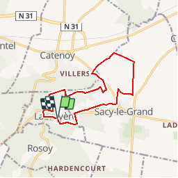
Tocht Stappen van 12,1 km beschikbaar op Hauts-de-France, Oise, Labruyère. Deze tocht wordt voorgesteld door tracegps.
Beschrijving
Marche organisée pour la journée de la maladie d’Huntington. Inscriptions 1€50, somme reversée pour la recherche de cette maladie dégénérative
Plaatsbepaling
Land:
France
Regio :
Hauts-de-France
Departement/Provincie :
Oise
Gemeente :
Labruyère
Locatie:
Unknown
Vertrek:(Dec)
Vertrek:(UTM)
464481 ; 5466630 (31U) N.
Opmerkingen
Wandeltochten in de omgeving
![Tocht Stappen Verderonne - verderonne - Photo](https://media.geolcdn.com/t/375/260/ext.jpg?maxdim=2&url=https%3A%2F%2Fstatic1.geolcdn.com%2Fsiteimages%2Fupload%2Ffiles%2F1553511878bg_sport_marche.png)
![Stappen Stappen](https://static1.geolcdn.com/sitytour/trail-icons/101.png)
verderonne
Stappen
Medium
(1)
Verderonne,
Hauts-de-France,
Oise,
France
![](/images/other/stat-length.png)
23 km | 27 km-effort
5h 0min
![](https://static1.geolcdn.com/siteimages/upload/files/16400158638029165_repeat_loop_refresh_sync_direction_icon.png)
Ja
![Tocht Stappen Bailleval - Rando cavée des Vaches - Photo](https://media.geolcdn.com/t/375/260/f37983ff-a1d8-4a86-849e-b7078bba4408.jpg&format=jpg&maxdim=2)
![Stappen Stappen](https://static1.geolcdn.com/sitytour/trail-icons/101.png)
Rando cavée des Vaches
Stappen
Gemakkelijk
Bailleval,
Hauts-de-France,
Oise,
France
![](/images/other/stat-length.png)
9,5 km | 11,6 km-effort
2h 49min
![](https://static1.geolcdn.com/siteimages/upload/files/16400158638029165_repeat_loop_refresh_sync_direction_icon.png)
Ja
![Tocht Stappen Verderonne - Randonnée de Rosoy à Verderonne - Photo](https://media.geolcdn.com/t/375/260/ext.jpg?maxdim=2&url=https%3A%2F%2Fservices.sitytrail.com%2FGeolivesWS%2FDownloadMedia.ashx%3FTrailID%3D106475%26Media%3D10997_1.jpg)
![Stappen Stappen](https://static1.geolcdn.com/sitytour/trail-icons/101.png)
Randonnée de Rosoy à Verderonne
Stappen
Medium
Verderonne,
Hauts-de-France,
Oise,
France
![](/images/other/stat-length.png)
8,3 km | 9,9 km-effort
1h 30min
![](https://static1.geolcdn.com/siteimages/upload/files/16400158638029165_repeat_loop_refresh_sync_direction_icon.png)
Ja
![Tocht Stappen Breuil-le-Sec - 2024 07 27 - Photo](https://media.geolcdn.com/t/375/260/ext.jpg?maxdim=2&url=https%3A%2F%2Fstatic1.geolcdn.com%2Fsiteimages%2Fupload%2Ffiles%2F1553511878bg_sport_marche.png)
![Stappen Stappen](https://static1.geolcdn.com/sitytour/trail-icons/101.png)
2024 07 27
Stappen
Gemakkelijk
Breuil-le-Sec,
Hauts-de-France,
Oise,
France
![](/images/other/stat-length.png)
16,3 km | 21 km-effort
4h 0min
![](https://static1.geolcdn.com/siteimages/upload/files/16400158638029165_repeat_loop_refresh_sync_direction_icon.png)
Ja
![Tocht Elektrische fiets Breuil-le-Sec - 2023 12 03 - Photo](https://media.geolcdn.com/t/375/260/ext.jpg?maxdim=2&url=https%3A%2F%2Fstatic1.geolcdn.com%2Fsiteimages%2Fupload%2Ffiles%2F1524743154velo.jpg)
![Elektrische fiets Elektrische fiets](https://static1.geolcdn.com/sitytour/trail-icons/205.png)
2023 12 03
Elektrische fiets
Medium
Breuil-le-Sec,
Hauts-de-France,
Oise,
France
![](/images/other/stat-length.png)
38 km | 51 km-effort
3h 27min
![](https://static1.geolcdn.com/siteimages/upload/files/16400158638029165_repeat_loop_refresh_sync_direction_icon.png)
Ja
![Tocht Elektrische fiets Breuil-le-Sec - 2022 10 29 - Photo](https://media.geolcdn.com/t/375/260/ext.jpg?maxdim=2&url=https%3A%2F%2Fstatic1.geolcdn.com%2Fsiteimages%2Fupload%2Ffiles%2F1524743154velo.jpg)
![Elektrische fiets Elektrische fiets](https://static1.geolcdn.com/sitytour/trail-icons/205.png)
2022 10 29
Elektrische fiets
Medium
Breuil-le-Sec,
Hauts-de-France,
Oise,
France
![](/images/other/stat-length.png)
47 km | 57 km-effort
4h 47min
![](https://static1.geolcdn.com/siteimages/upload/files/16400158638029165_repeat_loop_refresh_sync_direction_icon.png)
Ja
![Tocht Elektrische fiets Breuil-le-Sec - 2022 10 08 - Photo](https://media.geolcdn.com/t/375/260/ext.jpg?maxdim=2&url=https%3A%2F%2Fstatic1.geolcdn.com%2Fsiteimages%2Fupload%2Ffiles%2F1524743154velo.jpg)
![Elektrische fiets Elektrische fiets](https://static1.geolcdn.com/sitytour/trail-icons/205.png)
2022 10 08
Elektrische fiets
Gemakkelijk
Breuil-le-Sec,
Hauts-de-France,
Oise,
France
![](/images/other/stat-length.png)
29 km | 36 km-effort
3h 21min
![](https://static1.geolcdn.com/siteimages/upload/files/16400158638029165_repeat_loop_refresh_sync_direction_icon.png)
Ja
![Tocht Elektrische fiets Breuil-le-Sec - 2021 10 24 - Photo](https://media.geolcdn.com/t/375/260/ext.jpg?maxdim=2&url=https%3A%2F%2Fstatic1.geolcdn.com%2Fsiteimages%2Fupload%2Ffiles%2F1524743154velo.jpg)
![Elektrische fiets Elektrische fiets](https://static1.geolcdn.com/sitytour/trail-icons/205.png)
2021 10 24
Elektrische fiets
Medium
Breuil-le-Sec,
Hauts-de-France,
Oise,
France
![](/images/other/stat-length.png)
43 km | 58 km-effort
3h 33min
![](https://static1.geolcdn.com/siteimages/upload/files/16400158638029165_repeat_loop_refresh_sync_direction_icon.png)
Ja
![Tocht Mountainbike Breuil-le-Sec - 2020 10 26 - Photo](https://media.geolcdn.com/t/375/260/ext.jpg?maxdim=2&url=https%3A%2F%2Fstatic1.geolcdn.com%2Fsiteimages%2Fupload%2Ffiles%2F1524743154velo.jpg)
![Mountainbike Mountainbike](https://static1.geolcdn.com/sitytour/trail-icons/202.png)
2020 10 26
Mountainbike
Medium
Breuil-le-Sec,
Hauts-de-France,
Oise,
France
![](/images/other/stat-length.png)
35 km | 48 km-effort
2h 48min
![](https://static1.geolcdn.com/siteimages/upload/files/16400158638029165_repeat_loop_refresh_sync_direction_icon.png)
Ja