![](/images/other/stat-length.png)
![Tocht Mountainbike Coteaux du Lizon - Cuttura - Prés de la Rixouse - Photo](https://media.geolcdn.com/t/1900/400/ext.pjpeg?maxdim=2&url=https%3A%2F%2Fservices.sitytrail.com%2FGeolivesWS%2FDownloadMedia.ashx%3FTrailID%3D106472%26Media%3D10991_1.jpg)
Cuttura - Prés de la Rixouse
tracegps
Gebruiker
![Lengte](/images/other/stat-length.png)
![Max. hoogte](https://static1.geolcdn.com/siteimages/upload/files/1508320355ic_sort_altitude_max_24dp.png)
![Positief hoogteverschil](https://static1.geolcdn.com/siteimages/upload/files/1508320355ic_sort_den_pos_24dp.png)
![Km-Effort](/images/other/stat-length.png)
![Min. hoogte](https://static1.geolcdn.com/siteimages/upload/files/1508320355ic_sort_altitude_min_24dp.png)
![Negatief hoogteverschil](https://static1.geolcdn.com/siteimages/upload/files/1508320355ic_sort_den_neg_24dp.png)
![Boucle](https://static1.geolcdn.com/siteimages/upload/files/16400158638029165_repeat_loop_refresh_sync_direction_icon.png)
![Mountainbike](https://static1.geolcdn.com/sitytour/trail-icons/202.png)
2h30
Moeilijkheid : Medium
![Scan deze QR-code om de tocht te openen in de SityTrail-applicatie](https://capi.geolives.com/qq0zvz2zws4bq2lad0pu/sitytour/trails/106472/qr.png?size=200)
Gratisgps-wandelapplicatie
Over ons
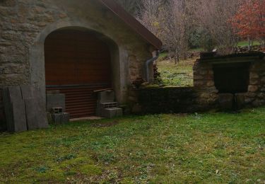
Tocht Mountainbike van 24 km beschikbaar op Bourgondië-Franche-Comté, Jura, Coteaux du Lizon. Deze tocht wordt voorgesteld door tracegps.
Beschrijving
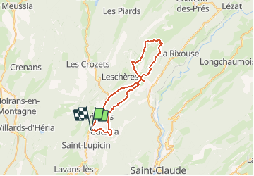
Départ: parking du lac de Cuttura. Itinéraire conseillé dans le sens: Lac de Cuttura -> Vichaumois -> Sur la Côte -> Les Prés de la Rixouse -> Les Prés de Valfin -> Sur la Côte -> Les Saumoires -> Cuttura - Lac de Cuttura. Attention: il est nécessaire de prendre une petite route en sens interdit sur 800m (à partir du Km 2) la prudence s'impose en roulant le plus possible sur le bas coté droit. Intérêts: table d'orientation de "Sur la Côte", éventuellement petit détour au belvédère du Capet. La difficulté de ce parcours est essentiellement la montée jusqu'à "sur la Côte". Ensuite, encore quelque montées mais pas très longues. Le retour depuis "Sur la Côte" jusqu'à "Cuttura" est essentiellement descendant et offre un tracé très ludique.
Plaatsbepaling
Opmerkingen
Wandeltochten in de omgeving
![Tocht Stappen Saint-Claude - Belvd. Pontoux depuis Rue des Perrieres à St-Claude 39200 - Photo](https://media.geolcdn.com/t/375/260/f9b19760-1bb3-48d6-b56c-4ed1797baa03.jpg&format=jpg&maxdim=2)
![Stappen Stappen](https://static1.geolcdn.com/sitytour/trail-icons/101.png)
Stappen
![](/images/other/stat-length.png)
![](https://static1.geolcdn.com/siteimages/upload/files/16400158638029165_repeat_loop_refresh_sync_direction_icon.png)
![Tocht Stappen Saint-Claude - St Claude Cascade de la Vouivre - Photo](https://media.geolcdn.com/t/375/260/223568e4-ca44-4832-866a-614785810ad8.jpg&format=jpg&maxdim=2)
![Stappen Stappen](https://static1.geolcdn.com/sitytour/trail-icons/101.png)
Stappen
![](/images/other/stat-length.png)
![](https://static1.geolcdn.com/siteimages/upload/files/16400158638029165_repeat_loop_refresh_sync_direction_icon.png)
![Tocht Te voet Coteaux du Lizon - Sentier des savoir-faire - Photo](https://media.geolcdn.com/t/375/260/5e891745-52e2-4c86-82b9-36da00a76ac0.jpeg&format=jpg&maxdim=2)
![Te voet Te voet](https://static1.geolcdn.com/sitytour/trail-icons/100.png)
Te voet
![](/images/other/stat-length.png)
![](https://static1.geolcdn.com/siteimages/upload/files/16400158638029165_repeat_loop_refresh_sync_direction_icon.png)
![Tocht Stappen Saint-Claude - De St-Claude à Vaucluse - Photo](https://media.geolcdn.com/t/375/260/6f07c1ae-93f7-4e21-bedc-a3f02b9c3c40.jpg&format=jpg&maxdim=2)
![Stappen Stappen](https://static1.geolcdn.com/sitytour/trail-icons/101.png)
Stappen
![](/images/other/stat-length.png)
![](https://static1.geolcdn.com/siteimages/upload/files/16400158638029165_repeat_loop_refresh_sync_direction_icon.png)
![Tocht Stappen Saint-Claude - les Prés de Valfin - Photo](https://media.geolcdn.com/t/375/260/ext.jpg?maxdim=2&url=https%3A%2F%2Fstatic1.geolcdn.com%2Fsiteimages%2Fupload%2Ffiles%2F1553511878bg_sport_marche.png)
![Stappen Stappen](https://static1.geolcdn.com/sitytour/trail-icons/101.png)
Stappen
![](/images/other/stat-length.png)
![](https://static1.geolcdn.com/siteimages/upload/files/16400158638029165_repeat_loop_refresh_sync_direction_icon.png)
![Tocht Stappen Coteaux du Lizon - Vallée du Lison - Photo](https://media.geolcdn.com/t/375/260/ext.jpg?maxdim=2&url=https%3A%2F%2Fstatic1.geolcdn.com%2Fsiteimages%2Fupload%2Ffiles%2F1553511878bg_sport_marche.png)
![Stappen Stappen](https://static1.geolcdn.com/sitytour/trail-icons/101.png)
Stappen
![](/images/other/stat-length.png)
![](https://static1.geolcdn.com/siteimages/upload/files/16400158638029165_repeat_loop_refresh_sync_direction_icon.png)
![Tocht Stappen Coteaux du Lizon - gorges du Lison . départ de Saint lupicin - Photo](https://media.geolcdn.com/t/375/260/286e2e3c-117d-4fdc-a219-2e81e971f03b.jpg&format=jpg&maxdim=2)
![Stappen Stappen](https://static1.geolcdn.com/sitytour/trail-icons/101.png)
Stappen
![](/images/other/stat-length.png)
![](https://static1.geolcdn.com/siteimages/upload/files/16400158638029165_repeat_loop_refresh_sync_direction_icon.png)
![Tocht Stappen Villards-d'Héria - lac d'Antre Belvédère de Scia - Photo](https://media.geolcdn.com/t/375/260/6cd2b4bc-9d84-4485-b770-90954281a052.jpg&format=jpg&maxdim=2)
![Stappen Stappen](https://static1.geolcdn.com/sitytour/trail-icons/101.png)
Stappen
![](/images/other/stat-length.png)
![](https://static1.geolcdn.com/siteimages/upload/files/16400158638029165_repeat_loop_refresh_sync_direction_icon.png)
![Tocht Stappen Villards-d'Héria - lac d antre - Photo](https://media.geolcdn.com/t/375/260/80be7616-6067-46a5-8c84-8aeff2838ece.jpg&format=jpg&maxdim=2)
![Stappen Stappen](https://static1.geolcdn.com/sitytour/trail-icons/101.png)
Stappen
![](/images/other/stat-length.png)
![](https://static1.geolcdn.com/siteimages/upload/files/16400158638029165_repeat_loop_refresh_sync_direction_icon.png)