![](/images/other/stat-length.png)
![Tocht Stappen Rémalard en Perche - TPE 2018 Etape 6-2 Rémalard - Condé-sur-Huisne par La Courroue 12.2 Km - Photo](https://media.geolcdn.com/t/1900/400/ext.pjpeg?maxdim=2&url=https%3A%2F%2Fstatic1.geolcdn.com%2Fsiteimages%2Fupload%2Ffiles%2F1553511878bg_sport_marche.png)
TPE 2018 Etape 6-2 Rémalard - Condé-sur-Huisne par La Courroue 12.2 Km
ODDAD78
Gebruiker
![Lengte](/images/other/stat-length.png)
![Max. hoogte](https://static1.geolcdn.com/siteimages/upload/files/1508320355ic_sort_altitude_max_24dp.png)
![Positief hoogteverschil](https://static1.geolcdn.com/siteimages/upload/files/1508320355ic_sort_den_pos_24dp.png)
![Km-Effort](/images/other/stat-length.png)
![Min. hoogte](https://static1.geolcdn.com/siteimages/upload/files/1508320355ic_sort_altitude_min_24dp.png)
![Negatief hoogteverschil](https://static1.geolcdn.com/siteimages/upload/files/1508320355ic_sort_den_neg_24dp.png)
![Boucle](https://static1.geolcdn.com/siteimages/upload/files/16400158638029165_repeat_loop_refresh_sync_direction_icon.png)
![Stappen](https://static1.geolcdn.com/sitytour/trail-icons/101.png)
3h16
Moeilijkheid : Gemakkelijk
![Scan deze QR-code om de tocht te openen in de SityTrail-applicatie](https://capi.geolives.com/qq0zvz2zws4bq2lad0pu/sitytour/trails/1063993/qr.png?size=200)
Gratisgps-wandelapplicatie
Over ons
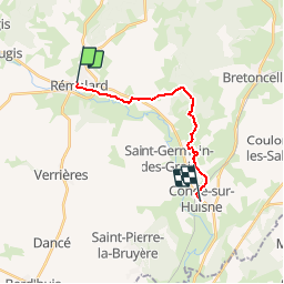
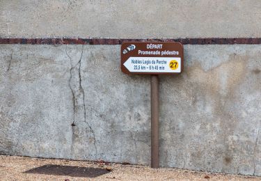
Tocht Stappen van 12,5 km beschikbaar op Normandië, Orne, Rémalard en Perche. Deze tocht wordt voorgesteld door ODDAD78.
Beschrijving
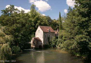
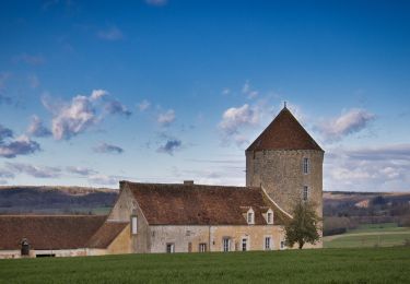
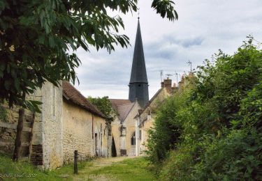
"Traversées Percheronnes" vous propose près de 90 randonnées linéaires organisées en mailles sur le territoire du grand Perche. Le maillage complet est visible sur une de nos photos.
Pour chaque ville ou village étape, nous vous proposons des destinations pouvant être atteintes à pied ou à VTT. Les traces et leurs destinations sont schématisées sur nos photos jointes.
Vous pouvez ainsi composer votre randonnée itinérante à la carte selon le nombre de jours dont vous disposez.... Et des capacités d'hébergement (possibilité de négocier un "taxi" auprès de certaines chambres d’hôtes).
Les topos guides détaillés sont disponible sur le blog de Traversées Percheronnes, hébergé par IGNRando
Site Web : https://ignrando.fr/fr/customer/communaute/index/
Plaatsbepaling
Opmerkingen
Wandeltochten in de omgeving
![Tocht Stappen Rémalard en Perche - La Nymphe du Perche 5,0 Km - Photo](https://media.geolcdn.com/t/375/260/17cc6b0d-b494-41c7-85a0-ede1466ba884.jpg&format=jpg&maxdim=2)
![Stappen Stappen](https://static1.geolcdn.com/sitytour/trail-icons/101.png)
Stappen
![](/images/other/stat-length.png)
![](https://static1.geolcdn.com/siteimages/upload/files/16400158638029165_repeat_loop_refresh_sync_direction_icon.png)
![Tocht Stappen Rémalard en Perche - 2023-05-11_20h45m08_Randos 61 2023 3 Sur les terres du siège de Rémalard 9,5 km - Photo](https://media.geolcdn.com/t/375/260/4c079e8c-69f5-4bc5-9fc4-11ac01016a7e.jpg&format=jpg&maxdim=2)
![Stappen Stappen](https://static1.geolcdn.com/sitytour/trail-icons/101.png)
Stappen
![](/images/other/stat-length.png)
![](https://static1.geolcdn.com/siteimages/upload/files/16400158638029165_repeat_loop_refresh_sync_direction_icon.png)
![Tocht Stappen Verrières - SityTrail - SityTrail - Les Vieilles Trognes 9 Km - Photo](https://media.geolcdn.com/t/375/260/2f52e433-da7f-4851-a063-0b8449b76186.jpg&format=jpg&maxdim=2)
![Stappen Stappen](https://static1.geolcdn.com/sitytour/trail-icons/101.png)
Stappen
![](/images/other/stat-length.png)
![](https://static1.geolcdn.com/siteimages/upload/files/16400158638029165_repeat_loop_refresh_sync_direction_icon.png)
![Tocht Stappen Rémalard en Perche - Nobles Logis du Perche (Rémalard) Variante 8,3 Km - Photo](https://media.geolcdn.com/t/375/260/8d898521-16be-4b88-87ed-874030b976e2.jpg&format=jpg&maxdim=2)
![Stappen Stappen](https://static1.geolcdn.com/sitytour/trail-icons/101.png)
Stappen
![](/images/other/stat-length.png)
![](https://static1.geolcdn.com/siteimages/upload/files/16400158638029165_repeat_loop_refresh_sync_direction_icon.png)
![Tocht Stappen Cour-Maugis sur Huisne - Boissy-Maugis 8,4 km - Photo](https://media.geolcdn.com/t/375/260/b8f9aaa7-b59b-4d9c-ba02-624dc17d6137.jpg&format=jpg&maxdim=2)
![Stappen Stappen](https://static1.geolcdn.com/sitytour/trail-icons/101.png)
Stappen
![](/images/other/stat-length.png)
![](https://static1.geolcdn.com/siteimages/upload/files/16400158638029165_repeat_loop_refresh_sync_direction_icon.png)
![Tocht Stappen Rémalard en Perche - Le ruisseau de Pontillon 11 Km - Photo](https://media.geolcdn.com/t/375/260/ff177aee-f1f8-438f-adec-36e6a48cd0c9.jpg&format=jpg&maxdim=2)
![Stappen Stappen](https://static1.geolcdn.com/sitytour/trail-icons/101.png)
Stappen
![](/images/other/stat-length.png)
![](https://static1.geolcdn.com/siteimages/upload/files/16400158638029165_repeat_loop_refresh_sync_direction_icon.png)
![Tocht Stappen Rémalard en Perche - Nobles Logis du Perche (Rémalard) 24 Km - Photo](https://media.geolcdn.com/t/375/260/1e8cc532-bb5b-4a9b-8b5a-736f25271548.jpg&format=jpg&maxdim=2)
![Stappen Stappen](https://static1.geolcdn.com/sitytour/trail-icons/101.png)
Stappen
![](/images/other/stat-length.png)
![](https://static1.geolcdn.com/siteimages/upload/files/16400158638029165_repeat_loop_refresh_sync_direction_icon.png)
![Tocht Stappen Cour-Maugis sur Huisne - La Clairière de Saint-Laurent 16,0 Km - Photo](https://media.geolcdn.com/t/375/260/5813c593-509f-42a8-97e4-39a0b1a6860f.jpg&format=jpg&maxdim=2)
![Stappen Stappen](https://static1.geolcdn.com/sitytour/trail-icons/101.png)
Stappen
![](/images/other/stat-length.png)
![](https://static1.geolcdn.com/siteimages/upload/files/16400158638029165_repeat_loop_refresh_sync_direction_icon.png)
![Tocht Stappen Cour-Maugis sur Huisne - La Sentinelle de Commeauche 6.2 Km - Photo](https://media.geolcdn.com/t/375/260/d98060ba-ccea-422e-b357-0a71da289596.jpg&format=jpg&maxdim=2)
![Stappen Stappen](https://static1.geolcdn.com/sitytour/trail-icons/101.png)
Stappen
![](/images/other/stat-length.png)
![](https://static1.geolcdn.com/siteimages/upload/files/16400158638029165_repeat_loop_refresh_sync_direction_icon.png)