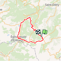
![](/images/other/stat-length.png)
![Tocht Mountainbike Compains - VTT autour de Brion - Photo](https://media.geolcdn.com/t/1900/400/ext.pjpeg?maxdim=2&url=https%3A%2F%2Fstatic1.geolcdn.com%2Fsiteimages%2Fupload%2Ffiles%2F1524743154velo.jpg)
VTT autour de Brion
tracegps
Gebruiker
![Lengte](/images/other/stat-length.png)
![Max. hoogte](https://static1.geolcdn.com/siteimages/upload/files/1508320355ic_sort_altitude_max_24dp.png)
![Positief hoogteverschil](https://static1.geolcdn.com/siteimages/upload/files/1508320355ic_sort_den_pos_24dp.png)
![Km-Effort](/images/other/stat-length.png)
![Min. hoogte](https://static1.geolcdn.com/siteimages/upload/files/1508320355ic_sort_altitude_min_24dp.png)
![Negatief hoogteverschil](https://static1.geolcdn.com/siteimages/upload/files/1508320355ic_sort_den_neg_24dp.png)
![Boucle](https://static1.geolcdn.com/siteimages/upload/files/16400158638029165_repeat_loop_refresh_sync_direction_icon.png)
![Mountainbike](https://static1.geolcdn.com/sitytour/trail-icons/202.png)
6h00
Moeilijkheid : Moeilijk
![Scan deze QR-code om de tocht te openen in de SityTrail-applicatie](https://capi.geolives.com/qq0zvz2zws4bq2lad0pu/sitytour/trails/106353/qr.png?size=200)
Gratisgps-wandelapplicatie
Over ons
Tocht Mountainbike van 44 km beschikbaar op Auvergne-Rhône-Alpes, Puy-de-Dôme, Compains. Deze tocht wordt voorgesteld door tracegps.
Beschrijving
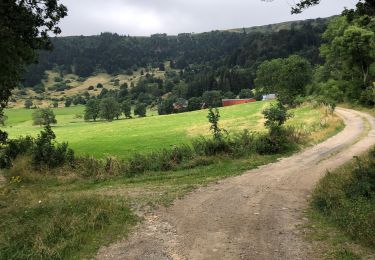
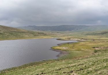
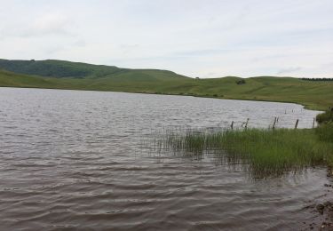
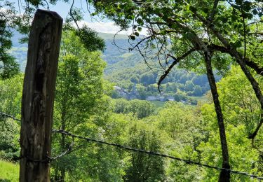
Jolie balade dans le Cézalier qui alterne les pistes roulantes et le monotrail. Nombreuses variantes possibles, notamment autour du Lac Pavin les jours où il n'y a pas trop de randonneurs, ou le long du Lac de Montcineyre s'il le niveau est bas. Le coté difficile n'est qu'une appréciation personnelle liée à la distance du parcours. Bonne balade et si vous la faite, partager votre avis.
Plaatsbepaling
Opmerkingen
Wandeltochten in de omgeving
![Stappen Stappen](https://static1.geolcdn.com/sitytour/trail-icons/101.png)
Stappen
![](/images/other/stat-length.png)
![](https://static1.geolcdn.com/siteimages/upload/files/16400158638029165_repeat_loop_refresh_sync_direction_icon.png)
![Tocht Te voet Saint-Alyre-ès-Montagne - Jassy - Photo](https://media.geolcdn.com/t/375/260/f6a39d7f-3eb2-4bee-b23e-c7306ca9ede6.jpeg&format=jpg&maxdim=2)
![Te voet Te voet](https://static1.geolcdn.com/sitytour/trail-icons/100.png)
Te voet
![](/images/other/stat-length.png)
![](https://static1.geolcdn.com/siteimages/upload/files/16400158638029165_repeat_loop_refresh_sync_direction_icon.png)
![Tocht Te voet Compains - La Chapelle Saint-Gorgon - Photo](https://media.geolcdn.com/t/375/260/cf7706da-a981-451b-a81f-d62aad5b30f6.jpeg&format=jpg&maxdim=2)
![Te voet Te voet](https://static1.geolcdn.com/sitytour/trail-icons/100.png)
Te voet
![](/images/other/stat-length.png)
![](https://static1.geolcdn.com/siteimages/upload/files/16400158638029165_repeat_loop_refresh_sync_direction_icon.png)
![Tocht Stappen Compains - Brion-Anzat le Luguet TVR - Photo](https://media.geolcdn.com/t/375/260/12ace1df-d788-43c7-b056-92d1d1825139.jpg&format=jpg&maxdim=2)
![Stappen Stappen](https://static1.geolcdn.com/sitytour/trail-icons/101.png)
Stappen
![](/images/other/stat-length.png)
![](https://static1.geolcdn.com/siteimages/upload/files/16400158638029165_repeat_loop_refresh_sync_direction_icon.png)
![Tocht Stappen La Godivelle - boucle la godivelle jassy 15km - Photo](https://media.geolcdn.com/t/375/260/cf691889-7eab-458e-8f1a-dea426450050.jpg&format=jpg&maxdim=2)
![Stappen Stappen](https://static1.geolcdn.com/sitytour/trail-icons/101.png)
Stappen
![](/images/other/stat-length.png)
![](https://static1.geolcdn.com/siteimages/upload/files/16400158638029165_repeat_loop_refresh_sync_direction_icon.png)
![Tocht Te voet Roche-Charles-la-Mayrand - La Chapelle de Roche-Charles - Photo](https://media.geolcdn.com/t/375/260/ext.jpg?maxdim=2&url=https%3A%2F%2Fupload.wikimedia.org%2Fwikipedia%2Fcommons%2Fthumb%2Fd%2Fd8%2FRoche_Charles.jpg%2F2000px-Roche_Charles.jpg)
![Te voet Te voet](https://static1.geolcdn.com/sitytour/trail-icons/100.png)
Te voet
![](/images/other/stat-length.png)
![](https://static1.geolcdn.com/siteimages/upload/files/16400158638029165_repeat_loop_refresh_sync_direction_icon.png)
![Tocht Stappen La Godivelle - La Godivelle - Mt Chamaroux - la Godivelle - Photo](https://media.geolcdn.com/t/375/260/441f9256-fb8a-465f-b457-c6ff2b09e578.jpg&format=jpg&maxdim=2)
![Stappen Stappen](https://static1.geolcdn.com/sitytour/trail-icons/101.png)
Stappen
![](/images/other/stat-length.png)
![](https://static1.geolcdn.com/siteimages/upload/files/16400158638029165_repeat_loop_refresh_sync_direction_icon.png)
![Tocht Stappen Saint-Alyre-ès-Montagne - Jassy brion La Godivelle - Photo](https://media.geolcdn.com/t/375/260/7be303b1-1301-4f3e-a14f-a24f9414e5ff.jpg&format=jpg&maxdim=2)
![Stappen Stappen](https://static1.geolcdn.com/sitytour/trail-icons/101.png)
Stappen
![](/images/other/stat-length.png)
![](https://static1.geolcdn.com/siteimages/upload/files/16400158638029165_repeat_loop_refresh_sync_direction_icon.png)
![Tocht Stappen Compains - lac Moncineyre - Photo](https://media.geolcdn.com/t/375/260/46c9091c-1d0a-4048-a1fc-9f835ce17fad.jpg&format=jpg&maxdim=2)
![Stappen Stappen](https://static1.geolcdn.com/sitytour/trail-icons/101.png)
Stappen
![](/images/other/stat-length.png)
![](https://static1.geolcdn.com/siteimages/upload/files/16400158638029165_repeat_loop_refresh_sync_direction_icon.png)