![](/images/other/stat-length.png)
![Tocht Stappen Saint-Agrève - Chemin de Saint Régis: Saint Agrève - Lalouvesc - Photo](https://media.geolcdn.com/t/1900/400/ext.pjpeg?maxdim=2&url=https%3A%2F%2Fservices.sitytrail.com%2FGeolivesWS%2FDownloadMedia.ashx%3FTrailID%3D106325%26Media%3D10770_2.jpg)
Chemin de Saint Régis: Saint Agrève - Lalouvesc
tracegps
Gebruiker
![Lengte](/images/other/stat-length.png)
![Max. hoogte](https://static1.geolcdn.com/siteimages/upload/files/1508320355ic_sort_altitude_max_24dp.png)
![Positief hoogteverschil](https://static1.geolcdn.com/siteimages/upload/files/1508320355ic_sort_den_pos_24dp.png)
![Km-Effort](/images/other/stat-length.png)
![Min. hoogte](https://static1.geolcdn.com/siteimages/upload/files/1508320355ic_sort_altitude_min_24dp.png)
![Negatief hoogteverschil](https://static1.geolcdn.com/siteimages/upload/files/1508320355ic_sort_den_neg_24dp.png)
![Boucle](https://static1.geolcdn.com/siteimages/upload/files/16400158638029165_repeat_loop_refresh_sync_direction_icon.png)
![Stappen](https://static1.geolcdn.com/sitytour/trail-icons/101.png)
9h00
Moeilijkheid : Moeilijk
![Scan deze QR-code om de tocht te openen in de SityTrail-applicatie](https://capi.geolives.com/qq0zvz2zws4bq2lad0pu/sitytour/trails/106325/qr.png?size=200)
Gratisgps-wandelapplicatie
Over ons
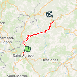
Tocht Stappen van 29 km beschikbaar op Auvergne-Rhône-Alpes, Ardèche, Saint-Agrève. Deze tocht wordt voorgesteld door tracegps.
Beschrijving
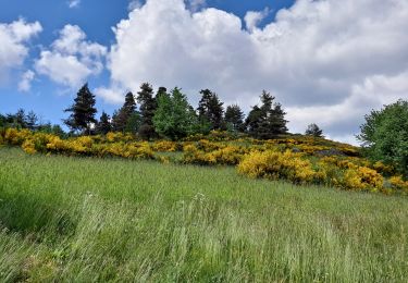
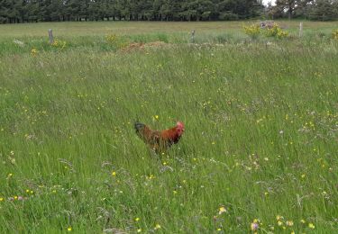
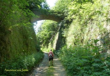
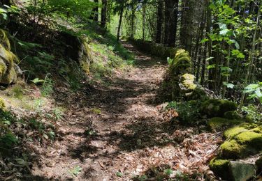
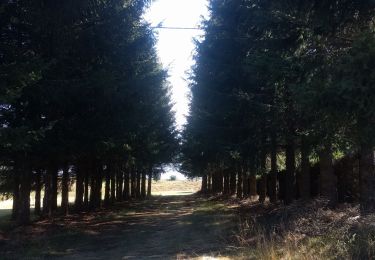
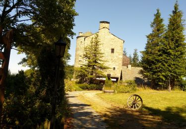
Encore une grande étape sans dénivelée excessive. Entre Saint-Agrève et Lalouvesc, le tracé est plus sinueux et plus accidenté que dans le Mézenc. Le chemin descend dans le fond des vallées à la rencontre de l’eau vive avant de grimper à l’assaut des cols et des mamelons en épousant les flancs arrondis de la montagne. Le plus souvent, il se cache dans les sous-bois et prive le marcheur du panorama, ce qui rend le parcours un peu monotone et frustrant. Je préfère nettement les plateaux dégagés du Mézenc qui donnent la mesure de l’immensité, à ces chemins du Vivarais phagocytés par des forêts desquelles ils ne parviennent à s’extraire péniblement que l’espace de quelques kilomètres. Mais heureusement, au cours de ces traversées à l’air libre, on peut souvent apercevoir au loin, promesse d’une halte à venir, un village pittoresque posé sur la crête enchâssé dans un écrin de prairies verdoyantes émergeant de la forêt : hier, c’était Rochepaule, aujourd’hui Saint-Pierre-sur-Doux… La suite du récit est ICI.
Plaatsbepaling
Opmerkingen
Wandeltochten in de omgeving
![Tocht Stappen Saint-Jeure-d'Andaure - En pays d'Andaure - Photo](https://media.geolcdn.com/t/375/260/ext.jpg?maxdim=2&url=https%3A%2F%2Fservices.sitytrail.com%2FGeolivesWS%2FDownloadMedia.ashx%3FTrailID%3D129815%26Media%3D13364_6.jpg)
![Stappen Stappen](https://static1.geolcdn.com/sitytour/trail-icons/101.png)
Stappen
![](/images/other/stat-length.png)
![](https://static1.geolcdn.com/siteimages/upload/files/16400158638029165_repeat_loop_refresh_sync_direction_icon.png)
![Tocht Stappen Saint-Agrève - La chaux par les Sagnoles - Photo](https://media.geolcdn.com/t/375/260/2ec8b69d-9d2d-4eb0-8ab2-4718ed369489.jpg&format=jpg&maxdim=2)
![Stappen Stappen](https://static1.geolcdn.com/sitytour/trail-icons/101.png)
Stappen
![](/images/other/stat-length.png)
![](https://static1.geolcdn.com/siteimages/upload/files/16400158638029165_repeat_loop_refresh_sync_direction_icon.png)
![Tocht Stappen Saint-Agrève - Le serre par le col de brun - Photo](https://media.geolcdn.com/t/375/260/0ab7f4ef-e569-4c05-ab5d-1eb0828a7e96.jpg&format=jpg&maxdim=2)
![Stappen Stappen](https://static1.geolcdn.com/sitytour/trail-icons/101.png)
Stappen
![](/images/other/stat-length.png)
![](https://static1.geolcdn.com/siteimages/upload/files/16400158638029165_repeat_loop_refresh_sync_direction_icon.png)
![Tocht Mountainbike Saint-Agrève - Château de Flossac - Saint Agrève - Photo](https://media.geolcdn.com/t/375/260/ext.jpg?maxdim=2&url=https%3A%2F%2Fservices.sitytrail.com%2FGeolivesWS%2FDownloadMedia.ashx%3FTrailID%3D215181%26Media%3D15781_6.jpg)
![Mountainbike Mountainbike](https://static1.geolcdn.com/sitytour/trail-icons/202.png)
Mountainbike
![](/images/other/stat-length.png)
![](https://static1.geolcdn.com/siteimages/upload/files/16400158638029165_repeat_loop_refresh_sync_direction_icon.png)
![Tocht Stappen Saint-Agrève - Château de Flossac - Saint Agrève - Photo](https://media.geolcdn.com/t/375/260/ext.jpg?maxdim=2&url=https%3A%2F%2Fservices.sitytrail.com%2FGeolivesWS%2FDownloadMedia.ashx%3FTrailID%3D215180%26Media%3D15781_6.jpg)
![Stappen Stappen](https://static1.geolcdn.com/sitytour/trail-icons/101.png)
Stappen
![](/images/other/stat-length.png)
![](https://static1.geolcdn.com/siteimages/upload/files/16400158638029165_repeat_loop_refresh_sync_direction_icon.png)
![Tocht Stappen Saint-Agrève - Saint-Agrève - Photo](https://media.geolcdn.com/t/375/260/f29c2b82-43c8-4052-a60d-cd95cfb4626d.jpg&format=jpg&maxdim=2)
![Stappen Stappen](https://static1.geolcdn.com/sitytour/trail-icons/101.png)
Stappen
![](/images/other/stat-length.png)
![](https://static1.geolcdn.com/siteimages/upload/files/16400158638029165_repeat_loop_refresh_sync_direction_icon.png)
![Tocht Stappen Saint-Julien-d'Intres - dolce via autour d'intres - Photo](https://media.geolcdn.com/t/375/260/6fbf7f44-82be-4874-938e-1b127a40d4fe.jpg&format=jpg&maxdim=2)
![Stappen Stappen](https://static1.geolcdn.com/sitytour/trail-icons/101.png)
Stappen
![](/images/other/stat-length.png)
![](https://static1.geolcdn.com/siteimages/upload/files/16400158638029165_repeat_loop_refresh_sync_direction_icon.png)
![Tocht Stappen Devesset - Tour du lac Devesset - Photo](https://media.geolcdn.com/t/375/260/799511a5-cd66-4185-9dfe-fcafa1be1770.jpg&format=jpg&maxdim=2)
![Stappen Stappen](https://static1.geolcdn.com/sitytour/trail-icons/101.png)
Stappen
![](/images/other/stat-length.png)
![](https://static1.geolcdn.com/siteimages/upload/files/16400158638029165_repeat_loop_refresh_sync_direction_icon.png)
![Tocht Stappen Devesset - le grail - Photo](https://media.geolcdn.com/t/375/260/2b05e325-e4fc-4530-95a7-2b1114c525d0.jpg&format=jpg&maxdim=2)
![Stappen Stappen](https://static1.geolcdn.com/sitytour/trail-icons/101.png)
Stappen
![](/images/other/stat-length.png)
![](https://static1.geolcdn.com/siteimages/upload/files/16400158638029165_repeat_loop_refresh_sync_direction_icon.png)