Tocht Stappen Παλαιοκαστρίτσα - Autour de Lakones - Photo
 Roulland
Roulland

Gebruiker

© OpenStreetMap contributors
Lengte
Lengte
15,4 km
Max. hoogte
Max. hoogte
427 m
Positief hoogteverschil
749 m
Km-Effort
Km-Effort  
25 km
Min. hoogte
Min. hoogte
-2 m
Negatief hoogteverschil
736 m
Boucle
Boucle
Ja
Datum van aanmaak :
2019-01-15 18:05:16.66
Laatste wijziging :
2019-01-15 18:05:16.66

(0 Bericht)

Stappen
Stappen
5h55
Moeilijkheid : Medium

Scan deze QR-code om de tocht te openen in de SityTrail-applicatie

Gratisgps-wandelapplicatie

Logo SityTrail SityTrail

IGN / Geografische instituten

SityTrail uit de App Store downloaden SityTrail uit Google Play downloaden

Logo SityTrail SityTrail World

De wereld gaat voor u open

SityTrail uit de App Store downloaden SityTrail uit Google Play downloaden SityTrail op Huawei AppGallery downloaden

Over ons

Tocht Stappen van 15,4 km beschikbaar op Peloponnesos, West-Griekenland en Ionische Eilanden, Περιφερειακή Ενότητα Κέρκυρας. Deze tocht wordt voorgesteld door Roulland.

Hoogteprofiel

Foto's

Plaatsbepaling

Land:
Greece
Regio :
Peloponnesos, West-Griekenland en Ionische Eilanden
Departement/Provincie :
Περιφερειακή Ενότητα Κέρκυρας
Gemeente :
Παλαιοκαστρίτσα
Locatie:
Unknown
Vertrek:(Dec)
Vertrek:(UTM)
389037 ; 4392259 (34S) N.

Wandeltochten in de omgeving

Tocht Stappen  - Autour de Lakones - Photo
Stappen
Roulland

Stappen

Medium
, Peloponnesos, West-Griekenland en Ionische Eilanden, Περιφερειακή Ενότητα Κέρκυρας, Greece
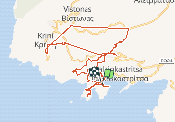
15,4 km | 25 km-effort
5h 55min
Ja


Sluiten
Mijn abonnementen