![](/images/other/stat-length.png)
![Tocht Stappen Bézaudun-sur-Bîne - Le Grand Delmas - Col de la Chaudière - Photo](https://media.geolcdn.com/t/1900/400/ext.pjpeg?maxdim=2&url=https%3A%2F%2Fservices.sitytrail.com%2FGeolivesWS%2FDownloadMedia.ashx%3FTrailID%3D106199%26Media%3D10490_1.jpg)
Le Grand Delmas - Col de la Chaudière
tracegps
Gebruiker
![Lengte](/images/other/stat-length.png)
![Max. hoogte](https://static1.geolcdn.com/siteimages/upload/files/1508320355ic_sort_altitude_max_24dp.png)
![Positief hoogteverschil](https://static1.geolcdn.com/siteimages/upload/files/1508320355ic_sort_den_pos_24dp.png)
![Km-Effort](/images/other/stat-length.png)
![Min. hoogte](https://static1.geolcdn.com/siteimages/upload/files/1508320355ic_sort_altitude_min_24dp.png)
![Negatief hoogteverschil](https://static1.geolcdn.com/siteimages/upload/files/1508320355ic_sort_den_neg_24dp.png)
![Boucle](https://static1.geolcdn.com/siteimages/upload/files/16400158638029165_repeat_loop_refresh_sync_direction_icon.png)
![Stappen](https://static1.geolcdn.com/sitytour/trail-icons/101.png)
4h00
Moeilijkheid : Moeilijk
![Scan deze QR-code om de tocht te openen in de SityTrail-applicatie](https://capi.geolives.com/qq0zvz2zws4bq2lad0pu/sitytour/trails/106199/qr.png?size=200)
Gratisgps-wandelapplicatie
Over ons
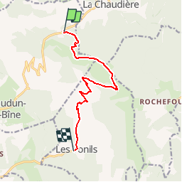
Tocht Stappen van 9,8 km beschikbaar op Auvergne-Rhône-Alpes, Drôme, Bézaudun-sur-Bîne. Deze tocht wordt voorgesteld door tracegps.
Beschrijving
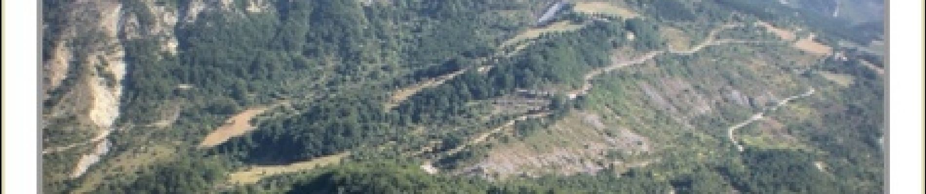
Le départ s'effectue à environ 200 m avant le col de la Chaudière (panneau le Grand Delmas) en venant de Bourdeaux. Pas de problème pour se garer, de nombreux emplacement le long de la route et grand parking ver le col. La montée est très raide et traverse la forêt avec quelques beaux points de vue vers le nord. Un dernier raidillon permet d'accéder à un petit col, à partir de ce moment il n'y a plus qu'à suivre les crêtes. La trace GPS fait un crochet à ne pas suivre sauf, si comme nous, 3 énormes Patous vous prient avec force aboiements de modifier votre itinéraire pour cause de moutons. Sinon la ligne des crêtes permet une vue magnifique au milieu de prairies. La descente est assez longue vers les Tonils mais pas désagréable, un joli paysage. Il existe une possibilité de boucle, un chemin à mi descente permettant de rejoindre la D 156 par le Col du Lion.
Plaatsbepaling
Opmerkingen
Wandeltochten in de omgeving
![Tocht Stappen Bourdeaux - Chemin des protestants- Bourdaux - Photo](https://media.geolcdn.com/t/375/260/c9690b91-aa42-47d0-b809-97d643432899.jpg&format=jpg&maxdim=2)
![Stappen Stappen](https://static1.geolcdn.com/sitytour/trail-icons/101.png)
Stappen
![](/images/other/stat-length.png)
![](https://static1.geolcdn.com/siteimages/upload/files/16400158638029165_repeat_loop_refresh_sync_direction_icon.png)
![Tocht Stappen Saou - saou.les 3 becs - Photo](https://media.geolcdn.com/t/375/260/ext.jpg?maxdim=2&url=https%3A%2F%2Fservices.sitytrail.com%2FGeolivesWS%2FDownloadMedia.ashx%3FTrailID%3D329039%26Media%3Dfix__20140719140834.jpg)
![Stappen Stappen](https://static1.geolcdn.com/sitytour/trail-icons/101.png)
Stappen
![](/images/other/stat-length.png)
![](https://static1.geolcdn.com/siteimages/upload/files/16400158638029165_repeat_loop_refresh_sync_direction_icon.png)
![Tocht Stappen La Chaudière - Les 3 Becs - Photo](https://media.geolcdn.com/t/375/260/ext.jpg?maxdim=2&url=https%3A%2F%2Fservices.sitytrail.com%2FGeolivesWS%2FDownloadMedia.ashx%3FTrailID%3D218224%26Media%3Dfix__20130901120821.jpg)
![Stappen Stappen](https://static1.geolcdn.com/sitytour/trail-icons/101.png)
Stappen
![](/images/other/stat-length.png)
![](https://static1.geolcdn.com/siteimages/upload/files/16400158638029165_repeat_loop_refresh_sync_direction_icon.png)
![Tocht Stappen La Chaudière - La chaudiere - chapelle des Sadoux - Photo](https://media.geolcdn.com/t/375/260/fe29fe3e-8696-4fc7-af92-f6d3eeb26877.jpg&format=jpg&maxdim=2)
![Stappen Stappen](https://static1.geolcdn.com/sitytour/trail-icons/101.png)
Stappen
![](/images/other/stat-length.png)
![](https://static1.geolcdn.com/siteimages/upload/files/16400158638029165_repeat_loop_refresh_sync_direction_icon.png)
![Tocht Stappen Bézaudun-sur-Bîne - 2022-09-26_14h18m42_12295156 - Photo](https://media.geolcdn.com/t/375/260/f11da23a-0048-4e80-a120-e8dd7afb6f22.jpg&format=jpg&maxdim=2)
![Stappen Stappen](https://static1.geolcdn.com/sitytour/trail-icons/101.png)
Stappen
![](/images/other/stat-length.png)
![](https://static1.geolcdn.com/siteimages/upload/files/16400158638029165_repeat_loop_refresh_sync_direction_icon.png)
![Tocht Wegfiets Mornans - Col de Chaudiere, Saillans, Col de muse, Crupies - Photo](https://media.geolcdn.com/t/375/260/b8fcd270-be8e-430a-92ee-e05ed8f76209.jpg&format=jpg&maxdim=2)
![Wegfiets Wegfiets](https://static1.geolcdn.com/sitytour/trail-icons/201.png)
Wegfiets
![](/images/other/stat-length.png)
![](https://static1.geolcdn.com/siteimages/upload/files/16400158638029165_repeat_loop_refresh_sync_direction_icon.png)
![Tocht Stappen La Chaudière - les 3becs et arches - Photo](https://media.geolcdn.com/t/375/260/97464636-1260-4d97-b592-83a9cda2a983.jpg&format=jpg&maxdim=2)
![Stappen Stappen](https://static1.geolcdn.com/sitytour/trail-icons/101.png)
Stappen
![](/images/other/stat-length.png)
![](https://static1.geolcdn.com/siteimages/upload/files/16400158638029165_repeat_loop_refresh_sync_direction_icon.png)
![Tocht Stappen La Chaudière - les trois becs - Photo](https://media.geolcdn.com/t/375/260/ext.jpg?maxdim=2&url=https%3A%2F%2Fservices.sitytrail.com%2FGeolivesWS%2FDownloadMedia.ashx%3FTrailID%3D997850%26Media%3Dfix__20180701153419.jpg)
![Stappen Stappen](https://static1.geolcdn.com/sitytour/trail-icons/101.png)
Stappen
![](/images/other/stat-length.png)
![](https://static1.geolcdn.com/siteimages/upload/files/16400158638029165_repeat_loop_refresh_sync_direction_icon.png)
![Tocht Stappen La Chaudière - La chaudière- chapelle des Sadoux - Photo](https://media.geolcdn.com/t/375/260/6819e1ce-f278-49e2-9b64-8d59d930cfa9.jpg&format=jpg&maxdim=2)
![Stappen Stappen](https://static1.geolcdn.com/sitytour/trail-icons/101.png)
Stappen
![](/images/other/stat-length.png)
![](https://static1.geolcdn.com/siteimages/upload/files/16400158638029165_repeat_loop_refresh_sync_direction_icon.png)
Delmas