![](/images/other/stat-length.png)
![Tocht Stappen Valdrôme - Les crêtes du Duffre - Le Pré Pourri - Photo](https://media.geolcdn.com/t/1900/400/ext.pjpeg?maxdim=2&url=https%3A%2F%2Fservices.sitytrail.com%2FGeolivesWS%2FDownloadMedia.ashx%3FTrailID%3D106195%26Media%3D10487_4.jpg)
Les crêtes du Duffre - Le Pré Pourri
tracegps
Gebruiker
![Lengte](/images/other/stat-length.png)
![Max. hoogte](https://static1.geolcdn.com/siteimages/upload/files/1508320355ic_sort_altitude_max_24dp.png)
![Positief hoogteverschil](https://static1.geolcdn.com/siteimages/upload/files/1508320355ic_sort_den_pos_24dp.png)
![Km-Effort](/images/other/stat-length.png)
![Min. hoogte](https://static1.geolcdn.com/siteimages/upload/files/1508320355ic_sort_altitude_min_24dp.png)
![Negatief hoogteverschil](https://static1.geolcdn.com/siteimages/upload/files/1508320355ic_sort_den_neg_24dp.png)
![Boucle](https://static1.geolcdn.com/siteimages/upload/files/16400158638029165_repeat_loop_refresh_sync_direction_icon.png)
![Stappen](https://static1.geolcdn.com/sitytour/trail-icons/101.png)
3h00
Moeilijkheid : Medium
![Scan deze QR-code om de tocht te openen in de SityTrail-applicatie](https://capi.geolives.com/qq0zvz2zws4bq2lad0pu/sitytour/trails/106195/qr.png?size=200)
Gratisgps-wandelapplicatie
Over ons
Tocht Stappen van 6,4 km beschikbaar op Auvergne-Rhône-Alpes, Drôme, Valdrôme. Deze tocht wordt voorgesteld door tracegps.
Beschrijving
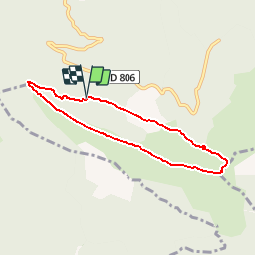
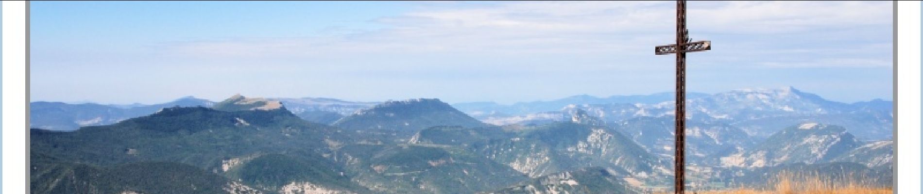
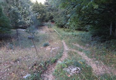
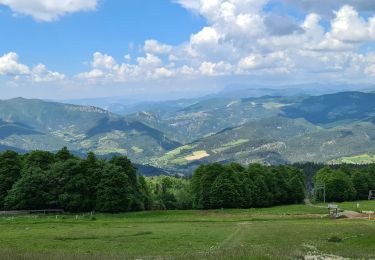
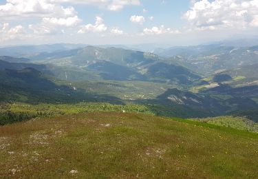
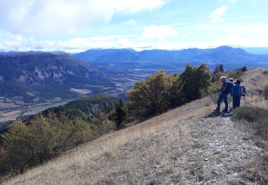
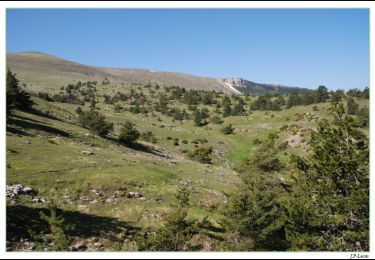
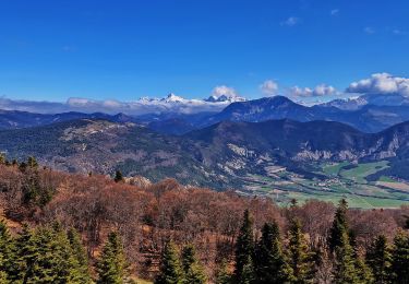
L'approche se fait en voiture à partir de Valdrôme vers la station de Ski. Avant d'arriver à la station prendre le chemin vers le lieu "Le Pré Pourri" Garer sa voiture au petit parking, monter les escaliers jusqu'à la cabane et suivre le chemin vers l'ouest jusqu'à un col. On quitte le chemin pour grimper sur la gauche dans des rochers. Il n'y a plus qu'à suivre les crêtes, vue sur toute la région, jusqu'au sommet du Duffre d'où l'on a une vue à 380 ° superbe. Redescendre par la face nord entre le Duffre et la Pyramide jusqu'au chemin que l'on prendre sur la gauche pour retrouver le parking du pré Pourri. Sur les crêtes quelques passages rocheux pouvant être impressionnants mais pas de difficultés particulières.
Plaatsbepaling
Opmerkingen
Wandeltochten in de omgeving
![Tocht Mountainbike La Piarre - VTT27 - Sous le Duffre - Photo](https://media.geolcdn.com/t/375/260/ext.jpg?maxdim=2&url=https%3A%2F%2Fservices.sitytrail.com%2FGeolivesWS%2FDownloadMedia.ashx%3FTrailID%3D894047%26Media%3Ded5e547b-8f08-467d-af12-6e0e0924207d.jpg)
![Mountainbike Mountainbike](https://static1.geolcdn.com/sitytour/trail-icons/202.png)
Mountainbike
![](/images/other/stat-length.png)
![](https://static1.geolcdn.com/siteimages/upload/files/16400158638029165_repeat_loop_refresh_sync_direction_icon.png)
![Tocht Mountainbike La Piarre - VTT24 - De La Piarre à Valdrôme - Photo](https://media.geolcdn.com/t/375/260/ext.jpg?maxdim=2&url=https%3A%2F%2Fservices.sitytrail.com%2FGeolivesWS%2FDownloadMedia.ashx%3FTrailID%3D894038%26Media%3Db248c1de-539b-4dff-b0c7-1e7842e94c38.jpg)
![Mountainbike Mountainbike](https://static1.geolcdn.com/sitytour/trail-icons/202.png)
Mountainbike
![](/images/other/stat-length.png)
![](https://static1.geolcdn.com/siteimages/upload/files/16400158638029165_repeat_loop_refresh_sync_direction_icon.png)
![Tocht Stappen Valdrôme - R34 Le Duffre - Photo](https://media.geolcdn.com/t/375/260/ext.jpg?maxdim=2&url=https%3A%2F%2Fservices.sitytrail.com%2FGeolivesWS%2FDownloadMedia.ashx%3FTrailID%3D890893%26Media%3D2ca1e21a-61a3-4d74-8f49-4c0b73eea44f.jpg)
![Stappen Stappen](https://static1.geolcdn.com/sitytour/trail-icons/101.png)
Stappen
![](/images/other/stat-length.png)
![](https://static1.geolcdn.com/siteimages/upload/files/16400158638029165_repeat_loop_refresh_sync_direction_icon.png)
![Tocht Stappen Valdrôme - Valdrome - Montagne de l Aup - Photo](https://media.geolcdn.com/t/375/260/33a36926-5776-4baf-a549-88a63bd78f08.jpg&format=jpg&maxdim=2)
![Stappen Stappen](https://static1.geolcdn.com/sitytour/trail-icons/101.png)
Stappen
![](/images/other/stat-length.png)
![](https://static1.geolcdn.com/siteimages/upload/files/16400158638029165_repeat_loop_refresh_sync_direction_icon.png)
![Tocht Stappen Valdrôme - STATION DE VALDRÔME - MONTAGNE DE L' AUP - Photo](https://media.geolcdn.com/t/375/260/18404df3-c234-443d-9ed5-0984ac53c75c.jpg&format=jpg&maxdim=2)
![Stappen Stappen](https://static1.geolcdn.com/sitytour/trail-icons/101.png)
Stappen
![](/images/other/stat-length.png)
![](https://static1.geolcdn.com/siteimages/upload/files/16400158638029165_repeat_loop_refresh_sync_direction_icon.png)
![Tocht Stappen La Bâtie-des-Fonds - cretes des sources de la Drome - Photo](https://media.geolcdn.com/t/375/260/9d9b2096-2ff9-4094-bf02-7abc7643d3a2.jpg&format=jpg&maxdim=2)
![Stappen Stappen](https://static1.geolcdn.com/sitytour/trail-icons/101.png)
Stappen
![](/images/other/stat-length.png)
![](https://static1.geolcdn.com/siteimages/upload/files/16400158638029165_repeat_loop_refresh_sync_direction_icon.png)
![Tocht Stappen Valdrôme - L'Aup Froid - Station de Valdrôme - Photo](https://media.geolcdn.com/t/375/260/ext.jpg?maxdim=2&url=https%3A%2F%2Fservices.sitytrail.com%2FGeolivesWS%2FDownloadMedia.ashx%3FTrailID%3D105096%26Media%3D8688_3.jpg)
![Stappen Stappen](https://static1.geolcdn.com/sitytour/trail-icons/101.png)
Stappen
![](/images/other/stat-length.png)
![](https://static1.geolcdn.com/siteimages/upload/files/16400158638029165_repeat_loop_refresh_sync_direction_icon.png)
![Tocht Stappen La Bâtie-des-Fonds - Roc De La Tour Via La Bâtie des Fonds - Source de la Drôme - Photo](https://media.geolcdn.com/t/375/260/b9f48da8-a85f-4971-a3b3-000402a2629c.jpg&format=jpg&maxdim=2)
![Stappen Stappen](https://static1.geolcdn.com/sitytour/trail-icons/101.png)
Stappen
![](/images/other/stat-length.png)
![](https://static1.geolcdn.com/siteimages/upload/files/16400158638029165_repeat_loop_refresh_sync_direction_icon.png)
![Tocht Stappen Valdrôme - fontaine de juillet sabot de venus - Photo](https://media.geolcdn.com/t/375/260/5a5ede59-806f-495e-8531-9a0e36565d3a.jpg&format=jpg&maxdim=2)
![Stappen Stappen](https://static1.geolcdn.com/sitytour/trail-icons/101.png)
Stappen
![](/images/other/stat-length.png)
![](https://static1.geolcdn.com/siteimages/upload/files/16400158638029165_repeat_loop_refresh_sync_direction_icon.png)