![](/images/other/stat-length.png)
![Tocht Stappen Melle - Les Bois de la Garde - Saint Léger de la Martinière - Photo](https://media.geolcdn.com/t/1900/400/ext.pjpeg?maxdim=2&url=https%3A%2F%2Fservices.sitytrail.com%2FGeolivesWS%2FDownloadMedia.ashx%3FTrailID%3D106064%26Media%3D10209_1.jpg)
Les Bois de la Garde - Saint Léger de la Martinière
tracegps
Gebruiker
![Lengte](/images/other/stat-length.png)
Lengte
5 km
![Max. hoogte](https://static1.geolcdn.com/siteimages/upload/files/1508320355ic_sort_altitude_max_24dp.png)
Max. hoogte
166 m
![Positief hoogteverschil](https://static1.geolcdn.com/siteimages/upload/files/1508320355ic_sort_den_pos_24dp.png)
Positief hoogteverschil
44 m
![Km-Effort](/images/other/stat-length.png)
Km-Effort
5,6 km
![Min. hoogte](https://static1.geolcdn.com/siteimages/upload/files/1508320355ic_sort_altitude_min_24dp.png)
Min. hoogte
140 m
![Negatief hoogteverschil](https://static1.geolcdn.com/siteimages/upload/files/1508320355ic_sort_den_neg_24dp.png)
Negatief hoogteverschil
46 m
![Boucle](https://static1.geolcdn.com/siteimages/upload/files/16400158638029165_repeat_loop_refresh_sync_direction_icon.png)
Boucle
Ja
Datum van aanmaak :
2014-12-10 00:00:00.0
Laatste wijziging :
2014-12-10 00:00:00.0
![Stappen](https://static1.geolcdn.com/sitytour/trail-icons/101.png)
1h15
Moeilijkheid : Gemakkelijk
![Scan deze QR-code om de tocht te openen in de SityTrail-applicatie](https://capi.geolives.com/qq0zvz2zws4bq2lad0pu/sitytour/trails/106064/qr.png?size=200)
Gratisgps-wandelapplicatie
Over ons
Tocht Stappen van 5 km beschikbaar op Nieuw-Aquitanië, Deux-Sèvres, Melle. Deze tocht wordt voorgesteld door tracegps.
Beschrijving
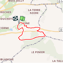
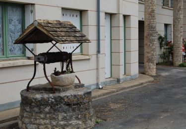
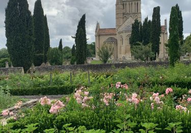
Circuit proposé par la mairie de Saint-Léger-de-la-Martinière et par le Syndicat Mixte du Pays Mellois. Départ de la fontaine de Mareuil. Retrouvez le circuit sur le site de la mairie de Saint-Léger-de-la-Martinière
Plaatsbepaling
Land:
France
Regio :
Nieuw-Aquitanië
Departement/Provincie :
Deux-Sèvres
Gemeente :
Melle
Locatie:
Saint-Léger-de-la-Martinière
Vertrek:(Dec)
Vertrek:(UTM)
723847 ; 5123654 (30T) N.
Opmerkingen
Wandeltochten in de omgeving
![Tocht Stappen Melle - JFT YB Etape8 5-5-2014 - Photo](https://media.geolcdn.com/t/375/260/ext.jpg?maxdim=2&url=https%3A%2F%2Fservices.sitytrail.com%2FGeolivesWS%2FDownloadMedia.ashx%3FTrailID%3D274241%26Media%3Dfix__20140505143257.jpg)
![Stappen Stappen](https://static1.geolcdn.com/sitytour/trail-icons/101.png)
JFT YB Etape8 5-5-2014
Stappen
Medium
Melle,
Nieuw-Aquitanië,
Deux-Sèvres,
France
![](/images/other/stat-length.png)
35 km | 38 km-effort
7h 49min
![](https://static1.geolcdn.com/siteimages/upload/files/16400158638029165_repeat_loop_refresh_sync_direction_icon.png)
Neen
![Tocht Stappen Melle - Le Bois de Melle - Saint Léger de la Martinière - Photo](https://media.geolcdn.com/t/375/260/ext.jpg?maxdim=2&url=https%3A%2F%2Fservices.sitytrail.com%2FGeolivesWS%2FDownloadMedia.ashx%3FTrailID%3D106063%26Media%3D10208_5.jpg)
![Stappen Stappen](https://static1.geolcdn.com/sitytour/trail-icons/101.png)
Le Bois de Melle - Saint Léger de la Martinière
Stappen
Gemakkelijk
Melle,
Nieuw-Aquitanië,
Deux-Sèvres,
France
![](/images/other/stat-length.png)
6,5 km | 7,3 km-effort
1h 40min
![](https://static1.geolcdn.com/siteimages/upload/files/16400158638029165_repeat_loop_refresh_sync_direction_icon.png)
Ja
![Tocht Stappen Melle - VOIE DE TOURS Melle - Aulnay les Saintonges - Photo](https://media.geolcdn.com/t/375/260/374ab43c-8e15-433b-89b0-95926ee49bad.jpg&format=jpg&maxdim=2)
![Stappen Stappen](https://static1.geolcdn.com/sitytour/trail-icons/101.png)
VOIE DE TOURS Melle - Aulnay les Saintonges
Stappen
Medium
Melle,
Nieuw-Aquitanië,
Deux-Sèvres,
France
![](/images/other/stat-length.png)
37 km | 41 km-effort
6h 47min
![](https://static1.geolcdn.com/siteimages/upload/files/16400158638029165_repeat_loop_refresh_sync_direction_icon.png)
Neen
![Tocht Stappen Melle - Le Bois de Melle - Photo](https://media.geolcdn.com/t/375/260/ext.jpg?maxdim=2&url=https%3A%2F%2Fstatic1.geolcdn.com%2Fsiteimages%2Fupload%2Ffiles%2F1553511878bg_sport_marche.png)
![Stappen Stappen](https://static1.geolcdn.com/sitytour/trail-icons/101.png)
Le Bois de Melle
Stappen
Heel gemakkelijk
Melle,
Nieuw-Aquitanië,
Deux-Sèvres,
France
![](/images/other/stat-length.png)
6,5 km | 7,3 km-effort
1h 38min
![](https://static1.geolcdn.com/siteimages/upload/files/16400158638029165_repeat_loop_refresh_sync_direction_icon.png)
Ja
![Tocht Stappen Melle - Les Bois de la Garde - Photo](https://media.geolcdn.com/t/375/260/ext.jpg?maxdim=2&url=https%3A%2F%2Fstatic1.geolcdn.com%2Fsiteimages%2Fupload%2Ffiles%2F1553511878bg_sport_marche.png)
![Stappen Stappen](https://static1.geolcdn.com/sitytour/trail-icons/101.png)
Les Bois de la Garde
Stappen
Heel gemakkelijk
Melle,
Nieuw-Aquitanië,
Deux-Sèvres,
France
![](/images/other/stat-length.png)
5 km | 5,6 km-effort
1h 13min
![](https://static1.geolcdn.com/siteimages/upload/files/16400158638029165_repeat_loop_refresh_sync_direction_icon.png)
Ja
![Tocht Stappen Marcillé - ghg - Photo](https://media.geolcdn.com/t/375/260/ext.jpg?maxdim=2&url=https%3A%2F%2Fstatic1.geolcdn.com%2Fsiteimages%2Fupload%2Ffiles%2F1553511878bg_sport_marche.png)
![Stappen Stappen](https://static1.geolcdn.com/sitytour/trail-icons/101.png)
ghg
Stappen
Medium
Marcillé,
Nieuw-Aquitanië,
Deux-Sèvres,
France
![](/images/other/stat-length.png)
9,1 km | 10,5 km-effort
1h 49min
![](https://static1.geolcdn.com/siteimages/upload/files/16400158638029165_repeat_loop_refresh_sync_direction_icon.png)
Ja
![Tocht Stappen Melle - melle - Photo](https://media.geolcdn.com/t/375/260/ext.jpg?maxdim=2&url=https%3A%2F%2Fstatic1.geolcdn.com%2Fsiteimages%2Fupload%2Ffiles%2F1553511878bg_sport_marche.png)
![Stappen Stappen](https://static1.geolcdn.com/sitytour/trail-icons/101.png)
melle
Stappen
Heel gemakkelijk
Melle,
Nieuw-Aquitanië,
Deux-Sèvres,
France
![](/images/other/stat-length.png)
11 km | 12,8 km-effort
2h 32min
![](https://static1.geolcdn.com/siteimages/upload/files/16400158638029165_repeat_loop_refresh_sync_direction_icon.png)
Ja
![Tocht Stappen Melle - marché - Photo](https://media.geolcdn.com/t/375/260/ext.jpg?maxdim=2&url=https%3A%2F%2Fstatic1.geolcdn.com%2Fsiteimages%2Fupload%2Ffiles%2F1553511878bg_sport_marche.png)
![Stappen Stappen](https://static1.geolcdn.com/sitytour/trail-icons/101.png)
marché
Stappen
Gemakkelijk
Melle,
Nieuw-Aquitanië,
Deux-Sèvres,
France
![](/images/other/stat-length.png)
4,4 km | 5 km-effort
49min
![](https://static1.geolcdn.com/siteimages/upload/files/16400158638029165_repeat_loop_refresh_sync_direction_icon.png)
Ja
![Tocht Paardrijden Lezay - Loup Garou - Photo](https://media.geolcdn.com/t/375/260/ext.jpg?maxdim=2&url=https%3A%2F%2Fstatic1.geolcdn.com%2Fsiteimages%2Fupload%2Ffiles%2F1524743154cheval.jpg)
![Paardrijden Paardrijden](https://static1.geolcdn.com/sitytour/trail-icons/301.png)
Loup Garou
Paardrijden
Moeilijk
Lezay,
Nieuw-Aquitanië,
Deux-Sèvres,
France
![](/images/other/stat-length.png)
31 km | 35 km-effort
5h 22min
![](https://static1.geolcdn.com/siteimages/upload/files/16400158638029165_repeat_loop_refresh_sync_direction_icon.png)
Neen