![](/images/other/stat-length.png)
![Tocht Stappen Loisieux - Le passage du Molard Grandjean, Bois de Glaize - Photo](https://media.geolcdn.com/t/1900/400/ext.pjpeg?maxdim=2&url=https%3A%2F%2Fservices.sitytrail.com%2FGeolivesWS%2FDownloadMedia.ashx%3FTrailID%3D105958%26Media%3D10030_1.jpg)
Le passage du Molard Grandjean, Bois de Glaize
tracegps
Gebruiker
![Lengte](/images/other/stat-length.png)
![Max. hoogte](https://static1.geolcdn.com/siteimages/upload/files/1508320355ic_sort_altitude_max_24dp.png)
![Positief hoogteverschil](https://static1.geolcdn.com/siteimages/upload/files/1508320355ic_sort_den_pos_24dp.png)
![Km-Effort](/images/other/stat-length.png)
![Min. hoogte](https://static1.geolcdn.com/siteimages/upload/files/1508320355ic_sort_altitude_min_24dp.png)
![Negatief hoogteverschil](https://static1.geolcdn.com/siteimages/upload/files/1508320355ic_sort_den_neg_24dp.png)
![Boucle](https://static1.geolcdn.com/siteimages/upload/files/16400158638029165_repeat_loop_refresh_sync_direction_icon.png)
![Stappen](https://static1.geolcdn.com/sitytour/trail-icons/101.png)
2h45
Moeilijkheid : Gemakkelijk
![Scan deze QR-code om de tocht te openen in de SityTrail-applicatie](https://capi.geolives.com/qq0zvz2zws4bq2lad0pu/sitytour/trails/105958/qr.png?size=200)
Gratisgps-wandelapplicatie
Over ons
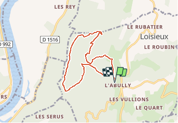
Tocht Stappen van 7,6 km beschikbaar op Auvergne-Rhône-Alpes, Savoie, Loisieux. Deze tocht wordt voorgesteld door tracegps.
Beschrijving
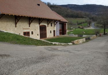
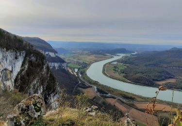
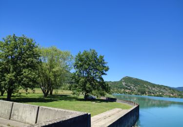
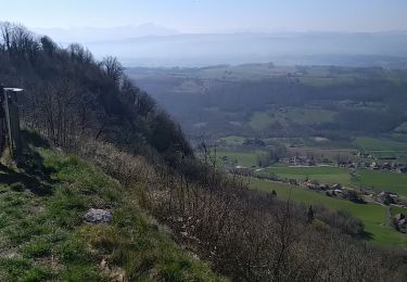
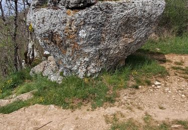
Cela fait des années que parcourant le Bois de Glaize en tous sens, des sentiers méconnus sous le Mont Tournier, ont à nouveau excité ma curiosité de ces lieux pourtant bien connus. Alors, je les ai suivi les traces sans préjugé, pour avec méthode, les relever à l'aide d'un récepteur GPS. Ainsi, après plusieurs retours en ces lieux appréciés, une nouvelle randonnée a pu être dessinée, passant par le Passage du Molard Grandjean et une descente improbable vers le site de la Chapelle Saint Martin. Le retour déjà décrit à plusieurs reprises, emprunte les paysages en canyons escarpés, caractéristiques du Bois de Glaize. Description complète sur sentier-nature.com : Le passage du Molard Grandjean, Bois de Glaize Avertissement [Orientation 1/3].
Plaatsbepaling
Opmerkingen
Wandeltochten in de omgeving
![Tocht Paardrijden Traize - 202405 Traize boucle 14km - Photo](https://media.geolcdn.com/t/375/260/ffd07fb0-aa84-4dca-b043-f7566568fc44.jpg&format=jpg&maxdim=2)
![Paardrijden Paardrijden](https://static1.geolcdn.com/sitytour/trail-icons/301.png)
Paardrijden
![](/images/other/stat-length.png)
![](https://static1.geolcdn.com/siteimages/upload/files/16400158638029165_repeat_loop_refresh_sync_direction_icon.png)
![Tocht Stappen Saint-Genix-les-Villages - 73_gresin_montTournier_18km_630 - Photo](https://media.geolcdn.com/t/375/260/8cc10b7c-be8e-494b-84e7-db8c7dc80b3c.jpg&format=jpg&maxdim=2)
![Stappen Stappen](https://static1.geolcdn.com/sitytour/trail-icons/101.png)
Stappen
![](/images/other/stat-length.png)
![](https://static1.geolcdn.com/siteimages/upload/files/16400158638029165_repeat_loop_refresh_sync_direction_icon.png)
![Tocht Paardrijden Peyrieu - peyrieu Izieu valide cavaliersp - Photo](https://media.geolcdn.com/t/375/260/2c32351f-e06a-4a02-927a-937d3ed0c61b.jpg&format=jpg&maxdim=2)
![Paardrijden Paardrijden](https://static1.geolcdn.com/sitytour/trail-icons/301.png)
Paardrijden
![](/images/other/stat-length.png)
![](https://static1.geolcdn.com/siteimages/upload/files/16400158638029165_repeat_loop_refresh_sync_direction_icon.png)
![Tocht Stappen Saint-Genix-les-Villages - Mont Tournier - Photo](https://media.geolcdn.com/t/375/260/ca4047a9-59c8-4dcf-93d3-127eea8f1a84.jpg&format=jpg&maxdim=2)
![Stappen Stappen](https://static1.geolcdn.com/sitytour/trail-icons/101.png)
Stappen
![](/images/other/stat-length.png)
![](https://static1.geolcdn.com/siteimages/upload/files/16400158638029165_repeat_loop_refresh_sync_direction_icon.png)
![Tocht Paardrijden Champagneux - 202206 boucle Gourjux - Photo](https://media.geolcdn.com/t/375/260/c8713771-86f9-46ed-8bc5-7397cec70731.jpg&format=jpg&maxdim=2)
![Paardrijden Paardrijden](https://static1.geolcdn.com/sitytour/trail-icons/301.png)
Paardrijden
![](/images/other/stat-length.png)
![](https://static1.geolcdn.com/siteimages/upload/files/16400158638029165_repeat_loop_refresh_sync_direction_icon.png)
![Tocht Stappen Saint-Genix-les-Villages - le monts tournier - Photo](https://media.geolcdn.com/t/375/260/73dd6fc7-d7b7-4eb8-83b7-c2dd469235a5.jpg&format=jpg&maxdim=2)
![Stappen Stappen](https://static1.geolcdn.com/sitytour/trail-icons/101.png)
Stappen
![](/images/other/stat-length.png)
![](https://static1.geolcdn.com/siteimages/upload/files/16400158638029165_repeat_loop_refresh_sync_direction_icon.png)
![Tocht Stappen Saint-Pierre-d'Alvey - Mont Tournier pierre vire-28-04-23 - Photo](https://media.geolcdn.com/t/375/260/14a8e7f2-9f03-486d-bc29-98ff8b33499d.jpg&format=jpg&maxdim=2)
![Stappen Stappen](https://static1.geolcdn.com/sitytour/trail-icons/101.png)
Stappen
![](/images/other/stat-length.png)
![](https://static1.geolcdn.com/siteimages/upload/files/16400158638029165_repeat_loop_refresh_sync_direction_icon.png)
![Tocht Mountainbike Peyrieu - Sur Fays - Photo](https://media.geolcdn.com/t/375/260/bba9d891-7509-4cec-84db-7eb740a87a92.jpg&format=jpg&maxdim=2)
![Mountainbike Mountainbike](https://static1.geolcdn.com/sitytour/trail-icons/202.png)
Mountainbike
![](/images/other/stat-length.png)
![](https://static1.geolcdn.com/siteimages/upload/files/16400158638029165_repeat_loop_refresh_sync_direction_icon.png)
![Tocht Paardrijden Saint-Genix-les-Villages - 201106 boucle StMauriceRotherens - Photo](https://media.geolcdn.com/t/375/260/c9374c5a-470a-410c-8894-565c5f062cd7.jpg&format=jpg&maxdim=2)
![Paardrijden Paardrijden](https://static1.geolcdn.com/sitytour/trail-icons/301.png)
Paardrijden
![](/images/other/stat-length.png)
![](https://static1.geolcdn.com/siteimages/upload/files/16400158638029165_repeat_loop_refresh_sync_direction_icon.png)