![](/images/other/stat-length.png)
![Tocht Stappen Loguivy-Plougras - Loguivy-Plougras 13Kms - Photo](https://media.geolcdn.com/t/1900/400/ext.pjpeg?maxdim=2&url=https%3A%2F%2Fservices.sitytrail.com%2FGeolivesWS%2FDownloadMedia.ashx%3FTrailID%3D105908%26Media%3D9926_4.jpg)
Loguivy-Plougras 13Kms
tracegps
Gebruiker
![Lengte](/images/other/stat-length.png)
Lengte
13,6 km
![Max. hoogte](https://static1.geolcdn.com/siteimages/upload/files/1508320355ic_sort_altitude_max_24dp.png)
Max. hoogte
208 m
![Positief hoogteverschil](https://static1.geolcdn.com/siteimages/upload/files/1508320355ic_sort_den_pos_24dp.png)
Positief hoogteverschil
213 m
![Km-Effort](/images/other/stat-length.png)
Km-Effort
16,5 km
![Min. hoogte](https://static1.geolcdn.com/siteimages/upload/files/1508320355ic_sort_altitude_min_24dp.png)
Min. hoogte
147 m
![Negatief hoogteverschil](https://static1.geolcdn.com/siteimages/upload/files/1508320355ic_sort_den_neg_24dp.png)
Negatief hoogteverschil
213 m
![Boucle](https://static1.geolcdn.com/siteimages/upload/files/16400158638029165_repeat_loop_refresh_sync_direction_icon.png)
Boucle
Ja
Datum van aanmaak :
2014-12-10 00:00:00.0
Laatste wijziging :
2014-12-10 00:00:00.0
![Stappen](https://static1.geolcdn.com/sitytour/trail-icons/101.png)
3h30
Moeilijkheid : Moeilijk
![Scan deze QR-code om de tocht te openen in de SityTrail-applicatie](https://capi.geolives.com/qq0zvz2zws4bq2lad0pu/sitytour/trails/105908/qr.png?size=200)
Gratisgps-wandelapplicatie
Over ons
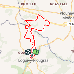
Tocht Stappen van 13,6 km beschikbaar op Bretagne, Côtes-d'Armor, Loguivy-Plougras. Deze tocht wordt voorgesteld door tracegps.
Beschrijving
Circuit proposé par l'Association Henchou Don Lanvaeleg. Départ du Bourg de Loguivy-Plougras. Ce circuit a été créé pour l’édition 2010 de An Dro hag Distro (Journée de la marche pour tous en pays de Trégor).
Plaatsbepaling
Land:
France
Regio :
Bretagne
Departement/Provincie :
Côtes-d'Armor
Gemeente :
Loguivy-Plougras
Locatie:
Unknown
Vertrek:(Dec)
Vertrek:(UTM)
464039 ; 5374444 (30U) N.
Opmerkingen
Wandeltochten in de omgeving
![Tocht Te voet Loguivy-Plougras - 2022-04-02_21h02m51_SityTrail - 2870303 - botsorhelx22072021 - Photo](https://media.geolcdn.com/t/375/260/ext.jpg?maxdim=2&url=https%3A%2F%2Fstatic1.geolcdn.com%2Fsiteimages%2Fupload%2Ffiles%2F1545311037marcheuse_200dpi.jpg)
![Te voet Te voet](https://static1.geolcdn.com/sitytour/trail-icons/100.png)
2022-04-02_21h02m51_SityTrail - 2870303 - botsorhelx22072021
Te voet
Moeilijk
Loguivy-Plougras,
Bretagne,
Côtes-d'Armor,
France
![](/images/other/stat-length.png)
26 km | 32 km-effort
7h 20min
![](https://static1.geolcdn.com/siteimages/upload/files/16400158638029165_repeat_loop_refresh_sync_direction_icon.png)
Neen
![Tocht Stappen Loguivy-Plougras - Le Dresnay. Botsorhel - Photo](https://media.geolcdn.com/t/375/260/ext.jpg?maxdim=2&url=https%3A%2F%2Fstatic1.geolcdn.com%2Fsiteimages%2Fupload%2Ffiles%2F1553511878bg_sport_marche.png)
![Stappen Stappen](https://static1.geolcdn.com/sitytour/trail-icons/101.png)
Le Dresnay. Botsorhel
Stappen
Zeer moeilijk
Loguivy-Plougras,
Bretagne,
Côtes-d'Armor,
France
![](/images/other/stat-length.png)
27 km | 33 km-effort
9h 39min
![](https://static1.geolcdn.com/siteimages/upload/files/16400158638029165_repeat_loop_refresh_sync_direction_icon.png)
Neen
![Tocht Stappen Loguivy-Plougras - Botsorhel.22072021 - Photo](https://media.geolcdn.com/t/375/260/ext.jpg?maxdim=2&url=https%3A%2F%2Fstatic1.geolcdn.com%2Fsiteimages%2Fupload%2Ffiles%2F1553511878bg_sport_marche.png)
![Stappen Stappen](https://static1.geolcdn.com/sitytour/trail-icons/101.png)
Botsorhel.22072021
Stappen
Zeer moeilijk
Loguivy-Plougras,
Bretagne,
Côtes-d'Armor,
France
![](/images/other/stat-length.png)
26 km | 32 km-effort
8h 31min
![](https://static1.geolcdn.com/siteimages/upload/files/16400158638029165_repeat_loop_refresh_sync_direction_icon.png)
Neen
![Tocht Te voet Loguivy-Plougras - Dresnay-Guerlesquin Kerlouerien - Photo](https://media.geolcdn.com/t/375/260/ext.jpg?maxdim=2&url=https%3A%2F%2Fstatic1.geolcdn.com%2Fsiteimages%2Fupload%2Ffiles%2F1545311037marcheuse_200dpi.jpg)
![Te voet Te voet](https://static1.geolcdn.com/sitytour/trail-icons/100.png)
Dresnay-Guerlesquin Kerlouerien
Te voet
Medium
Loguivy-Plougras,
Bretagne,
Côtes-d'Armor,
France
![](/images/other/stat-length.png)
23 km | 28 km-effort
6h 26min
![](https://static1.geolcdn.com/siteimages/upload/files/16400158638029165_repeat_loop_refresh_sync_direction_icon.png)
Neen
![Tocht Stappen Plounévez-Moëdec - Plougras - Photo](https://media.geolcdn.com/t/375/260/ext.jpg?maxdim=2&url=https%3A%2F%2Fstatic1.geolcdn.com%2Fsiteimages%2Fupload%2Ffiles%2F1553511878bg_sport_marche.png)
![Stappen Stappen](https://static1.geolcdn.com/sitytour/trail-icons/101.png)
Plougras
Stappen
Plounévez-Moëdec,
Bretagne,
Côtes-d'Armor,
France
![](/images/other/stat-length.png)
9,5 km | 11,7 km-effort
2h 15min
![](https://static1.geolcdn.com/siteimages/upload/files/16400158638029165_repeat_loop_refresh_sync_direction_icon.png)
Neen
![Tocht Paard Loguivy-Plougras - 6vieuxmarche-dresnay 27 - Photo](https://media.geolcdn.com/t/375/260/ext.jpg?maxdim=2&url=https%3A%2F%2Fstatic1.geolcdn.com%2Fsiteimages%2Fupload%2Ffiles%2F1524743154cheval.jpg)
![Paard Paard](https://static1.geolcdn.com/sitytour/trail-icons/300.png)
6vieuxmarche-dresnay 27
Paard
Heel gemakkelijk
Loguivy-Plougras,
Bretagne,
Côtes-d'Armor,
France
![](/images/other/stat-length.png)
27 km | 34 km-effort
4h 4min
![](https://static1.geolcdn.com/siteimages/upload/files/16400158638029165_repeat_loop_refresh_sync_direction_icon.png)
Neen