Tocht Stappen Plouégat-Guérand - Sent Douron - Plouégat-Guérand - Photo

Sent Douron - Plouégat-Guérand

 tracegps
tracegps

Gebruiker

© OpenStreetMap contributors
Lengte
Lengte
13,2 km
Max. hoogte
Max. hoogte
140 m
Positief hoogteverschil
189 m
Km-Effort
Km-Effort  
15,7 km
Min. hoogte
Min. hoogte
32 m
Negatief hoogteverschil
188 m
Boucle
Boucle
Ja
Datum van aanmaak :
2014-12-10 00:00:00.0
Laatste wijziging :
2014-12-10 00:00:00.0

(1 Bericht)

Stappen
Stappen
3h19
Moeilijkheid : Moeilijk

Scan deze QR-code om de tocht te openen in de SityTrail-applicatie

Gratisgps-wandelapplicatie

Logo SityTrail SityTrail

IGN / Geografische instituten

SityTrail uit de App Store downloaden SityTrail uit Google Play downloaden

Logo SityTrail SityTrail World

De wereld gaat voor u open

SityTrail uit de App Store downloaden SityTrail uit Google Play downloaden SityTrail op Huawei AppGallery downloaden

Over ons

Tocht Stappen van 13,2 km beschikbaar op Bretagne, Finistère, Plouégat-Guérand. Deze tocht wordt voorgesteld door tracegps.

Beschrijving

Circuit proposé par l'Association Henchou Don Lanvaeleg. Départ de l’église de Plouégat-Guérand. Au pays des cerisiers, balade en sous bois dans le Trégor Finistérien.

Hoogteprofiel

Foto's

Plaatsbepaling

Land:
France
Regio :
Bretagne
Departement/Provincie :
Finistère
Gemeente :
Plouégat-Guérand
Locatie:
Unknown
Vertrek:(Dec)
Vertrek:(UTM)
450359 ; 5385495 (30U) N.

Opmerkingen

Gelieve in te loggen om een commentaar of een beoordeling achter te laten


bouclé de St-Mars ch. à Lonperrier


Wandeltochten in de omgeving

Tocht Mountainbike Plestin-les-Grèves - Circuit des chapelles, coté terre - Plestin-les-Grèves - Photo
Mountainbike
tracegps

Mountainbike

Medium
(1)
Plestin-les-Grèves, Bretagne, Côtes-d'Armor, France
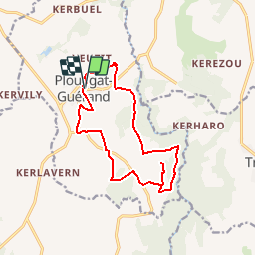
17,1 km | 20 km-effort
2h 0min
Ja
Tocht Stappen Plestin-les-Grèves - Circuit de la chapelle Sainte Anne - Plestin-les-Grèves - Photo
Stappen
tracegps

Stappen

Gemakkelijk
Plestin-les-Grèves, Bretagne, Côtes-d'Armor, France
6,9 km | 8,4 km-effort
1h 40min
Ja
Tocht Stappen Plestin-les-Grèves - Circuit de la chapelle St Jagut - Plestin-les-Grèves - Photo
Stappen
tracegps

Stappen

Gemakkelijk
Plestin-les-Grèves, Bretagne, Côtes-d'Armor, France
7,9 km | 9,2 km-effort
2h 0min
Ja
Tocht Mountainbike Plestin-les-Grèves - Circuit des chapelles, coté mer - Plestin-les-Grèves - Photo
Mountainbike
tracegps

Mountainbike

Gemakkelijk
Plestin-les-Grèves, Bretagne, Côtes-d'Armor, France
9,6 km | 11,2 km-effort
1h 0min
Ja
Tocht Te voet Plestin-les-Grèves - GR 34 B - Photo
Te voet
PRO

Te voet

Gemakkelijk
Plestin-les-Grèves, Bretagne, Côtes-d'Armor, France
3,6 km | 4,2 km-effort
57min
Neen
Tocht Stappen Plestin-les-Grèves - Circuit de la chapelle St Roch - Plestin-les-Grèves - Photo
Stappen
tracegps

Stappen

Gemakkelijk
Plestin-les-Grèves, Bretagne, Côtes-d'Armor, France
5,8 km | 7,2 km-effort
1h 30min
Ja
Tocht Stappen Plouégat-Guérand - Plouegat Guerrand - Photo
Stappen
0658294C

Stappen

Moeilijk
Plouégat-Guérand, Bretagne, Finistère, France
10,4 km | 12,5 km-effort
2h 52min
Ja
Tocht Andere activiteiten Plestin-les-Grèves - Douron - Photo
Andere activiteiten
filite

Andere activiteiten

Heel gemakkelijk
Plestin-les-Grèves, Bretagne, Côtes-d'Armor, France
12,6 km | 14,8 km-effort
4h 40min
Ja
Tocht Stappen Lanmeur - Le petit train - Photo
Stappen
jh.daniel

Stappen

Gemakkelijk
Lanmeur, Bretagne, Finistère, France
9,3 km | 10,4 km-effort
2h 17min
Ja


Sluiten
Mijn abonnementen