![](/images/other/stat-length.png)
![Tocht Mountainbike Fermanville - Fermanville - Le Vast - Photo](https://media.geolcdn.com/t/1900/400/ext.pjpeg?maxdim=2&url=https%3A%2F%2Fservices.sitytrail.com%2FGeolivesWS%2FDownloadMedia.ashx%3FTrailID%3D105842%26Media%3D9808_1.jpg)
Fermanville - Le Vast
tracegps
Gebruiker
![Lengte](/images/other/stat-length.png)
Lengte
32 km
![Max. hoogte](https://static1.geolcdn.com/siteimages/upload/files/1508320355ic_sort_altitude_max_24dp.png)
Max. hoogte
139 m
![Positief hoogteverschil](https://static1.geolcdn.com/siteimages/upload/files/1508320355ic_sort_den_pos_24dp.png)
Positief hoogteverschil
413 m
![Km-Effort](/images/other/stat-length.png)
Km-Effort
37 km
![Min. hoogte](https://static1.geolcdn.com/siteimages/upload/files/1508320355ic_sort_altitude_min_24dp.png)
Min. hoogte
2 m
![Negatief hoogteverschil](https://static1.geolcdn.com/siteimages/upload/files/1508320355ic_sort_den_neg_24dp.png)
Negatief hoogteverschil
443 m
![Boucle](https://static1.geolcdn.com/siteimages/upload/files/16400158638029165_repeat_loop_refresh_sync_direction_icon.png)
Boucle
Neen
Datum van aanmaak :
2014-12-10 00:00:00.0
Laatste wijziging :
2014-12-10 00:00:00.0
![Mountainbike](https://static1.geolcdn.com/sitytour/trail-icons/202.png)
2h30
Moeilijkheid : Moeilijk
![Scan deze QR-code om de tocht te openen in de SityTrail-applicatie](https://capi.geolives.com/qq0zvz2zws4bq2lad0pu/sitytour/trails/105842/qr.png?size=200)
Gratisgps-wandelapplicatie
Over ons
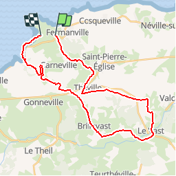
Tocht Mountainbike van 32 km beschikbaar op Normandië, Manche, Fermanville. Deze tocht wordt voorgesteld door tracegps.
Beschrijving
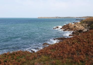
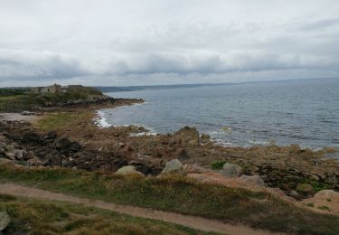
De Fermanville jusqu'à la vallée de la Saire à Le Vast. Une dernière descente dans un bois pour nous ramener au niveau de la mer. Très technique mais de toute beauté et pour finir 2km en front de mer, magnifique!
Plaatsbepaling
Land:
France
Regio :
Normandië
Departement/Provincie :
Manche
Gemeente :
Fermanville
Locatie:
Unknown
Vertrek:(Dec)
Vertrek:(UTM)
611577 ; 5504710 (30U) N.
Opmerkingen
Wandeltochten in de omgeving
![Tocht Stappen Fermanville - La Vallée des Moulins - Photo](https://media.geolcdn.com/t/375/260/c70b4e51-995e-4d7a-bf0b-a8ccbeea7f50.jpg&format=jpg&maxdim=2)
![Stappen Stappen](https://static1.geolcdn.com/sitytour/trail-icons/101.png)
La Vallée des Moulins
Stappen
Medium
Fermanville,
Normandië,
Manche,
France
![](/images/other/stat-length.png)
9,1 km | 11 km-effort
2h 30min
![](https://static1.geolcdn.com/siteimages/upload/files/16400158638029165_repeat_loop_refresh_sync_direction_icon.png)
Ja
![Tocht Stappen Fermanville - Fermanville - Photo](https://media.geolcdn.com/t/375/260/3f291961-9aaf-4ea1-a127-c889045f6865.jpg&format=jpg&maxdim=2)
![Stappen Stappen](https://static1.geolcdn.com/sitytour/trail-icons/101.png)
![Tocht Stappen Fermanville - Fermanville / Maupertus - Photo](https://media.geolcdn.com/t/375/260/260bea8b-c2a4-4fce-9632-c73c3b6e2ace.jpeg&format=jpg&maxdim=2)
![Stappen Stappen](https://static1.geolcdn.com/sitytour/trail-icons/101.png)
Fermanville / Maupertus
Stappen
Medium
Fermanville,
Normandië,
Manche,
France
![](/images/other/stat-length.png)
21 km | 26 km-effort
3h 36min
![](https://static1.geolcdn.com/siteimages/upload/files/16400158638029165_repeat_loop_refresh_sync_direction_icon.png)
Ja
![Tocht Stappen Fermanville - 50 Autour du Cap LEVI 5km - Photo](https://media.geolcdn.com/t/375/260/45b22b03-bec5-41a2-a7f6-e496526d73d7.jpg&format=jpg&maxdim=2)
![Stappen Stappen](https://static1.geolcdn.com/sitytour/trail-icons/101.png)
50 Autour du Cap LEVI 5km
Stappen
Heel gemakkelijk
Fermanville,
Normandië,
Manche,
France
![](/images/other/stat-length.png)
5,1 km | 5,6 km-effort
1h 22min
![](https://static1.geolcdn.com/siteimages/upload/files/16400158638029165_repeat_loop_refresh_sync_direction_icon.png)
Ja
![Tocht Stappen Fermanville - cap levi - Photo](https://media.geolcdn.com/t/375/260/ext.jpg?maxdim=2&url=https%3A%2F%2Fstatic1.geolcdn.com%2Fsiteimages%2Fupload%2Ffiles%2F1553511878bg_sport_marche.png)
![Stappen Stappen](https://static1.geolcdn.com/sitytour/trail-icons/101.png)
cap levi
Stappen
Gemakkelijk
(1)
Fermanville,
Normandië,
Manche,
France
![](/images/other/stat-length.png)
4,4 km | 4,8 km-effort
1h 3min
![](https://static1.geolcdn.com/siteimages/upload/files/16400158638029165_repeat_loop_refresh_sync_direction_icon.png)
Ja
![Tocht Stappen Fermanville - fermanville 12042019 - Photo](https://media.geolcdn.com/t/375/260/ext.jpg?maxdim=2&url=https%3A%2F%2Fstatic1.geolcdn.com%2Fsiteimages%2Fupload%2Ffiles%2F1553511878bg_sport_marche.png)
![Stappen Stappen](https://static1.geolcdn.com/sitytour/trail-icons/101.png)
fermanville 12042019
Stappen
Heel gemakkelijk
(1)
Fermanville,
Normandië,
Manche,
France
![](/images/other/stat-length.png)
9,3 km | 11,8 km-effort
2h 4min
![](https://static1.geolcdn.com/siteimages/upload/files/16400158638029165_repeat_loop_refresh_sync_direction_icon.png)
Ja
![Tocht Stappen Fermanville - boucle cap Lévy plage mondree - Photo](https://media.geolcdn.com/t/375/260/ext.jpg?maxdim=2&url=https%3A%2F%2Fstatic1.geolcdn.com%2Fsiteimages%2Fupload%2Ffiles%2F1553511878bg_sport_marche.png)
![Stappen Stappen](https://static1.geolcdn.com/sitytour/trail-icons/101.png)
boucle cap Lévy plage mondree
Stappen
Heel gemakkelijk
(1)
Fermanville,
Normandië,
Manche,
France
![](/images/other/stat-length.png)
7 km | 8 km-effort
1h 48min
![](https://static1.geolcdn.com/siteimages/upload/files/16400158638029165_repeat_loop_refresh_sync_direction_icon.png)
Ja
![Tocht Mountainbike Théville - Petite balade dans le val de Saire - Théville - Photo](https://media.geolcdn.com/t/375/260/ext.jpg?maxdim=2&url=https%3A%2F%2Fservices.sitytrail.com%2FGeolivesWS%2FDownloadMedia.ashx%3FTrailID%3D215112%26Media%3D15697_2.jpg)
![Mountainbike Mountainbike](https://static1.geolcdn.com/sitytour/trail-icons/202.png)
Petite balade dans le val de Saire - Théville
Mountainbike
Medium
Théville,
Normandië,
Manche,
France
![](/images/other/stat-length.png)
31 km | 37 km-effort
4h 49min
![](https://static1.geolcdn.com/siteimages/upload/files/16400158638029165_repeat_loop_refresh_sync_direction_icon.png)
Ja
![Tocht Stappen Maupertus-sur-Mer - Anse du Brick ET Les Landes - Photo](https://media.geolcdn.com/t/375/260/ext.jpg?maxdim=2&url=https%3A%2F%2Fstatic1.geolcdn.com%2Fsiteimages%2Fupload%2Ffiles%2F1553511878bg_sport_marche.png)
![Stappen Stappen](https://static1.geolcdn.com/sitytour/trail-icons/101.png)
Anse du Brick ET Les Landes
Stappen
Medium
Maupertus-sur-Mer,
Normandië,
Manche,
France
![](/images/other/stat-length.png)
14 km | 18 km-effort
3h 56min
![](https://static1.geolcdn.com/siteimages/upload/files/16400158638029165_repeat_loop_refresh_sync_direction_icon.png)
Ja