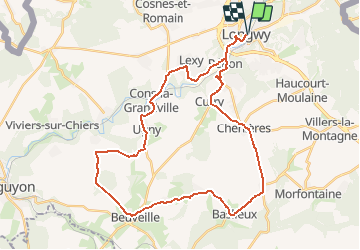
![](/images/other/stat-length.png)
![Tocht Fiets Longwy - Longwy - Le pays haut - Photo](https://media.geolcdn.com/t/1900/400/ext.pjpeg?maxdim=2&url=https%3A%2F%2Fstatic1.geolcdn.com%2Fsiteimages%2Fupload%2Ffiles%2F1524743154velo.jpg)
Longwy - Le pays haut
papadoc
Gebruiker
![Lengte](/images/other/stat-length.png)
![Max. hoogte](https://static1.geolcdn.com/siteimages/upload/files/1508320355ic_sort_altitude_max_24dp.png)
![Positief hoogteverschil](https://static1.geolcdn.com/siteimages/upload/files/1508320355ic_sort_den_pos_24dp.png)
![Km-Effort](/images/other/stat-length.png)
![Min. hoogte](https://static1.geolcdn.com/siteimages/upload/files/1508320355ic_sort_altitude_min_24dp.png)
![Negatief hoogteverschil](https://static1.geolcdn.com/siteimages/upload/files/1508320355ic_sort_den_neg_24dp.png)
![Boucle](https://static1.geolcdn.com/siteimages/upload/files/16400158638029165_repeat_loop_refresh_sync_direction_icon.png)
![Fiets](https://static1.geolcdn.com/sitytour/trail-icons/200.png)
2h34
Moeilijkheid : Gemakkelijk
![Scan deze QR-code om de tocht te openen in de SityTrail-applicatie](https://capi.geolives.com/qq0zvz2zws4bq2lad0pu/sitytour/trails/1057117/qr.png?size=200)
Gratisgps-wandelapplicatie
Over ons
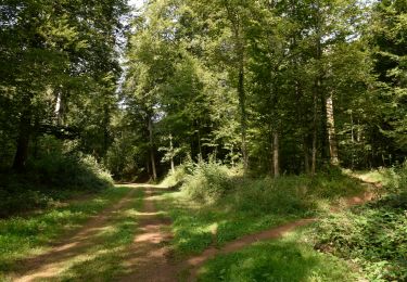
Tocht Fiets van 36 km beschikbaar op Grand Est, Meurthe-et-Moselle, Longwy. Deze tocht wordt voorgesteld door papadoc.
Beschrijving
https://veloenfrance.fr
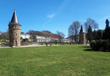
Longwy. Parmi les nombreux ouvrages de Vauban, Longwy fait partie des 9 villes construites « ex-nihilo » (à partir de rien) et qui traduisent le mieux sa conception de la ville idéale. C'est, entre autres, cette particularité qui a valu à la place forte de Longwy de faire partie du Réseau des Sites Majeurs de Vauban, inscrit sur la liste du patrimoine mondial par l’UNESCO. Les émaux. Créée en 1798, la faïencerie produit à l'origine uniquement des services de table et de toilette. À partir de 1835, elle s'ouvre à de nouvelles techniques et de nouveaux styles. C'est ainsi que, vers 1872, les fameux émaux cernés sur faïence voient le jour. Reflets des modes depuis le XIXe siècle, ces pièces d'exception, fruit d'un savoir-faire unique au monde, sont toujours produites par 5 manufacturiers à découvrir dans « la cité des émaux ». Le Fort de Fermont. Situé au cœur du Pays-Haut Lorrain, entre Longwy et Longuyon, le Fort de Fermont et son nouveau musée constituent le site de référence pour découvrir la Ligne Maginot. En plus de deux heures à 30 mètres sous terre, tantôt à pied, tantôt en train électrique, vous découvrirez un ouvrage d'artillerie de la Ligne Maginot, resté authentique avec ses équipements, ses organisations souterraines et son armement. Un circuit extérieur vous permettra de découvrir les autres blocs de l’ouvrage.
Plaatsbepaling
Opmerkingen
Wandeltochten in de omgeving
![Tocht Stappen Musson - RB-Lu-16 - Un sentier sans frontière - Photo](https://media.geolcdn.com/t/375/260/ext.jpg?maxdim=2&url=https%3A%2F%2Fservices.sitytrail.com%2FGeolivesWS%2FDownloadMedia.ashx%3FTrailID%3D179622%26Media%3D9895405c-6b98-4c01-8e3a-1e91cb98018a.jpg)
![Stappen Stappen](https://static1.geolcdn.com/sitytour/trail-icons/101.png)
Stappen
![](/images/other/stat-length.png)
![](https://static1.geolcdn.com/siteimages/upload/files/16400158638029165_repeat_loop_refresh_sync_direction_icon.png)
![Tocht Te voet Musson - Natuurreservaat van Musson - Photo](https://media.geolcdn.com/t/375/260/ext.jpg?maxdim=2&url=https%3A%2F%2Fpivotmedia.tourismewallonie.be%2FOTH-A0-006F-0GN7%2FOTH-A0-006F-0GN7.jpg)
![Te voet Te voet](https://static1.geolcdn.com/sitytour/trail-icons/100.png)
Te voet
![](/images/other/stat-length.png)
![](https://static1.geolcdn.com/siteimages/upload/files/16400158638029165_repeat_loop_refresh_sync_direction_icon.png)
![Tocht Stappen Aubange - GG2-Lu-33_Halanzy-Messancy (2021-11-04) - Photo](https://media.geolcdn.com/t/375/260/9d50722e-12e0-424a-b4f8-252d1e9dd93c.jpg&format=jpg&maxdim=2)
![Stappen Stappen](https://static1.geolcdn.com/sitytour/trail-icons/101.png)
Stappen
![](/images/other/stat-length.png)
![](https://static1.geolcdn.com/siteimages/upload/files/16400158638029165_repeat_loop_refresh_sync_direction_icon.png)
![Tocht Stappen Aubange - HALANZY Sentier des Mines de Fer - Photo](https://media.geolcdn.com/t/375/260/ext.jpg?maxdim=2&url=https%3A%2F%2Fstatic1.geolcdn.com%2Fsiteimages%2Fupload%2Ffiles%2F1553511878bg_sport_marche.png)
![Stappen Stappen](https://static1.geolcdn.com/sitytour/trail-icons/101.png)
Stappen
![](/images/other/stat-length.png)
![](https://static1.geolcdn.com/siteimages/upload/files/16400158638029165_repeat_loop_refresh_sync_direction_icon.png)
![Tocht Stappen Musson - Musson. Natura 2000, des sites qui vanlent le détour ! Lx 12 - Photo](https://media.geolcdn.com/t/375/260/ext.jpg?maxdim=2&url=https%3A%2F%2Fservices.sitytrail.com%2FGeolivesWS%2FDownloadMedia.ashx%3FTrailID%3D178152%26Media%3Db39e3ef5-eb22-4ba7-849a-1aaa6279773d.jpg)
![Stappen Stappen](https://static1.geolcdn.com/sitytour/trail-icons/101.png)
Stappen
![](/images/other/stat-length.png)
![](https://static1.geolcdn.com/siteimages/upload/files/16400158638029165_repeat_loop_refresh_sync_direction_icon.png)
![Tocht Te voet Haucourt-Moulaine - Sentier du Beau Chêne - Photo](https://media.geolcdn.com/t/375/260/f060c4d5-b3a7-4872-84e5-b1f11835f082.jpeg&format=jpg&maxdim=2)
![Te voet Te voet](https://static1.geolcdn.com/sitytour/trail-icons/100.png)
Te voet
![](/images/other/stat-length.png)
![](https://static1.geolcdn.com/siteimages/upload/files/16400158638029165_repeat_loop_refresh_sync_direction_icon.png)
![Tocht Te voet Aubange - Le Bois Haut - Photo](https://media.geolcdn.com/t/375/260/65dbbb39-2d8e-4019-beff-8cd7fff5ae3f.jpeg&format=jpg&maxdim=2)
![Te voet Te voet](https://static1.geolcdn.com/sitytour/trail-icons/100.png)
Te voet
![](/images/other/stat-length.png)
![](https://static1.geolcdn.com/siteimages/upload/files/16400158638029165_repeat_loop_refresh_sync_direction_icon.png)
![Tocht Te voet Aubange - Het Bois Haut in Halanzy - Photo](https://media.geolcdn.com/t/375/260/ext.jpg?maxdim=2&url=https%3A%2F%2Fpivotmedia.tourismewallonie.be%2FOTH-A0-0067-0SQP%2FOTH-A0-0067-0SQP.jpg)
![Te voet Te voet](https://static1.geolcdn.com/sitytour/trail-icons/100.png)
Te voet
![](/images/other/stat-length.png)
![](https://static1.geolcdn.com/siteimages/upload/files/16400158638029165_repeat_loop_refresh_sync_direction_icon.png)
![Tocht Stappen Aubange - GG2-Lg-30_Méry-Nessonvaux (2021-11-23) - Photo](https://media.geolcdn.com/t/375/260/5e94f84f-130a-4d17-95c1-ed22e975ff47.jpg&format=jpg&maxdim=2)
![Stappen Stappen](https://static1.geolcdn.com/sitytour/trail-icons/101.png)
Stappen
![](/images/other/stat-length.png)
![](https://static1.geolcdn.com/siteimages/upload/files/16400158638029165_repeat_loop_refresh_sync_direction_icon.png)