Tocht Fiets Escot - Transpyrénéenne en cyclo - étape 3 - Escot à Luz Saint Sauveur - Photo

Transpyrénéenne en cyclo - étape 3 - Escot à Luz Saint Sauveur

 tracegps
tracegps

Gebruiker

© OpenStreetMap contributors
Lengte
Lengte
138 km
Max. hoogte
Max. hoogte
2097 m
Positief hoogteverschil
4438 m
Km-Effort
Km-Effort  
197 km
Min. hoogte
Min. hoogte
438 m
Negatief hoogteverschil
4389 m
Boucle
Boucle
Neen
Datum van aanmaak :
2014-12-10 00:00:00.0
Laatste wijziging :
2014-12-10 00:00:00.0

(0 Bericht)

Fiets
Fiets
10h30
Moeilijkheid : Moeilijk

Scan deze QR-code om de tocht te openen in de SityTrail-applicatie

Gratisgps-wandelapplicatie

Logo SityTrail SityTrail

IGN / Geografische instituten

SityTrail uit de App Store downloaden SityTrail uit Google Play downloaden

Logo SityTrail SityTrail World

De wereld gaat voor u open

SityTrail uit de App Store downloaden SityTrail uit Google Play downloaden SityTrail op Huawei AppGallery downloaden

Over ons

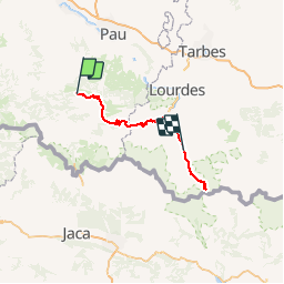
Tocht Fiets van 138 km beschikbaar op Nieuw-Aquitanië, Pyrénées-Atlantiques, Escot. Deze tocht wordt voorgesteld door tracegps.

Beschrijving

Etape 3/8 de la transpyrénéenne comportant une ascension supplémentaire en aller/retour vers le cirque de Troumouse.

Hoogteprofiel

Foto's

Plaatsbepaling

Land:
France
Regio :
Nieuw-Aquitanië
Departement/Provincie :
Pyrénées-Atlantiques
Gemeente :
Escot
Locatie:
Unknown
Vertrek:(Dec)
Vertrek:(UTM)
699858 ; 4772012 (30T) N.

Wandeltochten in de omgeving

Tocht Te voet Sarrance - SARRANCE / ACCOUS collecte numerique GR 653 10 - Photo
Te voet
GUIDE
marmotte65

Te voet

Gemakkelijk
Sarrance, Nieuw-Aquitanië, Pyrénées-Atlantiques, France
12,7 km | 17,3 km-effort
3h 57min
Neen
Tocht Stappen Bilhères - Pic des escurets 1440m en Aller-Retour - Photo
Stappen
HaschKnight

Stappen

Gemakkelijk
Bilhères, Nieuw-Aquitanië, Pyrénées-Atlantiques, France
4,8 km | 9,9 km-effort
2h 12min
Ja
Tocht Te voet Escot - Tour Bilboquet-Barescou asp01 - Photo
Te voet
GUIDE+

Te voet

Gemakkelijk
Escot, Nieuw-Aquitanië, Pyrénées-Atlantiques, France
9,9 km | 15,7 km-effort
3h 34min
Ja
Tocht Stappen Bilhères - BILHERES en OSSAU pic des escurets G3 - Photo
Stappen
GUIDE
marmotte65

Stappen

Medium
Bilhères, Nieuw-Aquitanië, Pyrénées-Atlantiques, France
6 km | 11,2 km-effort
2h 3min
Ja
Tocht Stappen Escot - escot le bilboquet G3 fait - Photo
Stappen
LouisROGER

Stappen

Heel gemakkelijk
Escot, Nieuw-Aquitanië, Pyrénées-Atlantiques, France
7,1 km | 12,5 km-effort
4h 57min
Neen
Tocht Trail Sarrance - Col Laundé - Photo
Trail
Anteus

Trail

Gemakkelijk
Sarrance, Nieuw-Aquitanië, Pyrénées-Atlantiques, France
5,6 km | 10,7 km-effort
1h 12min
Ja
Tocht Stappen Escot - Pic Roumendarès 1646m - Photo
Stappen
tracegps

Stappen

Moeilijk
(1)
Escot, Nieuw-Aquitanië, Pyrénées-Atlantiques, France
6,2 km | 17,3 km-effort
4h 15min
Ja
Tocht Stappen Sarrance - Chemin d'Arles à Compostelle - Sarrance - Urdos - Photo
Stappen
tracegps

Stappen

Moeilijk
Sarrance, Nieuw-Aquitanië, Pyrénées-Atlantiques, France
26 km | 36 km-effort
7h 0min
Neen
Tocht Te voet Sarrance - LOURDIOS / ACCOUS G4  GR653
Te voet
GUIDE
marmotte65

Te voet

Gemakkelijk
Sarrance, Nieuw-Aquitanië, Pyrénées-Atlantiques, France
9,7 km | 12,9 km-effort
3h 0min
Neen


Sluiten
Mijn abonnementen