![](/images/other/stat-length.png)
![Tocht Mountainbike Larrau - Transpyrénéenne en cyclo - étape 2 - des Chalets d'Iraty à Escot - Photo](https://media.geolcdn.com/t/1900/400/ext.pjpeg?maxdim=2&url=https%3A%2F%2Fservices.sitytrail.com%2FGeolivesWS%2FDownloadMedia.ashx%3FTrailID%3D105628%26Media%3D9401_1.jpg)
Transpyrénéenne en cyclo - étape 2 - des Chalets d'Iraty à Escot
tracegps
Gebruiker
![Lengte](/images/other/stat-length.png)
Lengte
120 km
![Max. hoogte](https://static1.geolcdn.com/siteimages/upload/files/1508320355ic_sort_altitude_max_24dp.png)
Max. hoogte
1767 m
![Positief hoogteverschil](https://static1.geolcdn.com/siteimages/upload/files/1508320355ic_sort_den_pos_24dp.png)
Positief hoogteverschil
3555 m
![Km-Effort](/images/other/stat-length.png)
Km-Effort
169 km
![Min. hoogte](https://static1.geolcdn.com/siteimages/upload/files/1508320355ic_sort_altitude_min_24dp.png)
Min. hoogte
311 m
![Negatief hoogteverschil](https://static1.geolcdn.com/siteimages/upload/files/1508320355ic_sort_den_neg_24dp.png)
Negatief hoogteverschil
4094 m
![Boucle](https://static1.geolcdn.com/siteimages/upload/files/16400158638029165_repeat_loop_refresh_sync_direction_icon.png)
Boucle
Neen
Datum van aanmaak :
2014-12-10 00:00:00.0
Laatste wijziging :
2014-12-10 00:00:00.0
![Mountainbike](https://static1.geolcdn.com/sitytour/trail-icons/202.png)
10h00
Moeilijkheid : Moeilijk
![Scan deze QR-code om de tocht te openen in de SityTrail-applicatie](https://capi.geolives.com/qq0zvz2zws4bq2lad0pu/sitytour/trails/105628/qr.png?size=200)
Gratisgps-wandelapplicatie
Over ons
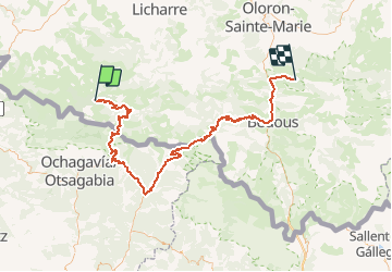
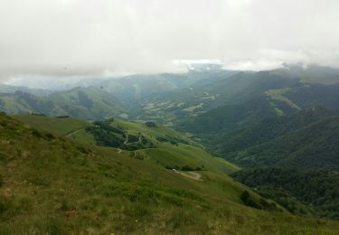
Tocht Mountainbike van 120 km beschikbaar op Nieuw-Aquitanië, Pyrénées-Atlantiques, Larrau. Deze tocht wordt voorgesteld door tracegps.
Beschrijving
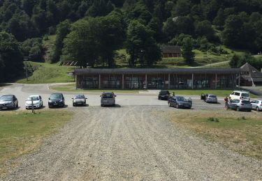
Etape 2/8 de la traversée des Pyrénées en cyclotourisme. Passage du port de Larrau (hors catégorie) et du col de la Pierre saint Martin. Arrivée après les premières pentes du col de Marie Blanque.
Plaatsbepaling
Land:
France
Regio :
Nieuw-Aquitanië
Departement/Provincie :
Pyrénées-Atlantiques
Gemeente :
Larrau
Locatie:
Unknown
Vertrek:(Dec)
Vertrek:(UTM)
658886 ; 4766802 (30T) N.
Opmerkingen
Wandeltochten in de omgeving
![Tocht Stappen Larrau - IRATY le pic des escaliers sans monter au pic 408M+ 2948308 - Photo](https://media.geolcdn.com/t/375/260/1725c3fb-51a3-4e7e-9d48-19cb60baeea0.jpg&format=jpg&maxdim=2)
![Stappen Stappen](https://static1.geolcdn.com/sitytour/trail-icons/101.png)
IRATY le pic des escaliers sans monter au pic 408M+ 2948308
Stappen
Moeilijk
Larrau,
Nieuw-Aquitanië,
Pyrénées-Atlantiques,
France
![](/images/other/stat-length.png)
7,9 km | 13,4 km-effort
3h 2min
![](https://static1.geolcdn.com/siteimages/upload/files/16400158638029165_repeat_loop_refresh_sync_direction_icon.png)
Ja
![Tocht Stappen Larrau - Iraty cabane ZINGOLATZE - Photo](https://media.geolcdn.com/t/375/260/44ee5c4f-fb20-4eee-9c16-d8a5e8350ada.jpg&format=jpg&maxdim=2)
![Stappen Stappen](https://static1.geolcdn.com/sitytour/trail-icons/101.png)
Iraty cabane ZINGOLATZE
Stappen
Heel gemakkelijk
Larrau,
Nieuw-Aquitanië,
Pyrénées-Atlantiques,
France
![](/images/other/stat-length.png)
6,8 km | 9,7 km-effort
3h 29min
![](https://static1.geolcdn.com/siteimages/upload/files/16400158638029165_repeat_loop_refresh_sync_direction_icon.png)
Ja
![Tocht Stappen Larrau - GR 10 T - Photo](https://media.geolcdn.com/t/375/260/5faacc01-4cf0-48af-992e-bb3842b7dc29.jpg&format=jpg&maxdim=2)
![Stappen Stappen](https://static1.geolcdn.com/sitytour/trail-icons/101.png)
GR 10 T
Stappen
Medium
Larrau,
Nieuw-Aquitanië,
Pyrénées-Atlantiques,
France
![](/images/other/stat-length.png)
5,3 km | 7 km-effort
1h 40min
![](https://static1.geolcdn.com/siteimages/upload/files/16400158638029165_repeat_loop_refresh_sync_direction_icon.png)
Neen
![Tocht Stappen Larrau - le Pic des Escalier - Photo](https://media.geolcdn.com/t/375/260/25a58932-02ea-4249-a083-fd59fc4e847e.jpg&format=jpg&maxdim=2)
![Stappen Stappen](https://static1.geolcdn.com/sitytour/trail-icons/101.png)
le Pic des Escalier
Stappen
Medium
Larrau,
Nieuw-Aquitanië,
Pyrénées-Atlantiques,
France
![](/images/other/stat-length.png)
10,4 km | 16,7 km-effort
3h 8min
![](https://static1.geolcdn.com/siteimages/upload/files/16400158638029165_repeat_loop_refresh_sync_direction_icon.png)
Ja
![Tocht Stappen Lecumberry - Okabe magique - Photo](https://media.geolcdn.com/t/375/260/072c8693-4101-429d-bd0b-7f3d41337b96.jpg&format=jpg&maxdim=2)
![Stappen Stappen](https://static1.geolcdn.com/sitytour/trail-icons/101.png)
Okabe magique
Stappen
Moeilijk
Lecumberry,
Nieuw-Aquitanië,
Pyrénées-Atlantiques,
France
![](/images/other/stat-length.png)
15,2 km | 25 km-effort
5h 31min
![](https://static1.geolcdn.com/siteimages/upload/files/16400158638029165_repeat_loop_refresh_sync_direction_icon.png)
Ja
![Tocht Stappen Larrau - Iraty « escaliers » - Photo](https://media.geolcdn.com/t/375/260/42225316-23e6-495d-8c25-50310cc3c362.jpg&format=jpg&maxdim=2)
![Stappen Stappen](https://static1.geolcdn.com/sitytour/trail-icons/101.png)
Iraty « escaliers »
Stappen
Gemakkelijk
Larrau,
Nieuw-Aquitanië,
Pyrénées-Atlantiques,
France
![](/images/other/stat-length.png)
19,1 km | 28 km-effort
6h 32min
![](https://static1.geolcdn.com/siteimages/upload/files/16400158638029165_repeat_loop_refresh_sync_direction_icon.png)
Neen
![Tocht Stappen Lecumberry - IRATI : GOROSTIBIZKARRA 1340m - Photo](https://media.geolcdn.com/t/375/260/a59d3f76-fd9f-4aca-903e-cf76eaa1cfd9.jpg&format=jpg&maxdim=2)
![Stappen Stappen](https://static1.geolcdn.com/sitytour/trail-icons/101.png)
IRATI : GOROSTIBIZKARRA 1340m
Stappen
Gemakkelijk
Lecumberry,
Nieuw-Aquitanië,
Pyrénées-Atlantiques,
France
![](/images/other/stat-length.png)
9,1 km | 13,9 km-effort
2h 41min
![](https://static1.geolcdn.com/siteimages/upload/files/16400158638029165_repeat_loop_refresh_sync_direction_icon.png)
Ja
![Tocht Stappen Larrau - IRATY Chapelle Notre Dame des Neiges et Casas de Irati - Photo](https://media.geolcdn.com/t/375/260/4820dd3f-a315-4e52-ac6d-42397795308f.jpg&format=jpg&maxdim=2)
![Stappen Stappen](https://static1.geolcdn.com/sitytour/trail-icons/101.png)
IRATY Chapelle Notre Dame des Neiges et Casas de Irati
Stappen
Gemakkelijk
Larrau,
Nieuw-Aquitanië,
Pyrénées-Atlantiques,
France
![](/images/other/stat-length.png)
22 km | 33 km-effort
6h 22min
![](https://static1.geolcdn.com/siteimages/upload/files/16400158638029165_repeat_loop_refresh_sync_direction_icon.png)
Ja
![Tocht Stappen Lecumberry - IRATY PETRILARRE-HEGIXURIA en boucle - Photo](https://media.geolcdn.com/t/375/260/858f8db3-ac8d-4103-89b2-b5fb262d83c8.jpg&format=jpg&maxdim=2)
![Stappen Stappen](https://static1.geolcdn.com/sitytour/trail-icons/101.png)
IRATY PETRILARRE-HEGIXURIA en boucle
Stappen
Medium
Lecumberry,
Nieuw-Aquitanië,
Pyrénées-Atlantiques,
France
![](/images/other/stat-length.png)
13,6 km | 22 km-effort
4h 29min
![](https://static1.geolcdn.com/siteimages/upload/files/16400158638029165_repeat_loop_refresh_sync_direction_icon.png)
Ja