![](/images/other/stat-length.png)
![Tocht Lopen Labergement-Sainte-Marie - Tour du lac de Remoray - Photo](https://media.geolcdn.com/t/1900/400/ext.pjpeg?maxdim=2&url=https%3A%2F%2Fservices.sitytrail.com%2FGeolivesWS%2FDownloadMedia.ashx%3FTrailID%3D105599%26Media%3D9366_4.jpg)
Tour du lac de Remoray
tracegps
Gebruiker
![Lengte](/images/other/stat-length.png)
Lengte
17,5 km
![Max. hoogte](https://static1.geolcdn.com/siteimages/upload/files/1508320355ic_sort_altitude_max_24dp.png)
Max. hoogte
971 m
![Positief hoogteverschil](https://static1.geolcdn.com/siteimages/upload/files/1508320355ic_sort_den_pos_24dp.png)
Positief hoogteverschil
369 m
![Km-Effort](/images/other/stat-length.png)
Km-Effort
22 km
![Min. hoogte](https://static1.geolcdn.com/siteimages/upload/files/1508320355ic_sort_altitude_min_24dp.png)
Min. hoogte
847 m
![Negatief hoogteverschil](https://static1.geolcdn.com/siteimages/upload/files/1508320355ic_sort_den_neg_24dp.png)
Negatief hoogteverschil
369 m
![Boucle](https://static1.geolcdn.com/siteimages/upload/files/16400158638029165_repeat_loop_refresh_sync_direction_icon.png)
Boucle
Ja
Datum van aanmaak :
2014-12-10 00:00:00.0
Laatste wijziging :
2014-12-10 00:00:00.0
![Lopen](https://static1.geolcdn.com/sitytour/trail-icons/103.png)
3h00
Moeilijkheid : Medium
![Scan deze QR-code om de tocht te openen in de SityTrail-applicatie](https://capi.geolives.com/qq0zvz2zws4bq2lad0pu/sitytour/trails/105599/qr.png?size=200)
Gratisgps-wandelapplicatie
Over ons
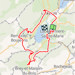
Tocht Lopen van 17,5 km beschikbaar op Bourgondië-Franche-Comté, Doubs, Labergement-Sainte-Marie. Deze tocht wordt voorgesteld door tracegps.
Beschrijving
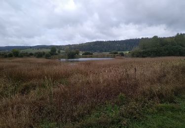
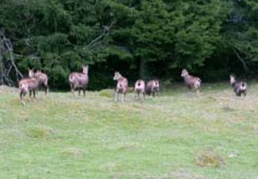
Le lac de Remoray est une réserve naturelle. Ce parcours permet de contempler le lac sous toutes ses coutures. Départ devant le Camping du lac de Labergement Sainte Marie.
Plaatsbepaling
Land:
France
Regio :
Bourgondië-Franche-Comté
Departement/Provincie :
Doubs
Gemeente :
Labergement-Sainte-Marie
Locatie:
Unknown
Vertrek:(Dec)
Vertrek:(UTM)
291956 ; 5183360 (32T) N.
Opmerkingen
Wandeltochten in de omgeving
![Tocht Stappen Remoray-Boujeons - Remoray-Boujeons - Le Belvédère des deux Lacs - Photo](https://media.geolcdn.com/t/375/260/2919c784-c06a-4f62-b624-02a232a2dc80.jpg&format=jpg&maxdim=2)
![Stappen Stappen](https://static1.geolcdn.com/sitytour/trail-icons/101.png)
Remoray-Boujeons - Le Belvédère des deux Lacs
Stappen
Moeilijk
(1)
Remoray-Boujeons,
Bourgondië-Franche-Comté,
Doubs,
France
![](/images/other/stat-length.png)
10,4 km | 13,8 km-effort
2h 58min
![](https://static1.geolcdn.com/siteimages/upload/files/16400158638029165_repeat_loop_refresh_sync_direction_icon.png)
Ja
![Tocht Stappen Remoray-Boujeons - Le Belvédère des 2 lacs - Doubs - Photo](https://media.geolcdn.com/t/375/260/ext.jpg?maxdim=2&url=https%3A%2F%2Fservices.sitytrail.com%2FGeolivesWS%2FDownloadMedia.ashx%3FTrailID%3D108936%26Media%3D2627_1.jpg)
![Stappen Stappen](https://static1.geolcdn.com/sitytour/trail-icons/101.png)
Le Belvédère des 2 lacs - Doubs
Stappen
Moeilijk
(1)
Remoray-Boujeons,
Bourgondië-Franche-Comté,
Doubs,
France
![](/images/other/stat-length.png)
13,7 km | 19 km-effort
4h 0min
![](https://static1.geolcdn.com/siteimages/upload/files/16400158638029165_repeat_loop_refresh_sync_direction_icon.png)
Ja
![Tocht Stappen Saint-Antoine - Boucle du fort St Antoine - Photo](https://media.geolcdn.com/t/375/260/39387965-6cd2-4b9c-a9a7-b089cab08bc2.jpg&format=jpg&maxdim=2)
![Stappen Stappen](https://static1.geolcdn.com/sitytour/trail-icons/101.png)
Boucle du fort St Antoine
Stappen
Medium
Saint-Antoine,
Bourgondië-Franche-Comté,
Doubs,
France
![](/images/other/stat-length.png)
4,8 km | 6,2 km-effort
1h 25min
![](https://static1.geolcdn.com/siteimages/upload/files/16400158638029165_repeat_loop_refresh_sync_direction_icon.png)
Ja
![Tocht Stappen Rochejean - Mont d'or - Photo](https://media.geolcdn.com/t/375/260/22137291-8125-4d4b-9cc5-d81179db76e3.jpg&format=jpg&maxdim=2)
![Stappen Stappen](https://static1.geolcdn.com/sitytour/trail-icons/101.png)
Mont d'or
Stappen
Gemakkelijk
Rochejean,
Bourgondië-Franche-Comté,
Doubs,
France
![](/images/other/stat-length.png)
11,9 km | 17,5 km-effort
4h 53min
![](https://static1.geolcdn.com/siteimages/upload/files/16400158638029165_repeat_loop_refresh_sync_direction_icon.png)
Ja
![Tocht Te voet Malbuisson - Sentier du Tour du Lac - Photo](https://media.geolcdn.com/t/375/260/ec9f6be9-4d56-4db2-b65f-5890444a2963.jpeg&format=jpg&maxdim=2)
![Te voet Te voet](https://static1.geolcdn.com/sitytour/trail-icons/100.png)
Sentier du Tour du Lac
Te voet
Gemakkelijk
Malbuisson,
Bourgondië-Franche-Comté,
Doubs,
France
![](/images/other/stat-length.png)
16 km | 19,9 km-effort
4h 30min
![](https://static1.geolcdn.com/siteimages/upload/files/16400158638029165_repeat_loop_refresh_sync_direction_icon.png)
Neen
![Tocht Noords wandelen Malbuisson - Fort St Antoine - Photo](https://media.geolcdn.com/t/375/260/fe4e7a22-394a-4da9-be49-1254fdb85bde.jpg&format=jpg&maxdim=2)
![Noords wandelen Noords wandelen](https://static1.geolcdn.com/sitytour/trail-icons/102.png)
Fort St Antoine
Noords wandelen
Gemakkelijk
Malbuisson,
Bourgondië-Franche-Comté,
Doubs,
France
![](/images/other/stat-length.png)
5,8 km | 7,3 km-effort
2h 21min
![](https://static1.geolcdn.com/siteimages/upload/files/16400158638029165_repeat_loop_refresh_sync_direction_icon.png)
Ja
![Tocht Stappen Labergement-Sainte-Marie - Lac de Remoray - Photo](https://media.geolcdn.com/t/375/260/ee62ae3a-7d82-4bd9-a18a-0063a4ffda31.jpg&format=jpg&maxdim=2)
![Stappen Stappen](https://static1.geolcdn.com/sitytour/trail-icons/101.png)
Lac de Remoray
Stappen
Gemakkelijk
Labergement-Sainte-Marie,
Bourgondië-Franche-Comté,
Doubs,
France
![](/images/other/stat-length.png)
14,5 km | 18,4 km-effort
3h 25min
![](https://static1.geolcdn.com/siteimages/upload/files/16400158638029165_repeat_loop_refresh_sync_direction_icon.png)
Neen
![Tocht Stappen Remoray-Boujeons - REMORAY - au-dessus du village - Photo](https://media.geolcdn.com/t/375/260/ext.jpg?maxdim=2&url=https%3A%2F%2Fstatic1.geolcdn.com%2Fsiteimages%2Fupload%2Ffiles%2F1553511878bg_sport_marche.png)
![Stappen Stappen](https://static1.geolcdn.com/sitytour/trail-icons/101.png)
REMORAY - au-dessus du village
Stappen
Medium
(1)
Remoray-Boujeons,
Bourgondië-Franche-Comté,
Doubs,
France
![](/images/other/stat-length.png)
8,6 km | 11,7 km-effort
2h 28min
![](https://static1.geolcdn.com/siteimages/upload/files/16400158638029165_repeat_loop_refresh_sync_direction_icon.png)
Ja
![Tocht Mountainbike Labergement-Sainte-Marie - Mont d'Or par les gorges du Fourperet - Franche-Comté, France - Photo](https://media.geolcdn.com/t/375/260/ext.jpg?maxdim=2&url=https%3A%2F%2Fservices.sitytrail.com%2FGeolivesWS%2FDownloadMedia.ashx%3FTrailID%3D105601%26Media%3D9367_4.jpg)
![Mountainbike Mountainbike](https://static1.geolcdn.com/sitytour/trail-icons/202.png)
Mont d'Or par les gorges du Fourperet - Franche-Comté, France
Mountainbike
Moeilijk
Labergement-Sainte-Marie,
Bourgondië-Franche-Comté,
Doubs,
France
![](/images/other/stat-length.png)
23 km | 33 km-effort
4h 0min
![](https://static1.geolcdn.com/siteimages/upload/files/16400158638029165_repeat_loop_refresh_sync_direction_icon.png)
Ja