![](/images/other/stat-length.png)
![Tocht Stappen Saint-Laurent-Blangy - Saint Laurent Blangy - Marchiennes en 3 jours - Photo](https://media.geolcdn.com/t/1900/400/ext.pjpeg?maxdim=2&url=https%3A%2F%2Fservices.sitytrail.com%2FGeolivesWS%2FDownloadMedia.ashx%3FTrailID%3D105458%26Media%3D9194_4.jpg)
Saint Laurent Blangy - Marchiennes en 3 jours
tracegps
Gebruiker
![Lengte](/images/other/stat-length.png)
Lengte
66 km
![Max. hoogte](https://static1.geolcdn.com/siteimages/upload/files/1508320355ic_sort_altitude_max_24dp.png)
Max. hoogte
114 m
![Positief hoogteverschil](https://static1.geolcdn.com/siteimages/upload/files/1508320355ic_sort_den_pos_24dp.png)
Positief hoogteverschil
458 m
![Km-Effort](/images/other/stat-length.png)
Km-Effort
72 km
![Min. hoogte](https://static1.geolcdn.com/siteimages/upload/files/1508320355ic_sort_altitude_min_24dp.png)
Min. hoogte
15 m
![Negatief hoogteverschil](https://static1.geolcdn.com/siteimages/upload/files/1508320355ic_sort_den_neg_24dp.png)
Negatief hoogteverschil
488 m
![Boucle](https://static1.geolcdn.com/siteimages/upload/files/16400158638029165_repeat_loop_refresh_sync_direction_icon.png)
Boucle
Neen
Datum van aanmaak :
2014-12-10 00:00:00.0
Laatste wijziging :
2014-12-10 00:00:00.0
![Stappen](https://static1.geolcdn.com/sitytour/trail-icons/101.png)
17h00
Moeilijkheid : Moeilijk
![Scan deze QR-code om de tocht te openen in de SityTrail-applicatie](https://capi.geolives.com/qq0zvz2zws4bq2lad0pu/sitytour/trails/105458/qr.png?size=200)
Gratisgps-wandelapplicatie
Over ons
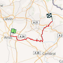
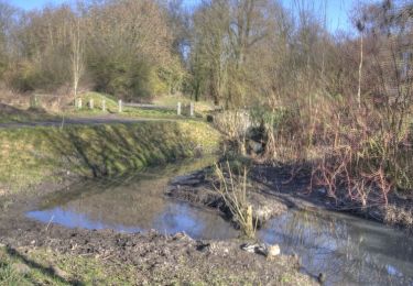
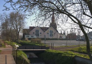
Tocht Stappen van 66 km beschikbaar op Hauts-de-France, Pas-de-Calais, Saint-Laurent-Blangy. Deze tocht wordt voorgesteld door tracegps.
Beschrijving
67km En autonomie complète. Temps mitigé. Jour 1 St laurent Blangy Boiry Notre Dame Jour 2: Boiry -Aubigny au Bac Jours 3: Aubigny Marchiennes. Toutes les informations sur www.nord-gr-randotrek.fr
Plaatsbepaling
Land:
France
Regio :
Hauts-de-France
Departement/Provincie :
Pas-de-Calais
Gemeente :
Saint-Laurent-Blangy
Locatie:
Unknown
Vertrek:(Dec)
Vertrek:(UTM)
485886 ; 5571876 (31U) N.
Opmerkingen
Wandeltochten in de omgeving
![Tocht Stappen Sainte-Catherine - Jardins et monuments - Arras - Photo](https://media.geolcdn.com/t/375/260/ext.jpg?maxdim=2&url=https%3A%2F%2Fservices.sitytrail.com%2FGeolivesWS%2FDownloadMedia.ashx%3FTrailID%3D110053%26Media%3D5162_6.jpg)
![Stappen Stappen](https://static1.geolcdn.com/sitytour/trail-icons/101.png)
Jardins et monuments - Arras
Stappen
Medium
(3)
Sainte-Catherine,
Hauts-de-France,
Pas-de-Calais,
France
![](/images/other/stat-length.png)
9,6 km | 10,6 km-effort
2h 40min
![](https://static1.geolcdn.com/siteimages/upload/files/16400158638029165_repeat_loop_refresh_sync_direction_icon.png)
Ja
![Tocht Stappen Athies - Le chemin du Maresquay - Athies - Photo](https://media.geolcdn.com/t/375/260/ext.jpg?maxdim=2&url=https%3A%2F%2Fservices.sitytrail.com%2FGeolivesWS%2FDownloadMedia.ashx%3FTrailID%3D110048%26Media%3D5157_6.jpg)
![Stappen Stappen](https://static1.geolcdn.com/sitytour/trail-icons/101.png)
Le chemin du Maresquay - Athies
Stappen
Moeilijk
(1)
Athies,
Hauts-de-France,
Pas-de-Calais,
France
![](/images/other/stat-length.png)
12,9 km | 14,3 km-effort
3h 15min
![](https://static1.geolcdn.com/siteimages/upload/files/16400158638029165_repeat_loop_refresh_sync_direction_icon.png)
Ja
![Tocht Stappen Arras - Arras Citadelles Grands Prés 16,5 km - Photo](https://media.geolcdn.com/t/375/260/c9502adb-d79d-4714-8dca-e315baf425eb.jpg&format=jpg&maxdim=2)
![Stappen Stappen](https://static1.geolcdn.com/sitytour/trail-icons/101.png)
Arras Citadelles Grands Prés 16,5 km
Stappen
Moeilijk
Arras,
Hauts-de-France,
Pas-de-Calais,
France
![](/images/other/stat-length.png)
16,4 km | 18,2 km-effort
4h 8min
![](https://static1.geolcdn.com/siteimages/upload/files/16400158638029165_repeat_loop_refresh_sync_direction_icon.png)
Ja
![Tocht Te voet Achicourt - la vallée du crinchon - Photo](https://media.geolcdn.com/t/375/260/ext.jpg?maxdim=2&url=https%3A%2F%2Fstatic1.geolcdn.com%2Fsiteimages%2Fupload%2Ffiles%2F1545311037marcheuse_200dpi.jpg)
![Te voet Te voet](https://static1.geolcdn.com/sitytour/trail-icons/100.png)
la vallée du crinchon
Te voet
Gemakkelijk
(1)
Achicourt,
Hauts-de-France,
Pas-de-Calais,
France
![](/images/other/stat-length.png)
10,7 km | 11,8 km-effort
2h 10min
![](https://static1.geolcdn.com/siteimages/upload/files/16400158638029165_repeat_loop_refresh_sync_direction_icon.png)
Ja
![Tocht Stappen Arras - Beffroi à citadelle d'Arras - Photo](https://media.geolcdn.com/t/375/260/ext.jpg?maxdim=2&url=https%3A%2F%2Fservices.sitytrail.com%2FGeolivesWS%2FDownloadMedia.ashx%3FTrailID%3D945061%26Media%3D20180417064753.jpg)
![Stappen Stappen](https://static1.geolcdn.com/sitytour/trail-icons/101.png)
Beffroi à citadelle d'Arras
Stappen
Heel gemakkelijk
Arras,
Hauts-de-France,
Pas-de-Calais,
France
![](/images/other/stat-length.png)
7,6 km | 8,5 km-effort
1h 31min
![](https://static1.geolcdn.com/siteimages/upload/files/16400158638029165_repeat_loop_refresh_sync_direction_icon.png)
Ja
![Tocht Stappen Arras - La Route du Louvre «La Canadienne» - Arras - Photo](https://media.geolcdn.com/t/375/260/ext.jpg?maxdim=2&url=https%3A%2F%2Fservices.sitytrail.com%2FGeolivesWS%2FDownloadMedia.ashx%3FTrailID%3D317920%26Media%3D17338_6.jpg)
![Stappen Stappen](https://static1.geolcdn.com/sitytour/trail-icons/101.png)
La Route du Louvre «La Canadienne» - Arras
Stappen
Medium
Arras,
Hauts-de-France,
Pas-de-Calais,
France
![](/images/other/stat-length.png)
24 km | 27 km-effort
5h 30min
![](https://static1.geolcdn.com/siteimages/upload/files/16400158638029165_repeat_loop_refresh_sync_direction_icon.png)
Neen
![Tocht Stappen Achicourt - Achicourt - Fossés de la Citadelle - Agny - Photo](https://media.geolcdn.com/t/375/260/ext.jpg?maxdim=2&url=https%3A%2F%2Fservices.sitytrail.com%2FGeolivesWS%2FDownloadMedia.ashx%3FTrailID%3D118888%26Media%3D13112_6.jpg)
![Stappen Stappen](https://static1.geolcdn.com/sitytour/trail-icons/101.png)
Achicourt - Fossés de la Citadelle - Agny
Stappen
Medium
Achicourt,
Hauts-de-France,
Pas-de-Calais,
France
![](/images/other/stat-length.png)
10,7 km | 11,7 km-effort
2h 0min
![](https://static1.geolcdn.com/siteimages/upload/files/16400158638029165_repeat_loop_refresh_sync_direction_icon.png)
Ja
![Tocht Stappen Achicourt - Achicourt - Polygone - Wailly - Agny - Photo](https://media.geolcdn.com/t/375/260/ext.jpg?maxdim=2&url=https%3A%2F%2Fservices.sitytrail.com%2FGeolivesWS%2FDownloadMedia.ashx%3FTrailID%3D118887%26Media%3D13111_6.jpg)
![Stappen Stappen](https://static1.geolcdn.com/sitytour/trail-icons/101.png)
Achicourt - Polygone - Wailly - Agny
Stappen
Medium
Achicourt,
Hauts-de-France,
Pas-de-Calais,
France
![](/images/other/stat-length.png)
11,1 km | 12,1 km-effort
2h 0min
![](https://static1.geolcdn.com/siteimages/upload/files/16400158638029165_repeat_loop_refresh_sync_direction_icon.png)
Ja
![Tocht Stappen Fampoux - Des bords de la Scarpe - Fampoux - Photo](https://media.geolcdn.com/t/375/260/ext.jpg?maxdim=2&url=https%3A%2F%2Fservices.sitytrail.com%2FGeolivesWS%2FDownloadMedia.ashx%3FTrailID%3D110055%26Media%3D5164_5.jpg)
![Stappen Stappen](https://static1.geolcdn.com/sitytour/trail-icons/101.png)
Des bords de la Scarpe - Fampoux
Stappen
Medium
Fampoux,
Hauts-de-France,
Pas-de-Calais,
France
![](/images/other/stat-length.png)
9,6 km | 10,5 km-effort
2h 25min
![](https://static1.geolcdn.com/siteimages/upload/files/16400158638029165_repeat_loop_refresh_sync_direction_icon.png)
Ja