![](/images/other/stat-length.png)
![Tocht Stappen Navour-sur-Grosne - Boucle N°3 autour de Clermain - Photo](https://media.geolcdn.com/t/1900/400/ext.pjpeg?maxdim=2&url=https%3A%2F%2Fstatic1.geolcdn.com%2Fsiteimages%2Fupload%2Ffiles%2F1553511878bg_sport_marche.png)
Boucle N°3 autour de Clermain
tracegps
Gebruiker
![Lengte](/images/other/stat-length.png)
Lengte
18,7 km
![Max. hoogte](https://static1.geolcdn.com/siteimages/upload/files/1508320355ic_sort_altitude_max_24dp.png)
Max. hoogte
527 m
![Positief hoogteverschil](https://static1.geolcdn.com/siteimages/upload/files/1508320355ic_sort_den_pos_24dp.png)
Positief hoogteverschil
676 m
![Km-Effort](/images/other/stat-length.png)
Km-Effort
28 km
![Min. hoogte](https://static1.geolcdn.com/siteimages/upload/files/1508320355ic_sort_altitude_min_24dp.png)
Min. hoogte
268 m
![Negatief hoogteverschil](https://static1.geolcdn.com/siteimages/upload/files/1508320355ic_sort_den_neg_24dp.png)
Negatief hoogteverschil
677 m
![Boucle](https://static1.geolcdn.com/siteimages/upload/files/16400158638029165_repeat_loop_refresh_sync_direction_icon.png)
Boucle
Ja
Datum van aanmaak :
2014-12-10 00:00:00.0
Laatste wijziging :
2014-12-10 00:00:00.0
![Stappen](https://static1.geolcdn.com/sitytour/trail-icons/101.png)
5h00
Moeilijkheid : Medium
![Scan deze QR-code om de tocht te openen in de SityTrail-applicatie](https://capi.geolives.com/qq0zvz2zws4bq2lad0pu/sitytour/trails/105421/qr.png?size=200)
Gratisgps-wandelapplicatie
Over ons
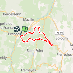
Tocht Stappen van 18,7 km beschikbaar op Bourgondië-Franche-Comté, Saône-et-Loire, Navour-sur-Grosne. Deze tocht wordt voorgesteld door tracegps.
Beschrijving
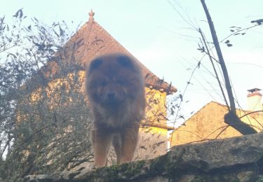
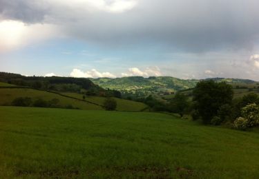
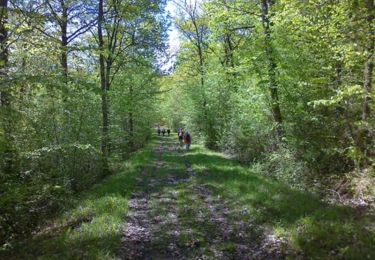
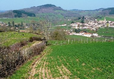
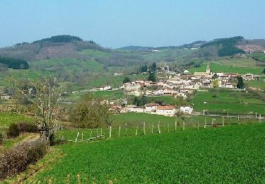
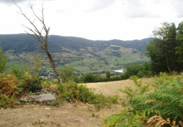
Rando sympathique qui vous fera découvrir les paysages du Haut Clunysois. Passage au Col des Enceins. Possibilité de restauration à Bourgvilain : "Chez la Zette". Accueil pique-nique.
Plaatsbepaling
Land:
France
Regio :
Bourgondië-Franche-Comté
Departement/Provincie :
Saône-et-Loire
Gemeente :
Navour-sur-Grosne
Locatie:
Unknown
Vertrek:(Dec)
Vertrek:(UTM)
621812 ; 5135871 (31T) N.
Opmerkingen
Wandeltochten in de omgeving
![Tocht Stappen Navour-sur-Grosne - Brandon 8,5 km - Photo](https://media.geolcdn.com/t/375/260/5600efb6-5b5a-44a5-94aa-e68fd686e94d.jpg&format=jpg&maxdim=2)
![Stappen Stappen](https://static1.geolcdn.com/sitytour/trail-icons/101.png)
Brandon 8,5 km
Stappen
Medium
Navour-sur-Grosne,
Bourgondië-Franche-Comté,
Saône-et-Loire,
France
![](/images/other/stat-length.png)
8,5 km | 12,4 km-effort
2h 55min
![](https://static1.geolcdn.com/siteimages/upload/files/16400158638029165_repeat_loop_refresh_sync_direction_icon.png)
Ja
![Tocht Stappen Bergesserin - bergesserin - Photo](https://media.geolcdn.com/t/375/260/cacfcb1a-8ee9-4a70-8030-785c61a4d0df.jpg&format=jpg&maxdim=2)
![Stappen Stappen](https://static1.geolcdn.com/sitytour/trail-icons/101.png)
bergesserin
Stappen
Medium
Bergesserin,
Bourgondië-Franche-Comté,
Saône-et-Loire,
France
![](/images/other/stat-length.png)
5,6 km | 7,7 km-effort
2h 11min
![](https://static1.geolcdn.com/siteimages/upload/files/16400158638029165_repeat_loop_refresh_sync_direction_icon.png)
Ja
![Tocht Stappen Sainte-Cécile - Le haut clunisois - Photo](https://media.geolcdn.com/t/375/260/559790a2-338b-4285-914c-ef934d60643e.jpg&format=jpg&maxdim=2)
![Stappen Stappen](https://static1.geolcdn.com/sitytour/trail-icons/101.png)
Le haut clunisois
Stappen
Medium
Sainte-Cécile,
Bourgondië-Franche-Comté,
Saône-et-Loire,
France
![](/images/other/stat-length.png)
14,9 km | 19,6 km-effort
4h 0min
![](https://static1.geolcdn.com/siteimages/upload/files/16400158638029165_repeat_loop_refresh_sync_direction_icon.png)
Ja
![Tocht Stappen Sainte-Cécile - bourgvilain - Photo](https://media.geolcdn.com/t/375/260/62ff2ee8-d2f2-4379-b3b5-421bf7ccfb2e.jpg&format=jpg&maxdim=2)
![Stappen Stappen](https://static1.geolcdn.com/sitytour/trail-icons/101.png)
bourgvilain
Stappen
Moeilijk
Sainte-Cécile,
Bourgondië-Franche-Comté,
Saône-et-Loire,
France
![](/images/other/stat-length.png)
6,4 km | 9,4 km-effort
2h 15min
![](https://static1.geolcdn.com/siteimages/upload/files/16400158638029165_repeat_loop_refresh_sync_direction_icon.png)
Neen
![Tocht Stappen Trambly - Trambly - Saint Leger sous la Bussière - Photo](https://media.geolcdn.com/t/375/260/ext.jpg?maxdim=2&url=https%3A%2F%2Fservices.sitytrail.com%2FGeolivesWS%2FDownloadMedia.ashx%3FTrailID%3D971497%26Media%3D20180521155547.jpg)
![Stappen Stappen](https://static1.geolcdn.com/sitytour/trail-icons/101.png)
Trambly - Saint Leger sous la Bussière
Stappen
Heel gemakkelijk
Trambly,
Bourgondië-Franche-Comté,
Saône-et-Loire,
France
![](/images/other/stat-length.png)
12,8 km | 18,5 km-effort
3h 54min
![](https://static1.geolcdn.com/siteimages/upload/files/16400158638029165_repeat_loop_refresh_sync_direction_icon.png)
Ja
![Tocht Stappen Curtil-sous-Buffières - Rando du 1er Mai - Curtil sous Buffières - Photo](https://media.geolcdn.com/t/375/260/ext.jpg?maxdim=2&url=https%3A%2F%2Fservices.sitytrail.com%2FGeolivesWS%2FDownloadMedia.ashx%3FTrailID%3D129799%26Media%3D13349_5.jpg)
![Stappen Stappen](https://static1.geolcdn.com/sitytour/trail-icons/101.png)
Rando du 1er Mai - Curtil sous Buffières
Stappen
Moeilijk
Curtil-sous-Buffières,
Bourgondië-Franche-Comté,
Saône-et-Loire,
France
![](/images/other/stat-length.png)
25 km | 33 km-effort
5h 30min
![](https://static1.geolcdn.com/siteimages/upload/files/16400158638029165_repeat_loop_refresh_sync_direction_icon.png)
Ja
![Tocht Mountainbike Trambly - Les Serpentines (2012-VTT-25km) - Trambly - Photo](https://media.geolcdn.com/t/375/260/ext.jpg?maxdim=2&url=https%3A%2F%2Fservices.sitytrail.com%2FGeolivesWS%2FDownloadMedia.ashx%3FTrailID%3D129628%26Media%3D13145_6.jpg)
![Mountainbike Mountainbike](https://static1.geolcdn.com/sitytour/trail-icons/202.png)
Les Serpentines (2012-VTT-25km) - Trambly
Mountainbike
Moeilijk
Trambly,
Bourgondië-Franche-Comté,
Saône-et-Loire,
France
![](/images/other/stat-length.png)
25 km | 36 km-effort
2h 30min
![](https://static1.geolcdn.com/siteimages/upload/files/16400158638029165_repeat_loop_refresh_sync_direction_icon.png)
Ja
![Tocht Mountainbike Trambly - Les Serpentines (2012-VTT-35km) - Trambly - Photo](https://media.geolcdn.com/t/375/260/ext.jpg?maxdim=2&url=https%3A%2F%2Fservices.sitytrail.com%2FGeolivesWS%2FDownloadMedia.ashx%3FTrailID%3D129627%26Media%3D13144_6.jpg)
![Mountainbike Mountainbike](https://static1.geolcdn.com/sitytour/trail-icons/202.png)
Les Serpentines (2012-VTT-35km) - Trambly
Mountainbike
Zeer moeilijk
Trambly,
Bourgondië-Franche-Comté,
Saône-et-Loire,
France
![](/images/other/stat-length.png)
36 km | 52 km-effort
3h 0min
![](https://static1.geolcdn.com/siteimages/upload/files/16400158638029165_repeat_loop_refresh_sync_direction_icon.png)
Ja
![Tocht Stappen Navour-sur-Grosne - Les Echeliers - Brandon - Photo](https://media.geolcdn.com/t/375/260/ext.jpg?maxdim=2&url=https%3A%2F%2Fservices.sitytrail.com%2FGeolivesWS%2FDownloadMedia.ashx%3FTrailID%3D111773%26Media%3D8271_3.jpg)
![Stappen Stappen](https://static1.geolcdn.com/sitytour/trail-icons/101.png)
Les Echeliers - Brandon
Stappen
Medium
Navour-sur-Grosne,
Bourgondië-Franche-Comté,
Saône-et-Loire,
France
![](/images/other/stat-length.png)
9,6 km | 14,2 km-effort
2h 45min
![](https://static1.geolcdn.com/siteimages/upload/files/16400158638029165_repeat_loop_refresh_sync_direction_icon.png)
Ja