![](/images/other/stat-length.png)
![Tocht Mountainbike Cloyes-les-Trois-Rivières - Haute vallée du Loir en VTT - Photo](https://media.geolcdn.com/t/1900/400/ext.pjpeg?maxdim=2&url=https%3A%2F%2Fstatic1.geolcdn.com%2Fsiteimages%2Fupload%2Ffiles%2F1524743154velo.jpg)
Haute vallée du Loir en VTT
tracegps
Gebruiker
![Lengte](/images/other/stat-length.png)
Lengte
82 km
![Max. hoogte](https://static1.geolcdn.com/siteimages/upload/files/1508320355ic_sort_altitude_max_24dp.png)
Max. hoogte
156 m
![Positief hoogteverschil](https://static1.geolcdn.com/siteimages/upload/files/1508320355ic_sort_den_pos_24dp.png)
Positief hoogteverschil
953 m
![Km-Effort](/images/other/stat-length.png)
Km-Effort
94 km
![Min. hoogte](https://static1.geolcdn.com/siteimages/upload/files/1508320355ic_sort_altitude_min_24dp.png)
Min. hoogte
95 m
![Negatief hoogteverschil](https://static1.geolcdn.com/siteimages/upload/files/1508320355ic_sort_den_neg_24dp.png)
Negatief hoogteverschil
953 m
![Boucle](https://static1.geolcdn.com/siteimages/upload/files/16400158638029165_repeat_loop_refresh_sync_direction_icon.png)
Boucle
Ja
Datum van aanmaak :
2014-12-10 00:00:00.0
Laatste wijziging :
2014-12-10 00:00:00.0
![Mountainbike](https://static1.geolcdn.com/sitytour/trail-icons/202.png)
4h10
Moeilijkheid : Moeilijk
![Scan deze QR-code om de tocht te openen in de SityTrail-applicatie](https://capi.geolives.com/qq0zvz2zws4bq2lad0pu/sitytour/trails/105411/qr.png?size=200)
Gratisgps-wandelapplicatie
Over ons
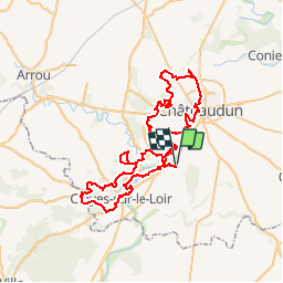
Tocht Mountainbike van 82 km beschikbaar op Centre-Val de Loire, Eure-et-Loir, Cloyes-les-Trois-Rivières. Deze tocht wordt voorgesteld door tracegps.
Beschrijving
Un peu le même circuit que mon autre parcours (Grand Tour d'Autheuil) mais avec une boucle en plus sur la Chapelle du Noyer. Il faut juste prévoir un peu de temps pour effectuer ce parcours...
Plaatsbepaling
Land:
France
Regio :
Centre-Val de Loire
Departement/Provincie :
Eure-et-Loir
Gemeente :
Cloyes-les-Trois-Rivières
Locatie:
Autheuil
Vertrek:(Dec)
Vertrek:(UTM)
373370 ; 5320450 (31U) N.
Opmerkingen
Wandeltochten in de omgeving
![Tocht Stappen Cloyes-les-Trois-Rivières - Moulin rouge - Photo](https://media.geolcdn.com/t/375/260/95b81e81-3e31-474b-a3d6-0d08e49cbede.jpg&format=jpg&maxdim=2)
![Stappen Stappen](https://static1.geolcdn.com/sitytour/trail-icons/101.png)
Moulin rouge
Stappen
Medium
Cloyes-les-Trois-Rivières,
Centre-Val de Loire,
Eure-et-Loir,
France
![](/images/other/stat-length.png)
6,3 km | 7 km-effort
1h 54min
![](https://static1.geolcdn.com/siteimages/upload/files/16400158638029165_repeat_loop_refresh_sync_direction_icon.png)
Ja
![Tocht Stappen Cloyes-les-Trois-Rivières - St-Hilaire-sur-Yerre - Photo](https://media.geolcdn.com/t/375/260/ext.jpg?maxdim=2&url=https%3A%2F%2Fstatic1.geolcdn.com%2Fsiteimages%2Fupload%2Ffiles%2F1553511878bg_sport_marche.png)
![Stappen Stappen](https://static1.geolcdn.com/sitytour/trail-icons/101.png)
St-Hilaire-sur-Yerre
Stappen
Medium
Cloyes-les-Trois-Rivières,
Centre-Val de Loire,
Eure-et-Loir,
France
![](/images/other/stat-length.png)
18,1 km | 21 km-effort
4h 30min
![](https://static1.geolcdn.com/siteimages/upload/files/16400158638029165_repeat_loop_refresh_sync_direction_icon.png)
Ja
![Tocht Te voet Cloyes-les-Trois-Rivières - Douy PC27sept2020 - Photo](https://media.geolcdn.com/t/375/260/ext.jpg?maxdim=2&url=https%3A%2F%2Fstatic1.geolcdn.com%2Fsiteimages%2Fupload%2Ffiles%2F1545311037marcheuse_200dpi.jpg)
![Te voet Te voet](https://static1.geolcdn.com/sitytour/trail-icons/100.png)
Douy PC27sept2020
Te voet
Medium
Cloyes-les-Trois-Rivières,
Centre-Val de Loire,
Eure-et-Loir,
France
![](/images/other/stat-length.png)
11,3 km | 13 km-effort
Onbekend
![](https://static1.geolcdn.com/siteimages/upload/files/16400158638029165_repeat_loop_refresh_sync_direction_icon.png)
Ja
![Tocht Noords wandelen Châteaudun - Marche_Chateaudun_20140326 - Photo](https://media.geolcdn.com/t/375/260/ext.jpg?maxdim=2&url=https%3A%2F%2Fstatic1.geolcdn.com%2Fsiteimages%2Fupload%2Ffiles%2F1545311037marcheuse_200dpi.jpg)
![Noords wandelen Noords wandelen](https://static1.geolcdn.com/sitytour/trail-icons/102.png)
Marche_Chateaudun_20140326
Noords wandelen
Moeilijk
Châteaudun,
Centre-Val de Loire,
Eure-et-Loir,
France
![](/images/other/stat-length.png)
21 km | 24 km-effort
3h 42min
![](https://static1.geolcdn.com/siteimages/upload/files/16400158638029165_repeat_loop_refresh_sync_direction_icon.png)
Ja
![Tocht Mountainbike Cloyes-les-Trois-Rivières - Rando Cloyes 2009 - Photo](https://media.geolcdn.com/t/375/260/ext.jpg?maxdim=2&url=https%3A%2F%2Fstatic1.geolcdn.com%2Fsiteimages%2Fupload%2Ffiles%2F1524743154velo.jpg)
![Mountainbike Mountainbike](https://static1.geolcdn.com/sitytour/trail-icons/202.png)
Rando Cloyes 2009
Mountainbike
Moeilijk
Cloyes-les-Trois-Rivières,
Centre-Val de Loire,
Eure-et-Loir,
France
![](/images/other/stat-length.png)
46 km | 54 km-effort
2h 45min
![](https://static1.geolcdn.com/siteimages/upload/files/16400158638029165_repeat_loop_refresh_sync_direction_icon.png)
Ja
![Tocht Mountainbike Cloyes-les-Trois-Rivières - Vers Saint Denis les ponts - Photo](https://media.geolcdn.com/t/375/260/ext.jpg?maxdim=2&url=https%3A%2F%2Fstatic1.geolcdn.com%2Fsiteimages%2Fupload%2Ffiles%2F1524743154velo.jpg)
![Mountainbike Mountainbike](https://static1.geolcdn.com/sitytour/trail-icons/202.png)
Vers Saint Denis les ponts
Mountainbike
Medium
Cloyes-les-Trois-Rivières,
Centre-Val de Loire,
Eure-et-Loir,
France
![](/images/other/stat-length.png)
33 km | 38 km-effort
2h 0min
![](https://static1.geolcdn.com/siteimages/upload/files/16400158638029165_repeat_loop_refresh_sync_direction_icon.png)
Ja
![Tocht Mountainbike Cloyes-les-Trois-Rivières - Grand Tour d'Autheuil - Photo](https://media.geolcdn.com/t/375/260/ext.jpg?maxdim=2&url=https%3A%2F%2Fstatic1.geolcdn.com%2Fsiteimages%2Fupload%2Ffiles%2F1524743154velo.jpg)
![Mountainbike Mountainbike](https://static1.geolcdn.com/sitytour/trail-icons/202.png)
Grand Tour d'Autheuil
Mountainbike
Moeilijk
Cloyes-les-Trois-Rivières,
Centre-Val de Loire,
Eure-et-Loir,
France
![](/images/other/stat-length.png)
61 km | 69 km-effort
3h 15min
![](https://static1.geolcdn.com/siteimages/upload/files/16400158638029165_repeat_loop_refresh_sync_direction_icon.png)
Ja
![Tocht Stappen Cloyes-les-Trois-Rivières - rando de Montigny - Photo](https://media.geolcdn.com/t/375/260/ext.jpg?maxdim=2&url=https%3A%2F%2Fstatic1.geolcdn.com%2Fsiteimages%2Fupload%2Ffiles%2F1553511878bg_sport_marche.png)
![Stappen Stappen](https://static1.geolcdn.com/sitytour/trail-icons/101.png)
rando de Montigny
Stappen
Medium
Cloyes-les-Trois-Rivières,
Centre-Val de Loire,
Eure-et-Loir,
France
![](/images/other/stat-length.png)
18,1 km | 21 km-effort
4h 0min
![](https://static1.geolcdn.com/siteimages/upload/files/16400158638029165_repeat_loop_refresh_sync_direction_icon.png)
Ja
![Tocht Stappen Cloyes-les-Trois-Rivières - 20231125 ww*wwxx - Photo](https://media.geolcdn.com/t/375/260/ext.jpg?maxdim=2&url=https%3A%2F%2Fstatic1.geolcdn.com%2Fsiteimages%2Fupload%2Ffiles%2F1553511878bg_sport_marche.png)
![Stappen Stappen](https://static1.geolcdn.com/sitytour/trail-icons/101.png)
20231125 ww*wwxx
Stappen
Zeer moeilijk
Cloyes-les-Trois-Rivières,
Centre-Val de Loire,
Eure-et-Loir,
France
![](/images/other/stat-length.png)
26 km | 29 km-effort
6h 10min
![](https://static1.geolcdn.com/siteimages/upload/files/16400158638029165_repeat_loop_refresh_sync_direction_icon.png)
Ja