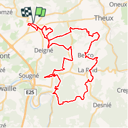
![](/images/other/stat-length.png)
![Tocht Mountainbike Sprimont - Louveigné 43 km - Photo](https://media.geolcdn.com/t/1900/400/ext.pjpeg?maxdim=2&url=https%3A%2F%2Fstatic1.geolcdn.com%2Fsiteimages%2Fupload%2Ffiles%2F1524743154velo.jpg)
Louveigné 43 km
NanardPet
Gebruiker
![Lengte](/images/other/stat-length.png)
![Max. hoogte](https://static1.geolcdn.com/siteimages/upload/files/1508320355ic_sort_altitude_max_24dp.png)
![Positief hoogteverschil](https://static1.geolcdn.com/siteimages/upload/files/1508320355ic_sort_den_pos_24dp.png)
![Km-Effort](/images/other/stat-length.png)
![Min. hoogte](https://static1.geolcdn.com/siteimages/upload/files/1508320355ic_sort_altitude_min_24dp.png)
![Negatief hoogteverschil](https://static1.geolcdn.com/siteimages/upload/files/1508320355ic_sort_den_neg_24dp.png)
![Boucle](https://static1.geolcdn.com/siteimages/upload/files/16400158638029165_repeat_loop_refresh_sync_direction_icon.png)
![Mountainbike](https://static1.geolcdn.com/sitytour/trail-icons/202.png)
3h44
Moeilijkheid : Moeilijk
![Scan deze QR-code om de tocht te openen in de SityTrail-applicatie](https://capi.geolives.com/qq0zvz2zws4bq2lad0pu/sitytour/trails/1053573/qr.png?size=200)
Gratisgps-wandelapplicatie
Over ons
Tocht Mountainbike van 43 km beschikbaar op Wallonië, Luik, Sprimont. Deze tocht wordt voorgesteld door NanardPet.
Beschrijving
Importé de Wikiloc :
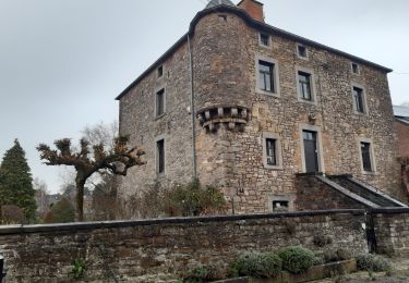
Parcours de 45km et 1100m de D assez physique au départ de Louveigné. Ravitaillement au départ, à La Reid et aléatoirement à Nonceveux. Vélo à Theux et Remouchamps. 1 seul portage de 35m à mi parcours. peu de route et très varié. Région de Theux, La Reid, Nonceveux, Gervova, Ménobu et Deigné. Praticable en toute saison mais attention aux périodes de chasse.
Plaatsbepaling
Opmerkingen
Wandeltochten in de omgeving
![Tocht Stappen Trooz - RB-Lg-03 - Entre Vesdre et Hoëgne - Photo](https://media.geolcdn.com/t/375/260/ext.jpg?maxdim=2&url=https%3A%2F%2Fservices.sitytrail.com%2FGeolivesWS%2FDownloadMedia.ashx%3FTrailID%3D179559%26Media%3Dcef2de81-7d4f-4fcd-9e9d-f315370fe61f.jpg)
![Stappen Stappen](https://static1.geolcdn.com/sitytour/trail-icons/101.png)
Stappen
![](/images/other/stat-length.png)
![](https://static1.geolcdn.com/siteimages/upload/files/16400158638029165_repeat_loop_refresh_sync_direction_icon.png)
![Tocht Stappen Sprimont - Banneux - Rouge Thier - Adzeux - Photo](https://media.geolcdn.com/t/375/260/0f185ab2-d29a-4b49-b676-7a8415068951.jpg&format=jpg&maxdim=2)
![Stappen Stappen](https://static1.geolcdn.com/sitytour/trail-icons/101.png)
Stappen
![](/images/other/stat-length.png)
![](https://static1.geolcdn.com/siteimages/upload/files/16400158638029165_repeat_loop_refresh_sync_direction_icon.png)
![Tocht Stappen Trooz - 2022-02-03_17h57m35_BaladedeFraipont - Photo](https://media.geolcdn.com/t/375/260/a22be754-a7d6-4ac7-b88b-6e30a6735908.jpg&format=jpg&maxdim=2)
![Stappen Stappen](https://static1.geolcdn.com/sitytour/trail-icons/101.png)
Stappen
![](/images/other/stat-length.png)
![](https://static1.geolcdn.com/siteimages/upload/files/16400158638029165_repeat_loop_refresh_sync_direction_icon.png)
![Tocht Stappen Sprimont - banneux . adzeux . grand pierreux . banneux / marche adeps 10 km - Photo](https://media.geolcdn.com/t/375/260/ea0ad600-3155-4a55-9c9f-23c4e38fbcee.jpg&format=jpg&maxdim=2)
![Stappen Stappen](https://static1.geolcdn.com/sitytour/trail-icons/101.png)
Stappen
![](/images/other/stat-length.png)
![](https://static1.geolcdn.com/siteimages/upload/files/16400158638029165_repeat_loop_refresh_sync_direction_icon.png)
![Tocht Stappen Sprimont - les forges . fraipont . andoumont . les forges - Photo](https://media.geolcdn.com/t/375/260/7774fab4-c702-474d-9e3e-f53317a12b64.jpg&format=jpg&maxdim=2)
![Stappen Stappen](https://static1.geolcdn.com/sitytour/trail-icons/101.png)
Stappen
![](/images/other/stat-length.png)
![](https://static1.geolcdn.com/siteimages/upload/files/16400158638029165_repeat_loop_refresh_sync_direction_icon.png)
![Tocht Stappen Olne - Drève pastoureau ch des Meuniers - Photo](https://media.geolcdn.com/t/375/260/04461d40-9e34-4ff2-8b1b-ae0381159e63.jpg&format=jpg&maxdim=2)
![Stappen Stappen](https://static1.geolcdn.com/sitytour/trail-icons/101.png)
Stappen
![](/images/other/stat-length.png)
![](https://static1.geolcdn.com/siteimages/upload/files/16400158638029165_repeat_loop_refresh_sync_direction_icon.png)
![Tocht Stappen Sprimont - rando losange bleu 5 sprimont - Photo](https://media.geolcdn.com/t/375/260/aceb7be4-9650-4462-8975-2891c56fb06a.jpg&format=jpg&maxdim=2)
![Stappen Stappen](https://static1.geolcdn.com/sitytour/trail-icons/101.png)
Stappen
![](/images/other/stat-length.png)
![](https://static1.geolcdn.com/siteimages/upload/files/16400158638029165_repeat_loop_refresh_sync_direction_icon.png)
![Tocht Stappen Theux - entre tancremont et banneux - Photo](https://media.geolcdn.com/t/375/260/fcc24f8e-7347-45dc-9e4e-3d2e2023def3.jpg&format=jpg&maxdim=2)
![Stappen Stappen](https://static1.geolcdn.com/sitytour/trail-icons/101.png)
Stappen
![](/images/other/stat-length.png)
![](https://static1.geolcdn.com/siteimages/upload/files/16400158638029165_repeat_loop_refresh_sync_direction_icon.png)
![Tocht Stappen Sprimont - florzé . redoute . sur la heid . brassine . aywaille . chateau ambleve . totale. rouvreux . florzé - Photo](https://media.geolcdn.com/t/375/260/60c3f9d5-847b-4586-a55c-aafbc9d5270f.jpg&format=jpg&maxdim=2)
![Stappen Stappen](https://static1.geolcdn.com/sitytour/trail-icons/101.png)
Stappen
![](/images/other/stat-length.png)
![](https://static1.geolcdn.com/siteimages/upload/files/16400158638029165_repeat_loop_refresh_sync_direction_icon.png)