![](/images/other/stat-length.png)
![Tocht Stappen Plaisians - De Plaisians à Brantes - Photo](https://media.geolcdn.com/t/1900/400/ext.pjpeg?maxdim=2&url=https%3A%2F%2Fservices.sitytrail.com%2FGeolivesWS%2FDownloadMedia.ashx%3FTrailID%3D105349%26Media%3D9051_1.jpg)
De Plaisians à Brantes
tracegps
Gebruiker
![Lengte](/images/other/stat-length.png)
![Max. hoogte](https://static1.geolcdn.com/siteimages/upload/files/1508320355ic_sort_altitude_max_24dp.png)
![Positief hoogteverschil](https://static1.geolcdn.com/siteimages/upload/files/1508320355ic_sort_den_pos_24dp.png)
![Km-Effort](/images/other/stat-length.png)
![Min. hoogte](https://static1.geolcdn.com/siteimages/upload/files/1508320355ic_sort_altitude_min_24dp.png)
![Negatief hoogteverschil](https://static1.geolcdn.com/siteimages/upload/files/1508320355ic_sort_den_neg_24dp.png)
![Boucle](https://static1.geolcdn.com/siteimages/upload/files/16400158638029165_repeat_loop_refresh_sync_direction_icon.png)
![Stappen](https://static1.geolcdn.com/sitytour/trail-icons/101.png)
4h00
Moeilijkheid : Medium
![Scan deze QR-code om de tocht te openen in de SityTrail-applicatie](https://capi.geolives.com/qq0zvz2zws4bq2lad0pu/sitytour/trails/105349/qr.png?size=200)
Gratisgps-wandelapplicatie
Over ons
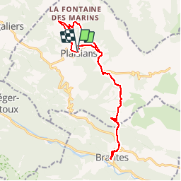
Tocht Stappen van 17,4 km beschikbaar op Auvergne-Rhône-Alpes, Drôme, Plaisians. Deze tocht wordt voorgesteld door tracegps.
Beschrijving
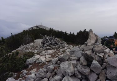
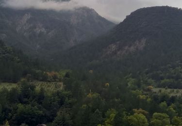
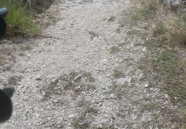
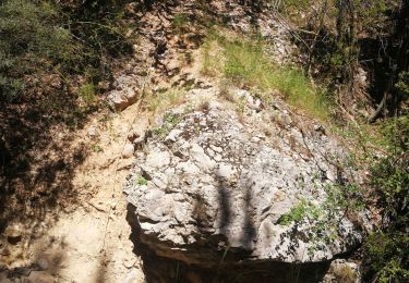
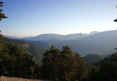
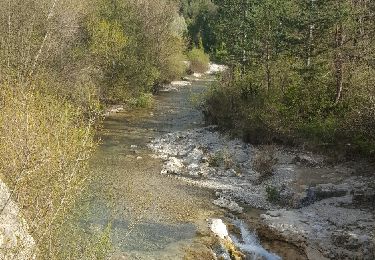
Le départ se fit depuis le village de Plaisians ; nous débutâmes la rando par une montée vers les Arnauds, puis la ferme de Vence, les Girards et le col d’Aiguières. Nous rejoignîmes le GR 9/91 direction plein sud vers Brantes après avoir traversé le ruisseau de Sénaris. Le ciel était parfois menaçant et bien que nous soyons déjà le 1er avril, les giboulées de Mars nous inquiétaient… Pour ne pas laisser le suspense vous nouer les tripes plus longtemps, je dois vous dire qu’elles nous épargnèrent jusqu’au terme de notre randonnée ! Ça, c’est pour les anxieux… C’est à Brantes que les participants décidèrent de déjeuner. Le retour se fit par le même chemin qu’à l’aller ; mais compte tenu des circonstances, il était bien difficile d’imaginer un autre itinéraire. Photos de C. Formet
Plaatsbepaling
Opmerkingen
Wandeltochten in de omgeving
![Tocht Stappen Brantes - Ascencion du Ventoux sur 2 jours j1 - Photo](https://media.geolcdn.com/t/375/260/f9d58ab5-05c4-42e7-b010-c69a5ea3f997.jpg&format=jpg&maxdim=2)
![Stappen Stappen](https://static1.geolcdn.com/sitytour/trail-icons/101.png)
Stappen
![](/images/other/stat-length.png)
![](https://static1.geolcdn.com/siteimages/upload/files/16400158638029165_repeat_loop_refresh_sync_direction_icon.png)
![Tocht Stappen Buis-les-Baronnies - 26 Buis Le Saint-Julien - Photo](https://media.geolcdn.com/t/375/260/6cde8550-608f-4682-99c2-312d252197bd.jpg&format=jpg&maxdim=2)
![Stappen Stappen](https://static1.geolcdn.com/sitytour/trail-icons/101.png)
Stappen
![](/images/other/stat-length.png)
![](https://static1.geolcdn.com/siteimages/upload/files/16400158638029165_repeat_loop_refresh_sync_direction_icon.png)
![Tocht Stappen Beaumont-du-Ventoux - Ventoux-Rochers de Cachillan 12km - Photo](https://media.geolcdn.com/t/375/260/f89fc7c6-5e21-403a-bfed-6357946e3a1d.jpg&format=jpg&maxdim=2)
![Stappen Stappen](https://static1.geolcdn.com/sitytour/trail-icons/101.png)
Stappen
![](/images/other/stat-length.png)
![](https://static1.geolcdn.com/siteimages/upload/files/16400158638029165_repeat_loop_refresh_sync_direction_icon.png)
![Tocht Stappen Saint-Léger-du-Ventoux - Montagne de Bluye - Photo](https://media.geolcdn.com/t/375/260/d3eb69e9-7a46-49b7-8929-c958c5ebc478.jpg&format=jpg&maxdim=2)
![Stappen Stappen](https://static1.geolcdn.com/sitytour/trail-icons/101.png)
Stappen
![](/images/other/stat-length.png)
![](https://static1.geolcdn.com/siteimages/upload/files/16400158638029165_repeat_loop_refresh_sync_direction_icon.png)
![Tocht Stappen Brantes - Brantes - Photo](https://media.geolcdn.com/t/375/260/15141e43-483b-43ca-b9ff-034b5d74afb1.jpg&format=jpg&maxdim=2)
![Stappen Stappen](https://static1.geolcdn.com/sitytour/trail-icons/101.png)
Stappen
![](/images/other/stat-length.png)
![](https://static1.geolcdn.com/siteimages/upload/files/16400158638029165_repeat_loop_refresh_sync_direction_icon.png)
![Tocht Elektrische fiets Buis-les-Baronnies - 26 - Buis les Baronnies/Mollans/Ouveze/Propiac - Photo](https://media.geolcdn.com/t/375/260/9d9860e5-5b56-4dfe-9551-5572b04ff40f.jpg&format=jpg&maxdim=2)
![Elektrische fiets Elektrische fiets](https://static1.geolcdn.com/sitytour/trail-icons/205.png)
Elektrische fiets
![](/images/other/stat-length.png)
![](https://static1.geolcdn.com/siteimages/upload/files/16400158638029165_repeat_loop_refresh_sync_direction_icon.png)
![Tocht Stappen Saint-Léger-du-Ventoux - Boucle au dessus de St Léger du Ventoux - Photo](https://media.geolcdn.com/t/375/260/08d6d962-05ec-47db-a670-7325658b583a.jpg&format=jpg&maxdim=2)
![Stappen Stappen](https://static1.geolcdn.com/sitytour/trail-icons/101.png)
Stappen
![](/images/other/stat-length.png)
![](https://static1.geolcdn.com/siteimages/upload/files/16400158638029165_repeat_loop_refresh_sync_direction_icon.png)
![Tocht Stappen Brantes - Brantes-Ventoux-Frache-Brantes-Bis - Photo](https://media.geolcdn.com/t/375/260/98795d2a-1000-4a35-a743-ee2069a2a291.jpg&format=jpg&maxdim=2)
![Stappen Stappen](https://static1.geolcdn.com/sitytour/trail-icons/101.png)
Stappen
![](/images/other/stat-length.png)
![](https://static1.geolcdn.com/siteimages/upload/files/16400158638029165_repeat_loop_refresh_sync_direction_icon.png)
![Tocht Stappen Saint-Léger-du-Ventoux - Crêtes de la montagne de Bluye - Photo](https://media.geolcdn.com/t/375/260/ext.jpg?maxdim=2&url=https%3A%2F%2Fservices.sitytrail.com%2FGeolivesWS%2FDownloadMedia.ashx%3FTrailID%3D554090%26Media%3Dfix__20160415175803.jpg)
![Stappen Stappen](https://static1.geolcdn.com/sitytour/trail-icons/101.png)
Stappen
![](/images/other/stat-length.png)
![](https://static1.geolcdn.com/siteimages/upload/files/16400158638029165_repeat_loop_refresh_sync_direction_icon.png)