![](/images/other/stat-length.png)
![Tocht Stappen Tilques - Des Cressonnières au Marais - Tilques - Photo](https://media.geolcdn.com/t/1900/400/ext.pjpeg?maxdim=2&url=https%3A%2F%2Fservices.sitytrail.com%2FGeolivesWS%2FDownloadMedia.ashx%3FTrailID%3D105199%26Media%3D8836_2.jpg)
Des Cressonnières au Marais - Tilques
tracegps
Gebruiker
![Lengte](/images/other/stat-length.png)
Lengte
10,7 km
![Max. hoogte](https://static1.geolcdn.com/siteimages/upload/files/1508320355ic_sort_altitude_max_24dp.png)
Max. hoogte
12 m
![Positief hoogteverschil](https://static1.geolcdn.com/siteimages/upload/files/1508320355ic_sort_den_pos_24dp.png)
Positief hoogteverschil
52 m
![Km-Effort](/images/other/stat-length.png)
Km-Effort
11,4 km
![Min. hoogte](https://static1.geolcdn.com/siteimages/upload/files/1508320355ic_sort_altitude_min_24dp.png)
Min. hoogte
-1 m
![Negatief hoogteverschil](https://static1.geolcdn.com/siteimages/upload/files/1508320355ic_sort_den_neg_24dp.png)
Negatief hoogteverschil
52 m
![Boucle](https://static1.geolcdn.com/siteimages/upload/files/16400158638029165_repeat_loop_refresh_sync_direction_icon.png)
Boucle
Ja
Datum van aanmaak :
2014-12-10 00:00:00.0
Laatste wijziging :
2014-12-10 00:00:00.0
![Stappen](https://static1.geolcdn.com/sitytour/trail-icons/101.png)
2h30
Moeilijkheid : Medium
![Scan deze QR-code om de tocht te openen in de SityTrail-applicatie](https://capi.geolives.com/qq0zvz2zws4bq2lad0pu/sitytour/trails/105199/qr.png?size=200)
Gratisgps-wandelapplicatie
Over ons
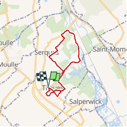
Tocht Stappen van 10,7 km beschikbaar op Hauts-de-France, Pas-de-Calais, Tilques. Deze tocht wordt voorgesteld door tracegps.
Beschrijving
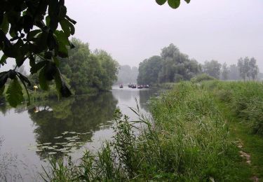
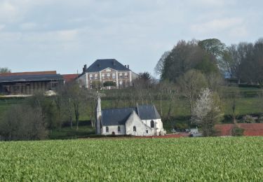
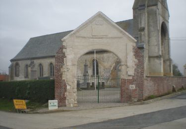
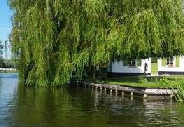
Circuit facile au départ de l'église de Tilques en passant par les cressonnières, le château et ensuite le marais.
Plaatsbepaling
Land:
France
Regio :
Hauts-de-France
Departement/Provincie :
Pas-de-Calais
Gemeente :
Tilques
Locatie:
Unknown
Vertrek:(Dec)
Vertrek:(UTM)
443885 ; 5625432 (31U) N.
Opmerkingen
Wandeltochten in de omgeving
![Tocht Stappen Houlle - Au fil de la Houlle - Photo](https://media.geolcdn.com/t/375/260/ext.jpg?maxdim=2&url=https%3A%2F%2Fservices.sitytrail.com%2FGeolivesWS%2FDownloadMedia.ashx%3FTrailID%3D104031%26Media%3D7008_2.jpg)
![Stappen Stappen](https://static1.geolcdn.com/sitytour/trail-icons/101.png)
Au fil de la Houlle
Stappen
Medium
(1)
Houlle,
Hauts-de-France,
Pas-de-Calais,
France
![](/images/other/stat-length.png)
9,2 km | 9,8 km-effort
2h 30min
![](https://static1.geolcdn.com/siteimages/upload/files/16400158638029165_repeat_loop_refresh_sync_direction_icon.png)
Ja
![Tocht Stappen Serques - marais audomarois - Photo](https://media.geolcdn.com/t/375/260/ext.jpg?maxdim=2&url=https%3A%2F%2Fmedia.geolcdn.com%2Ff%2Fd8070f89-1cd2-42bd-bf65-a9c78abeceb9.jpg)
![Stappen Stappen](https://static1.geolcdn.com/sitytour/trail-icons/101.png)
marais audomarois
Stappen
Gemakkelijk
Serques,
Hauts-de-France,
Pas-de-Calais,
France
![](/images/other/stat-length.png)
8,1 km | 8,5 km-effort
2h 7min
![](https://static1.geolcdn.com/siteimages/upload/files/16400158638029165_repeat_loop_refresh_sync_direction_icon.png)
Ja
![Tocht Stappen Moringhem - Moringhem - Photo](https://media.geolcdn.com/t/375/260/ext.jpg?maxdim=2&url=https%3A%2F%2Fmedia.geolcdn.com%2Ff%2F19ec6069-bead-4ae6-ab83-c67ef270996d.jpeg)
![Stappen Stappen](https://static1.geolcdn.com/sitytour/trail-icons/101.png)
Moringhem
Stappen
Moeilijk
(1)
Moringhem,
Hauts-de-France,
Pas-de-Calais,
France
![](/images/other/stat-length.png)
11 km | 13,5 km-effort
2h 12min
![](https://static1.geolcdn.com/siteimages/upload/files/16400158638029165_repeat_loop_refresh_sync_direction_icon.png)
Ja
![Tocht Stappen Zudausques - Les Cormettes - Zudausques - Photo](https://media.geolcdn.com/t/375/260/ext.jpg?maxdim=2&url=https%3A%2F%2Fservices.sitytrail.com%2FGeolivesWS%2FDownloadMedia.ashx%3FTrailID%3D112080%26Media%3D9729_5.jpg)
![Stappen Stappen](https://static1.geolcdn.com/sitytour/trail-icons/101.png)
Les Cormettes - Zudausques
Stappen
Gemakkelijk
(1)
Zudausques,
Hauts-de-France,
Pas-de-Calais,
France
![](/images/other/stat-length.png)
6,5 km | 7,7 km-effort
1h 40min
![](https://static1.geolcdn.com/siteimages/upload/files/16400158638029165_repeat_loop_refresh_sync_direction_icon.png)
Ja
![Tocht Stappen Moulle - Bayenghem les Eperlecques - Photo](https://media.geolcdn.com/t/375/260/ext.jpg?maxdim=2&url=https%3A%2F%2Fservices.sitytrail.com%2FGeolivesWS%2FDownloadMedia.ashx%3FTrailID%3D104081%26Media%3D7105_3.jpg)
![Stappen Stappen](https://static1.geolcdn.com/sitytour/trail-icons/101.png)
Bayenghem les Eperlecques
Stappen
Medium
Moulle,
Hauts-de-France,
Pas-de-Calais,
France
![](/images/other/stat-length.png)
11,9 km | 12,6 km-effort
2h 30min
![](https://static1.geolcdn.com/siteimages/upload/files/16400158638029165_repeat_loop_refresh_sync_direction_icon.png)
Ja
![Tocht Kanoën - kajakken Tilques - canoé sur le Landsberg à Tilques - Photo](https://media.geolcdn.com/t/375/260/ext.jpg?maxdim=2&url=https%3A%2F%2Fmedia.geolcdn.com%2Ff%2Faa42d85f-60c2-4c16-9158-5e2947ce3bc7.JPG)
![Kanoën - kajakken Kanoën - kajakken](https://static1.geolcdn.com/sitytour/trail-icons/703.png)
canoé sur le Landsberg à Tilques
Kanoën - kajakken
Heel gemakkelijk
Tilques,
Hauts-de-France,
Pas-de-Calais,
France
![](/images/other/stat-length.png)
8 km | 8,3 km-effort
2h 0min
![](https://static1.geolcdn.com/siteimages/upload/files/16400158638029165_repeat_loop_refresh_sync_direction_icon.png)
Ja
![Tocht Mountainbike Sint-Omaars - 2092012 - Photo](https://media.geolcdn.com/t/375/260/ext.jpg?maxdim=2&url=https%3A%2F%2Fservices.sitytrail.com%2FGeolivesWS%2FDownloadMedia.ashx%3FTrailID%3D151052%26Media%3D20120902095703.jpg)
![Mountainbike Mountainbike](https://static1.geolcdn.com/sitytour/trail-icons/202.png)
2092012
Mountainbike
Medium
Sint-Omaars,
Hauts-de-France,
Pas-de-Calais,
France
![](/images/other/stat-length.png)
41 km | 49 km-effort
2h 40min
![](https://static1.geolcdn.com/siteimages/upload/files/16400158638029165_repeat_loop_refresh_sync_direction_icon.png)
Ja
![Tocht Motorboot Salperwijk - Visite du Marais Audomarois - Photo](https://media.geolcdn.com/t/375/260/ext.jpg?maxdim=2&url=https%3A%2F%2Fsecurestorage.geolives.com%2Fsitytour%2Ftrail-bg%2Fdefault.jpg)
![Motorboot Motorboot](https://static1.geolcdn.com/sitytour/trail-icons/701.png)
Visite du Marais Audomarois
Motorboot
Heel gemakkelijk
Salperwijk,
Hauts-de-France,
Pas-de-Calais,
France
![](/images/other/stat-length.png)
3,9 km | 4,1 km-effort
1h 0min
![](https://static1.geolcdn.com/siteimages/upload/files/16400158638029165_repeat_loop_refresh_sync_direction_icon.png)
Ja
![Tocht Stappen Saint-Martin-lez-Tatinghem - wisques - Photo](https://media.geolcdn.com/t/375/260/ext.jpg?maxdim=2&url=https%3A%2F%2Fstatic1.geolcdn.com%2Fsiteimages%2Fupload%2Ffiles%2F1553511878bg_sport_marche.png)
![Stappen Stappen](https://static1.geolcdn.com/sitytour/trail-icons/101.png)
wisques
Stappen
Gemakkelijk
Saint-Martin-lez-Tatinghem,
Hauts-de-France,
Pas-de-Calais,
France
![](/images/other/stat-length.png)
6,3 km | 7,3 km-effort
1h 9min
![](https://static1.geolcdn.com/siteimages/upload/files/16400158638029165_repeat_loop_refresh_sync_direction_icon.png)
Neen