![](/images/other/stat-length.png)
![Tocht Mountainbike Ribeauvillé - Espace VTT FFC Val d'Argent - Circuit n°8 - Le tertre de la Fille Morte - Photo](https://media.geolcdn.com/t/1900/400/ext.pjpeg?maxdim=2&url=https%3A%2F%2Fservices.sitytrail.com%2FGeolivesWS%2FDownloadMedia.ashx%3FTrailID%3D105190%26Media%3D8822_1.jpg)
Espace VTT FFC Val d'Argent - Circuit n°8 - Le tertre de la Fille Morte
tracegps
Gebruiker
![Lengte](/images/other/stat-length.png)
![Max. hoogte](https://static1.geolcdn.com/siteimages/upload/files/1508320355ic_sort_altitude_max_24dp.png)
![Positief hoogteverschil](https://static1.geolcdn.com/siteimages/upload/files/1508320355ic_sort_den_pos_24dp.png)
![Km-Effort](/images/other/stat-length.png)
![Min. hoogte](https://static1.geolcdn.com/siteimages/upload/files/1508320355ic_sort_altitude_min_24dp.png)
![Negatief hoogteverschil](https://static1.geolcdn.com/siteimages/upload/files/1508320355ic_sort_den_neg_24dp.png)
![Boucle](https://static1.geolcdn.com/siteimages/upload/files/16400158638029165_repeat_loop_refresh_sync_direction_icon.png)
![Mountainbike](https://static1.geolcdn.com/sitytour/trail-icons/202.png)
2h00
Moeilijkheid : Moeilijk
![Scan deze QR-code om de tocht te openen in de SityTrail-applicatie](https://capi.geolives.com/qq0zvz2zws4bq2lad0pu/sitytour/trails/105190/qr.png?size=200)
Gratisgps-wandelapplicatie
Over ons
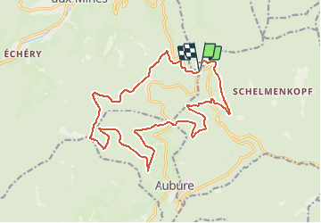
Tocht Mountainbike van 18,5 km beschikbaar op Grand Est, Haut-Rhin, Ribeauvillé. Deze tocht wordt voorgesteld door tracegps.
Beschrijving
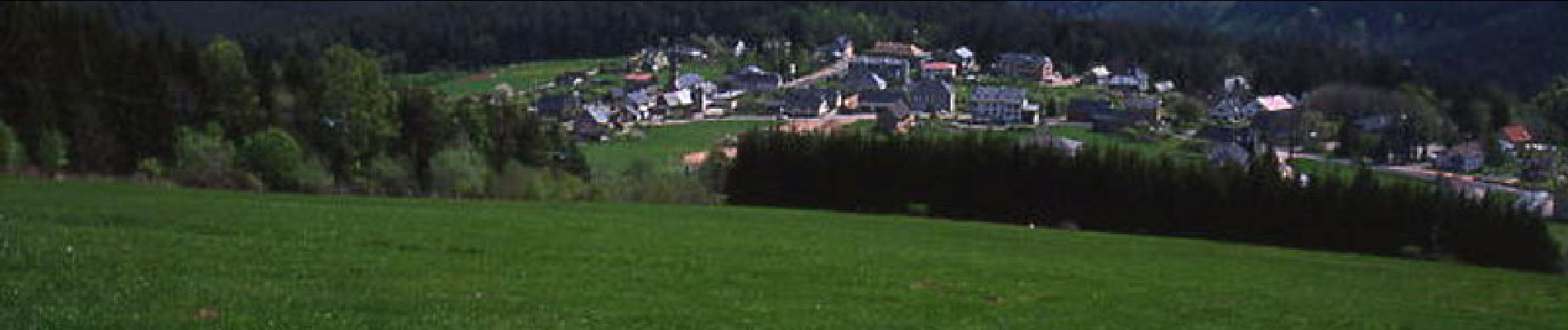
Espace VTT FFC Val d'Argent - Circuit n°8 - Le tertre de la Fille Morte Circuit officiel labellisé par la Fédération Française de Cyclisme. Départ du Col du Haut de Ribeauvillé, parking à 100m (742m). Ce circuit s’adresse particulièrement aux vététistes à la recherche d’un circuit assez court et qui concentre une bonne dose de difficultés physiques et techniques. Les profils du parcours demandent à plusieurs reprises des efforts intenses et soutenus. Ce circuit se déroule en bonne partie sur la charmante commune d’Aubure, la plus haute d’Alsace. Il offre notamment des points de vue vers la plaine d’Alsace.
Plaatsbepaling
Opmerkingen
Wandeltochten in de omgeving
![Tocht Stappen Ribeauvillé - 2023-08-26 Marche Ribeauville Taennchel - Photo](https://media.geolcdn.com/t/375/260/74d8ac69-de70-4d04-a080-288de3ed9a04.jpg&format=jpg&maxdim=2)
![Stappen Stappen](https://static1.geolcdn.com/sitytour/trail-icons/101.png)
Stappen
![](/images/other/stat-length.png)
![](https://static1.geolcdn.com/siteimages/upload/files/16400158638029165_repeat_loop_refresh_sync_direction_icon.png)
![Tocht Paardrijden Aubure - 2019-11-03 WE Aubure Taennchel - Photo](https://media.geolcdn.com/t/375/260/c26e7bc2-614c-4d3d-aa64-9841fd99c8a7.jpg&format=jpg&maxdim=2)
![Paardrijden Paardrijden](https://static1.geolcdn.com/sitytour/trail-icons/301.png)
Paardrijden
![](/images/other/stat-length.png)
![](https://static1.geolcdn.com/siteimages/upload/files/16400158638029165_repeat_loop_refresh_sync_direction_icon.png)
![Tocht Paardrijden Aubure - 2019-11-02 WE Aubure Brezouard - Photo](https://media.geolcdn.com/t/375/260/5d69d4d4-e700-46e3-b109-02de2c2499c8.jpg&format=jpg&maxdim=2)
![Paardrijden Paardrijden](https://static1.geolcdn.com/sitytour/trail-icons/301.png)
Paardrijden
![](/images/other/stat-length.png)
![](https://static1.geolcdn.com/siteimages/upload/files/16400158638029165_repeat_loop_refresh_sync_direction_icon.png)
![Tocht Stappen Sainte-Marie-aux-Mines - la croix de Ribeauvillé - Photo](https://media.geolcdn.com/t/375/260/d5b1ea95-9e8b-4e75-bd59-dd918afbb44b.jpg&format=jpg&maxdim=2)
![Stappen Stappen](https://static1.geolcdn.com/sitytour/trail-icons/101.png)
Stappen
![](/images/other/stat-length.png)
![](https://static1.geolcdn.com/siteimages/upload/files/16400158638029165_repeat_loop_refresh_sync_direction_icon.png)
![Tocht sport Ribeauvillé - Grande verrerie - Rocher des Géants - Photo](https://media.geolcdn.com/t/375/260/30248580-5737-46ba-92f8-71cb1fb9f570.jpg&format=jpg&maxdim=2)
sport
![](/images/other/stat-length.png)
![](https://static1.geolcdn.com/siteimages/upload/files/16400158638029165_repeat_loop_refresh_sync_direction_icon.png)
![Tocht Paardrijden Aubure - Circuit Alsace Vosges Aubure Orbey Et Cigognes - Photo](https://media.geolcdn.com/t/375/260/afad8878-23a0-4d83-b9b1-56130ab42de1.jpg&format=jpg&maxdim=2)
![Paardrijden Paardrijden](https://static1.geolcdn.com/sitytour/trail-icons/301.png)
Paardrijden
![](/images/other/stat-length.png)
![](https://static1.geolcdn.com/siteimages/upload/files/16400158638029165_repeat_loop_refresh_sync_direction_icon.png)
![Tocht Stappen Sainte-Marie-aux-Mines - taenichel - Photo](https://media.geolcdn.com/t/375/260/f89cec21-9478-4217-bf8a-15cadae40096.jpg&format=jpg&maxdim=2)
![Stappen Stappen](https://static1.geolcdn.com/sitytour/trail-icons/101.png)
Stappen
![](/images/other/stat-length.png)
![](https://static1.geolcdn.com/siteimages/upload/files/16400158638029165_repeat_loop_refresh_sync_direction_icon.png)
![Tocht Stappen Aubure - Aubure rocher du tétras - Photo](https://media.geolcdn.com/t/375/260/4c6e9844-5150-479b-b524-d93ad5ebe923.jpg&format=jpg&maxdim=2)
![Stappen Stappen](https://static1.geolcdn.com/sitytour/trail-icons/101.png)
Stappen
![](/images/other/stat-length.png)
![](https://static1.geolcdn.com/siteimages/upload/files/16400158638029165_repeat_loop_refresh_sync_direction_icon.png)
![Tocht Stappen Sainte-Marie-aux-Mines - Col du Haut de Ribeauvillé - Rochers des Géants (Rother n°31) - Photo](https://media.geolcdn.com/t/375/260/cfbc15a6-3f32-42dc-813b-8bce71fe94c9.jpg&format=jpg&maxdim=2)
![Stappen Stappen](https://static1.geolcdn.com/sitytour/trail-icons/101.png)
Stappen
![](/images/other/stat-length.png)
![](https://static1.geolcdn.com/siteimages/upload/files/16400158638029165_repeat_loop_refresh_sync_direction_icon.png)