![](/images/other/stat-length.png)
![Tocht Mountainbike Orry-la-Ville - Orry la Ville - Photo](https://media.geolcdn.com/t/1900/400/ext.pjpeg?maxdim=2&url=https%3A%2F%2Fstatic1.geolcdn.com%2Fsiteimages%2Fupload%2Ffiles%2F1524743154velo.jpg)
Orry la Ville
tracegps
Gebruiker
![Lengte](/images/other/stat-length.png)
Lengte
60 km
![Max. hoogte](https://static1.geolcdn.com/siteimages/upload/files/1508320355ic_sort_altitude_max_24dp.png)
Max. hoogte
216 m
![Positief hoogteverschil](https://static1.geolcdn.com/siteimages/upload/files/1508320355ic_sort_den_pos_24dp.png)
Positief hoogteverschil
716 m
![Km-Effort](/images/other/stat-length.png)
Km-Effort
70 km
![Min. hoogte](https://static1.geolcdn.com/siteimages/upload/files/1508320355ic_sort_altitude_min_24dp.png)
Min. hoogte
46 m
![Negatief hoogteverschil](https://static1.geolcdn.com/siteimages/upload/files/1508320355ic_sort_den_neg_24dp.png)
Negatief hoogteverschil
715 m
![Boucle](https://static1.geolcdn.com/siteimages/upload/files/16400158638029165_repeat_loop_refresh_sync_direction_icon.png)
Boucle
Ja
Datum van aanmaak :
2014-12-10 00:00:00.0
Laatste wijziging :
2014-12-10 00:00:00.0
![Mountainbike](https://static1.geolcdn.com/sitytour/trail-icons/202.png)
4h00
Moeilijkheid : Moeilijk
![Scan deze QR-code om de tocht te openen in de SityTrail-applicatie](https://capi.geolives.com/qq0zvz2zws4bq2lad0pu/sitytour/trails/105078/qr.png?size=200)
Gratisgps-wandelapplicatie
Over ons
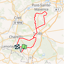
Tocht Mountainbike van 60 km beschikbaar op Hauts-de-France, Oise, Orry-la-Ville. Deze tocht wordt voorgesteld door tracegps.
Beschrijving
Très bonne rando avec l'intérêt du mont Pagnotte retour château de Chantilly et pour finir les étangs de Commelles. D'environ 60km cette rando s'adresse à des vététistes qui aiment l'effort dans la durée.
Plaatsbepaling
Land:
France
Regio :
Hauts-de-France
Departement/Provincie :
Oise
Gemeente :
Orry-la-Ville
Locatie:
Unknown
Vertrek:(Dec)
Vertrek:(UTM)
462830 ; 5443047 (31U) N.
Opmerkingen
Wandeltochten in de omgeving
![Tocht Stappen Orry-la-Ville - Dans la forêt des moines - Orry-la-Ville - Photo](https://media.geolcdn.com/t/375/260/ext.jpg?maxdim=2&url=https%3A%2F%2Fservices.sitytrail.com%2FGeolivesWS%2FDownloadMedia.ashx%3FTrailID%3D112753%26Media%3D11974_6.jpg)
![Stappen Stappen](https://static1.geolcdn.com/sitytour/trail-icons/101.png)
Dans la forêt des moines - Orry-la-Ville
Stappen
Medium
(2)
Orry-la-Ville,
Hauts-de-France,
Oise,
France
![](/images/other/stat-length.png)
9,2 km | 11,2 km-effort
2h 30min
![](https://static1.geolcdn.com/siteimages/upload/files/16400158638029165_repeat_loop_refresh_sync_direction_icon.png)
Ja
![Tocht Stappen Coye-la-Forêt - SM_COYE la FORET_7.9Km - Photo](https://media.geolcdn.com/t/375/260/2c7f88d5-a8c7-4a01-b898-2562006c8bcb.jpg&format=jpg&maxdim=2)
![Stappen Stappen](https://static1.geolcdn.com/sitytour/trail-icons/101.png)
SM_COYE la FORET_7.9Km
Stappen
Medium
(5)
Coye-la-Forêt,
Hauts-de-France,
Oise,
France
![](/images/other/stat-length.png)
7,9 km | 10 km-effort
2h 40min
![](https://static1.geolcdn.com/siteimages/upload/files/16400158638029165_repeat_loop_refresh_sync_direction_icon.png)
Ja
![Tocht Stappen Orry-la-Ville - SM_MONTGRESIN_EST_8.2Km - Photo](https://media.geolcdn.com/t/375/260/311cd4bc-107d-4955-a31f-0f6e6e4d5e34.jpg&format=jpg&maxdim=2)
![Stappen Stappen](https://static1.geolcdn.com/sitytour/trail-icons/101.png)
SM_MONTGRESIN_EST_8.2Km
Stappen
Medium
(6)
Orry-la-Ville,
Hauts-de-France,
Oise,
France
![](/images/other/stat-length.png)
8,2 km | 9,2 km-effort
1h 51min
![](https://static1.geolcdn.com/siteimages/upload/files/16400158638029165_repeat_loop_refresh_sync_direction_icon.png)
Ja
![Tocht Stappen Pontarmé - MR_PONTARME-OUEST_4.9Km - Photo](https://media.geolcdn.com/t/375/260/dbbf6bf6-6d64-4082-9691-d7914590c7ad.jpg&format=jpg&maxdim=2)
![Stappen Stappen](https://static1.geolcdn.com/sitytour/trail-icons/101.png)
MR_PONTARME-OUEST_4.9Km
Stappen
Gemakkelijk
(2)
Pontarmé,
Hauts-de-France,
Oise,
France
![](/images/other/stat-length.png)
4,9 km | 5,5 km-effort
1h 12min
![](https://static1.geolcdn.com/siteimages/upload/files/16400158638029165_repeat_loop_refresh_sync_direction_icon.png)
Ja
![Tocht Stappen Pontarmé - SM_PONTARME_EST(Chateau)_8.6Km - Photo](https://media.geolcdn.com/t/375/260/b81fa35c-5ff8-4c16-a667-6e34ad7ac051.jpg&format=jpg&maxdim=2)
![Stappen Stappen](https://static1.geolcdn.com/sitytour/trail-icons/101.png)
SM_PONTARME_EST(Chateau)_8.6Km
Stappen
Medium
(6)
Pontarmé,
Hauts-de-France,
Oise,
France
![](/images/other/stat-length.png)
8,6 km | 9,7 km-effort
2h 9min
![](https://static1.geolcdn.com/siteimages/upload/files/16400158638029165_repeat_loop_refresh_sync_direction_icon.png)
Ja
![Tocht Stappen Luzarches - Autour d'Orry la Ville - Photo](https://media.geolcdn.com/t/375/260/ext.jpg?maxdim=2&url=https%3A%2F%2Fservices.sitytrail.com%2FGeolivesWS%2FDownloadMedia.ashx%3FTrailID%3D110190%26Media%3D5411_1.jpg)
![Stappen Stappen](https://static1.geolcdn.com/sitytour/trail-icons/101.png)
Autour d'Orry la Ville
Stappen
Medium
(1)
Luzarches,
Île-de-France,
Val-d'Oise,
France
![](/images/other/stat-length.png)
22 km | 26 km-effort
4h 25min
![](https://static1.geolcdn.com/siteimages/upload/files/16400158638029165_repeat_loop_refresh_sync_direction_icon.png)
Ja
![Tocht Stappen Orry-la-Ville - La forêt des étangs de Comelle - Orry la Ville - Photo](https://media.geolcdn.com/t/375/260/ext.jpg?maxdim=2&url=https%3A%2F%2Fservices.sitytrail.com%2FGeolivesWS%2FDownloadMedia.ashx%3FTrailID%3D106559%26Media%3D11129_1.jpg)
![Stappen Stappen](https://static1.geolcdn.com/sitytour/trail-icons/101.png)
La forêt des étangs de Comelle - Orry la Ville
Stappen
Medium
(1)
Orry-la-Ville,
Hauts-de-France,
Oise,
France
![](/images/other/stat-length.png)
11,4 km | 13 km-effort
4h 0min
![](https://static1.geolcdn.com/siteimages/upload/files/16400158638029165_repeat_loop_refresh_sync_direction_icon.png)
Ja
![Tocht Stappen Fosses - Boucle Survilliers - St Witz - Moussy le neuf - Plailly 25 km - Photo](https://media.geolcdn.com/t/375/260/6acc754b-b0c4-4c8e-9dba-f497fb8b1c3a.jpg&format=jpg&maxdim=2)
![Stappen Stappen](https://static1.geolcdn.com/sitytour/trail-icons/101.png)
Boucle Survilliers - St Witz - Moussy le neuf - Plailly 25 km
Stappen
Medium
Fosses,
Île-de-France,
Val-d'Oise,
France
![](/images/other/stat-length.png)
26 km | 30 km-effort
5h 27min
![](https://static1.geolcdn.com/siteimages/upload/files/16400158638029165_repeat_loop_refresh_sync_direction_icon.png)
Ja
![Tocht Stappen Orry-la-Ville - FORET DE COYE BOUCLE 16 KM - Photo](https://media.geolcdn.com/t/375/260/ext.jpg?maxdim=2&url=https%3A%2F%2Fstatic1.geolcdn.com%2Fsiteimages%2Fupload%2Ffiles%2F1553511878bg_sport_marche.png)
![Stappen Stappen](https://static1.geolcdn.com/sitytour/trail-icons/101.png)
FORET DE COYE BOUCLE 16 KM
Stappen
Zeer moeilijk
(1)
Orry-la-Ville,
Hauts-de-France,
Oise,
France
![](/images/other/stat-length.png)
16,3 km | 19,4 km-effort
4h 23min
![](https://static1.geolcdn.com/siteimages/upload/files/16400158638029165_repeat_loop_refresh_sync_direction_icon.png)
Neen