Tocht Mountainbike Mortcerf - Espace VTT FFC - Les Coteaux du Morin et de l'Aubetin - Circuit n° 20 - Grand raid - Mortcerf - Photo

Espace VTT FFC - Les Coteaux du Morin et de l'Aubetin - Circuit n° 20 - Grand raid - Mortcerf

 tracegps
tracegps

Gebruiker

© OpenStreetMap contributors
Lengte
Lengte
106 km
Max. hoogte
Max. hoogte
168 m
Positief hoogteverschil
1232 m
Km-Effort
Km-Effort  
122 km
Min. hoogte
Min. hoogte
52 m
Negatief hoogteverschil
1231 m
Boucle
Boucle
Ja
Datum van aanmaak :
2014-12-10 00:00:00.0
Laatste wijziging :
2014-12-10 00:00:00.0

(0 Bericht)

Mountainbike
Mountainbike
8h00
Moeilijkheid : Zeer moeilijk

Scan deze QR-code om de tocht te openen in de SityTrail-applicatie

Gratisgps-wandelapplicatie

Logo SityTrail SityTrail

IGN / Geografische instituten

SityTrail uit de App Store downloaden SityTrail uit Google Play downloaden

Logo SityTrail SityTrail World

De wereld gaat voor u open

SityTrail uit de App Store downloaden SityTrail uit Google Play downloaden SityTrail op Huawei AppGallery downloaden

Over ons

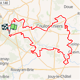
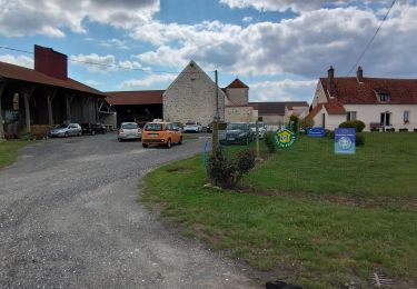
Tocht Mountainbike van 106 km beschikbaar op Île-de-France, Seine-et-Marne, Mortcerf. Deze tocht wordt voorgesteld door tracegps.

Beschrijving

Espace VTT FFC - Les Coteaux du Morin et de l'Aubetin - Circuit n° 20 - Grand raid Départ : Cette boucle peut être empruntée au départ des circuits suivants : n°1 (Amillis) / n°5 (Coulommiers) / n°6 (Dagny) / n°8 (Faremoutiers) / n°10 (Marolles-en-Brie / n°12 (Mortcerf) / n°13 (Pommeuse) / n°16 (Touquin) BON COURAGE !!! Information touristique - Points d’accueils • Office du tourisme : 7 rue du Général de Gaulle - 77120 COULOMMIERS Tél. : 01 64 03 88 09 - mail : off.tourisme@coulommiers.fr • Vélo Nature : 8 avenue de Strasbourg - 77120 COULOMMIERS Tél. : 01 64 20 84 42 - mail : velonature@tele2.fr • Association cycliste partenaire Association Cycliste Pommeuse Boissy (ACPB) Site internet : http://acpommeuseboissy.free.fr

Hoogteprofiel

Foto's

Plaatsbepaling

Land:
France
Regio :
Île-de-France
Departement/Provincie :
Seine-et-Marne
Gemeente :
Mortcerf
Locatie:
Unknown
Vertrek:(Dec)
Vertrek:(UTM)
493243 ; 5403967 (31U) N.

Wandeltochten in de omgeving

Tocht Mountainbike Mortcerf - Espace VTT FFC - Les Coteaux du Morin et de l'Aubetin - Circuit n° 12 - Mortcerf - Photo
Mountainbike
tracegps

Mountainbike

Medium
(1)
Mortcerf, Île-de-France, Seine-et-Marne, France
12 km | 13,8 km-effort
1h 0min
Ja
Tocht Te voet Mortcerf - Boucle autour de Mortcerf - Photo
Te voet
GUIDE
chessyca

Te voet

Heel gemakkelijk
Mortcerf, Île-de-France, Seine-et-Marne, France
22 km | 26 km-effort
5h 53min
Ja
Tocht Stappen Mortcerf - Le tour du Grand Paris via le GR1 - Etape 11 Morcerf - Verneuil l'Etang - Photo
Stappen
GUIDE
chessyca

Stappen

Medium
Mortcerf, Île-de-France, Seine-et-Marne, France
31 km | 34 km-effort
5h 41min
Neen
Tocht Stappen Mortcerf - Boucle 20 km autour de Mortcerf - Photo
Stappen
GUIDE
chessyca

Stappen

Medium
Mortcerf, Île-de-France, Seine-et-Marne, France
21 km | 25 km-effort
5h 5min
Ja
Tocht Stappen Guérard - Guérard  - Photo
Stappen
pikibangi

Stappen

Moeilijk
Guérard, Île-de-France, Seine-et-Marne, France
15,4 km | 18,5 km-effort
4h 3min
Ja
Tocht Stappen Tigeaux - Tigeaux - Photo
Stappen
Tournan

Stappen

Medium
(1)
Tigeaux, Île-de-France, Seine-et-Marne, France
19,1 km | 24 km-effort
5h 24min
Ja
Tocht Stappen Crèvecœur-en-Brie - Crèvecoeur-en-Brie - Photo
Stappen
pikibangi

Stappen

Gemakkelijk
Crèvecœur-en-Brie, Île-de-France, Seine-et-Marne, France
4,4 km | 4,7 km-effort
1h 22min
Ja
Tocht sport Hautefeuille - 2019-08-10_23h17m35_parcours_Hautefeuille - Photo
sport
mouma_77

sport

Heel gemakkelijk
(1)
Hautefeuille, Île-de-France, Seine-et-Marne, France
15,3 km | 17,2 km-effort
Onbekend
Ja
Tocht Stappen Mortcerf - obelisque - Photo
Stappen
jmv77

Stappen

Heel gemakkelijk
Mortcerf, Île-de-France, Seine-et-Marne, France
11,8 km | 12,7 km-effort
2h 44min
Ja


Sluiten
Mijn abonnementen