![](/images/other/stat-length.png)
![Tocht Stappen Yzeron - Yzeron - Les terres de Barmont - Photo](https://media.geolcdn.com/t/1900/400/ext.pjpeg?maxdim=2&url=https%3A%2F%2Fstatic1.geolcdn.com%2Fsiteimages%2Fupload%2Ffiles%2F1553511878bg_sport_marche.png)
Yzeron - Les terres de Barmont
tracegps
Gebruiker
![Lengte](/images/other/stat-length.png)
Lengte
11,3 km
![Max. hoogte](https://static1.geolcdn.com/siteimages/upload/files/1508320355ic_sort_altitude_max_24dp.png)
Max. hoogte
858 m
![Positief hoogteverschil](https://static1.geolcdn.com/siteimages/upload/files/1508320355ic_sort_den_pos_24dp.png)
Positief hoogteverschil
309 m
![Km-Effort](/images/other/stat-length.png)
Km-Effort
15,4 km
![Min. hoogte](https://static1.geolcdn.com/siteimages/upload/files/1508320355ic_sort_altitude_min_24dp.png)
Min. hoogte
664 m
![Negatief hoogteverschil](https://static1.geolcdn.com/siteimages/upload/files/1508320355ic_sort_den_neg_24dp.png)
Negatief hoogteverschil
308 m
![Boucle](https://static1.geolcdn.com/siteimages/upload/files/16400158638029165_repeat_loop_refresh_sync_direction_icon.png)
Boucle
Ja
Datum van aanmaak :
2014-12-10 00:00:00.0
Laatste wijziging :
2014-12-10 00:00:00.0
![Stappen](https://static1.geolcdn.com/sitytour/trail-icons/101.png)
2h45
Moeilijkheid : Moeilijk
![Scan deze QR-code om de tocht te openen in de SityTrail-applicatie](https://capi.geolives.com/qq0zvz2zws4bq2lad0pu/sitytour/trails/104810/qr.png?size=200)
Gratisgps-wandelapplicatie
Over ons
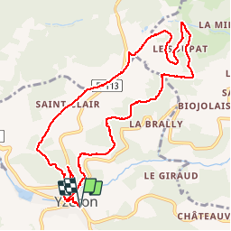
Tocht Stappen van 11,3 km beschikbaar op Auvergne-Rhône-Alpes, Rhône, Yzeron. Deze tocht wordt voorgesteld door tracegps.
Beschrijving
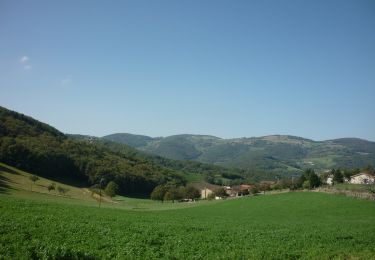
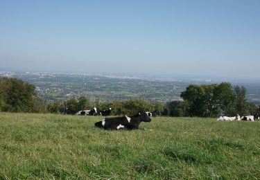
Circuit passant dans les bois et sur les crêts du Lyonnais, belle vue sur les Alpes. 12km. Départ place du village, Yzeron.
Plaatsbepaling
Land:
France
Regio :
Auvergne-Rhône-Alpes
Departement/Provincie :
Rhône
Gemeente :
Yzeron
Locatie:
Unknown
Vertrek:(Dec)
Vertrek:(UTM)
623898 ; 5062744 (31T) N.
Opmerkingen
Wandeltochten in de omgeving
![Tocht Stappen Thurins - tour du bois du baron - Photo](https://media.geolcdn.com/t/375/260/ext.jpg?maxdim=2&url=https%3A%2F%2Fservices.sitytrail.com%2FGeolivesWS%2FDownloadMedia.ashx%3FTrailID%3D548394%26Media%3Dfix__20160403153341.jpg)
![Stappen Stappen](https://static1.geolcdn.com/sitytour/trail-icons/101.png)
tour du bois du baron
Stappen
Gemakkelijk
(3)
Thurins,
Auvergne-Rhône-Alpes,
Rhône,
France
![](/images/other/stat-length.png)
7,4 km | 11,5 km-effort
1h 40min
![](https://static1.geolcdn.com/siteimages/upload/files/16400158638029165_repeat_loop_refresh_sync_direction_icon.png)
Ja
![Tocht Stappen Courzieu - 2023-05-11_18h58m29_Fiche Verte n°5_Courzieu - Photo](https://media.geolcdn.com/t/375/260/ext.jpg?maxdim=2&url=https%3A%2F%2Fstatic1.geolcdn.com%2Fsiteimages%2Fupload%2Ffiles%2F1553511878bg_sport_marche.png)
![Stappen Stappen](https://static1.geolcdn.com/sitytour/trail-icons/101.png)
2023-05-11_18h58m29_Fiche Verte n°5_Courzieu
Stappen
Moeilijk
(1)
Courzieu,
Auvergne-Rhône-Alpes,
Rhône,
France
![](/images/other/stat-length.png)
9 km | 15 km-effort
3h 23min
![](https://static1.geolcdn.com/siteimages/upload/files/16400158638029165_repeat_loop_refresh_sync_direction_icon.png)
Ja
![Tocht Stappen Thurins - thurins la chap. château neuf st Laurent de vaux - Photo](https://media.geolcdn.com/t/375/260/f3d6c053-06d8-4319-9ba3-960eec1a724b.jpg&format=jpg&maxdim=2)
![Stappen Stappen](https://static1.geolcdn.com/sitytour/trail-icons/101.png)
thurins la chap. château neuf st Laurent de vaux
Stappen
Zeer moeilijk
Thurins,
Auvergne-Rhône-Alpes,
Rhône,
France
![](/images/other/stat-length.png)
15,3 km | 24 km-effort
3h 37min
![](https://static1.geolcdn.com/siteimages/upload/files/16400158638029165_repeat_loop_refresh_sync_direction_icon.png)
Ja
![Tocht Te voet Vaugneray - La Tournée des Grands Ducs - Photo](https://media.geolcdn.com/t/375/260/972136c8-825e-4998-bd12-df4d0a9cbb24.jpeg&format=jpg&maxdim=2)
![Te voet Te voet](https://static1.geolcdn.com/sitytour/trail-icons/100.png)
La Tournée des Grands Ducs
Te voet
Moeilijk
Vaugneray,
Auvergne-Rhône-Alpes,
Rhône,
France
![](/images/other/stat-length.png)
26 km | 38 km-effort
8h 42min
![](https://static1.geolcdn.com/siteimages/upload/files/16400158638029165_repeat_loop_refresh_sync_direction_icon.png)
Ja
![Tocht Te voet Vaugneray - La Voie Romaine - Photo](https://media.geolcdn.com/t/375/260/972136c8-825e-4998-bd12-df4d0a9cbb24.jpeg&format=jpg&maxdim=2)
![Te voet Te voet](https://static1.geolcdn.com/sitytour/trail-icons/100.png)
La Voie Romaine
Te voet
Medium
Vaugneray,
Auvergne-Rhône-Alpes,
Rhône,
France
![](/images/other/stat-length.png)
13,7 km | 20 km-effort
4h 36min
![](https://static1.geolcdn.com/siteimages/upload/files/16400158638029165_repeat_loop_refresh_sync_direction_icon.png)
Ja
![Tocht Te voet Vaugneray - Circuit du Capauduc - Photo](https://media.geolcdn.com/t/375/260/2fad17de-e3ff-4154-a54e-2b877983e049.jpeg&format=jpg&maxdim=2)
![Te voet Te voet](https://static1.geolcdn.com/sitytour/trail-icons/100.png)
Circuit du Capauduc
Te voet
Medium
Vaugneray,
Auvergne-Rhône-Alpes,
Rhône,
France
![](/images/other/stat-length.png)
17,5 km | 25 km-effort
5h 45min
![](https://static1.geolcdn.com/siteimages/upload/files/16400158638029165_repeat_loop_refresh_sync_direction_icon.png)
Ja
![Tocht Te voet Saint-Martin-en-Haut - Circuit des Sources du Garon - Photo](https://media.geolcdn.com/t/375/260/fe014065-bc06-4e54-b660-6900e183f331.jpeg&format=jpg&maxdim=2)
![Te voet Te voet](https://static1.geolcdn.com/sitytour/trail-icons/100.png)
Circuit des Sources du Garon
Te voet
Medium
Saint-Martin-en-Haut,
Auvergne-Rhône-Alpes,
Rhône,
France
![](/images/other/stat-length.png)
15,7 km | 22 km-effort
5h 3min
![](https://static1.geolcdn.com/siteimages/upload/files/16400158638029165_repeat_loop_refresh_sync_direction_icon.png)
Ja
![Tocht Te voet Yzeron - La Marmite du Diable - Photo](https://media.geolcdn.com/t/375/260/adaff439-7668-48a6-bae9-58355ae28789.jpeg&format=jpg&maxdim=2)
![Te voet Te voet](https://static1.geolcdn.com/sitytour/trail-icons/100.png)
La Marmite du Diable
Te voet
Medium
Yzeron,
Auvergne-Rhône-Alpes,
Rhône,
France
![](/images/other/stat-length.png)
21 km | 30 km-effort
6h 55min
![](https://static1.geolcdn.com/siteimages/upload/files/16400158638029165_repeat_loop_refresh_sync_direction_icon.png)
Ja
![Tocht Te voet Vaugneray - Le plat de Saint-Romain - Photo](https://media.geolcdn.com/t/375/260/51fb468f-076e-4af0-8a5a-4e4f1e15fee9.jpeg&format=jpg&maxdim=2)
![Te voet Te voet](https://static1.geolcdn.com/sitytour/trail-icons/100.png)
Le plat de Saint-Romain
Te voet
Gemakkelijk
Vaugneray,
Auvergne-Rhône-Alpes,
Rhône,
France
![](/images/other/stat-length.png)
8,1 km | 9,6 km-effort
2h 11min
![](https://static1.geolcdn.com/siteimages/upload/files/16400158638029165_repeat_loop_refresh_sync_direction_icon.png)
Neen
très bien belle vue