![](/images/other/stat-length.png)
![Tocht Stappen Saint-Saturnin - Monne St-Saturnin - Photo](https://media.geolcdn.com/t/1900/400/ext.pjpeg?maxdim=2&url=https%3A%2F%2Fstatic1.geolcdn.com%2Fsiteimages%2Fupload%2Ffiles%2F1553511878bg_sport_marche.png)
Monne St-Saturnin
loursblanc
Gebruiker
![Lengte](/images/other/stat-length.png)
![Max. hoogte](https://static1.geolcdn.com/siteimages/upload/files/1508320355ic_sort_altitude_max_24dp.png)
![Positief hoogteverschil](https://static1.geolcdn.com/siteimages/upload/files/1508320355ic_sort_den_pos_24dp.png)
![Km-Effort](/images/other/stat-length.png)
![Min. hoogte](https://static1.geolcdn.com/siteimages/upload/files/1508320355ic_sort_altitude_min_24dp.png)
![Negatief hoogteverschil](https://static1.geolcdn.com/siteimages/upload/files/1508320355ic_sort_den_neg_24dp.png)
![Boucle](https://static1.geolcdn.com/siteimages/upload/files/16400158638029165_repeat_loop_refresh_sync_direction_icon.png)
![Stappen](https://static1.geolcdn.com/sitytour/trail-icons/101.png)
4h28
Moeilijkheid : Moeilijk
![Scan deze QR-code om de tocht te openen in de SityTrail-applicatie](https://capi.geolives.com/qq0zvz2zws4bq2lad0pu/sitytour/trails/1047538/qr.png?size=200)
Gratisgps-wandelapplicatie
Over ons
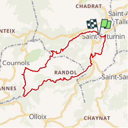
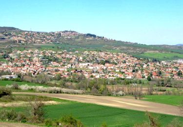
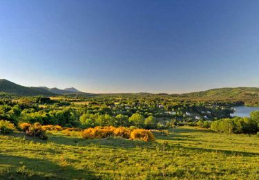
Tocht Stappen van 15,7 km beschikbaar op Auvergne-Rhône-Alpes, Puy-de-Dôme, Saint-Saturnin. Deze tocht wordt voorgesteld door loursblanc.
Beschrijving
Nouveau parcours qui vous feras longer un sentier le long de la Monne sur 5 kms au lieu de 500m.Attention entre le km 8 et 13 je pense que le gps est de rigueur, le sentier monte et descends voir escalade,on s'y perd un peu.Je mets cette portion en difficile.
Bonne ballade
Plaatsbepaling
Opmerkingen
Wandeltochten in de omgeving
![Tocht Te voet Saint-Saturnin - Randol - Photo](https://media.geolcdn.com/t/375/260/9e85dae3-ad96-41f9-a960-52d6d206727c.jpeg&format=jpg&maxdim=2)
![Te voet Te voet](https://static1.geolcdn.com/sitytour/trail-icons/100.png)
Te voet
![](/images/other/stat-length.png)
![](https://static1.geolcdn.com/siteimages/upload/files/16400158638029165_repeat_loop_refresh_sync_direction_icon.png)
![Tocht Te voet Saint-Saturnin - Les Cirques de longevette et des Cotes - Photo](https://media.geolcdn.com/t/375/260/35f5865b-8ac0-4231-943a-09bc6fa13964.jpeg&format=jpg&maxdim=2)
![Te voet Te voet](https://static1.geolcdn.com/sitytour/trail-icons/100.png)
Te voet
![](/images/other/stat-length.png)
![](https://static1.geolcdn.com/siteimages/upload/files/16400158638029165_repeat_loop_refresh_sync_direction_icon.png)
![Tocht Te voet Saint-Amant-Tallende - Le Puy de Peyronere - Photo](https://media.geolcdn.com/t/375/260/a5859447-4468-4d79-8d71-76c1effac2f0.jpeg&format=jpg&maxdim=2)
![Te voet Te voet](https://static1.geolcdn.com/sitytour/trail-icons/100.png)
Te voet
![](/images/other/stat-length.png)
![](https://static1.geolcdn.com/siteimages/upload/files/16400158638029165_repeat_loop_refresh_sync_direction_icon.png)
![Tocht Te voet Saint-Genès-Champanelle - Nadaillat - Photo](https://media.geolcdn.com/t/375/260/f63239da-1e27-43d7-84c3-ba50289c6d9e.jpeg&format=jpg&maxdim=2)
![Te voet Te voet](https://static1.geolcdn.com/sitytour/trail-icons/100.png)
Te voet
![](/images/other/stat-length.png)
![](https://static1.geolcdn.com/siteimages/upload/files/16400158638029165_repeat_loop_refresh_sync_direction_icon.png)
![Tocht Te voet Chanonat - Le Crest - Photo](https://media.geolcdn.com/t/375/260/c9b3d1da-554f-4873-8d44-afc3e6570967.jpeg&format=jpg&maxdim=2)
![Te voet Te voet](https://static1.geolcdn.com/sitytour/trail-icons/100.png)
Te voet
![](/images/other/stat-length.png)
![](https://static1.geolcdn.com/siteimages/upload/files/16400158638029165_repeat_loop_refresh_sync_direction_icon.png)
![Tocht Te voet Chanonat - Le Puy de Jussat - Photo](https://media.geolcdn.com/t/375/260/73982e6a-da33-4176-a420-7d563bd2d917.jpeg&format=jpg&maxdim=2)
![Te voet Te voet](https://static1.geolcdn.com/sitytour/trail-icons/100.png)
Te voet
![](/images/other/stat-length.png)
![](https://static1.geolcdn.com/siteimages/upload/files/16400158638029165_repeat_loop_refresh_sync_direction_icon.png)
![Tocht Stappen Saint-Saturnin - St saturnin - Photo](https://media.geolcdn.com/t/375/260/ext.jpg?maxdim=2&url=https%3A%2F%2Fstatic1.geolcdn.com%2Fsiteimages%2Fupload%2Ffiles%2F1553511878bg_sport_marche.png)
![Stappen Stappen](https://static1.geolcdn.com/sitytour/trail-icons/101.png)
Stappen
![](/images/other/stat-length.png)
![](https://static1.geolcdn.com/siteimages/upload/files/16400158638029165_repeat_loop_refresh_sync_direction_icon.png)
![Tocht Stappen Tallende - Tallende_Vergers - Photo](https://media.geolcdn.com/t/375/260/21ff72c2-26ec-4080-9597-4d3d84e8de42.jpg&format=jpg&maxdim=2)
![Stappen Stappen](https://static1.geolcdn.com/sitytour/trail-icons/101.png)
Stappen
![](/images/other/stat-length.png)
![](https://static1.geolcdn.com/siteimages/upload/files/16400158638029165_repeat_loop_refresh_sync_direction_icon.png)
![Tocht Stappen Chanonat - Chanonat_Chadrat_Montagne_Serre - Photo](https://media.geolcdn.com/t/375/260/a8132fed-526a-41c8-8565-da107e2efd0c.jpg&format=jpg&maxdim=2)
![Stappen Stappen](https://static1.geolcdn.com/sitytour/trail-icons/101.png)
Stappen
![](/images/other/stat-length.png)
![](https://static1.geolcdn.com/siteimages/upload/files/16400158638029165_repeat_loop_refresh_sync_direction_icon.png)