![](/images/other/stat-length.png)
![Tocht Stappen Feuchy - Feuchy Fampoux - Photo](https://media.geolcdn.com/t/1900/400/ext.pjpeg?maxdim=2&url=https%3A%2F%2Fstatic1.geolcdn.com%2Fsiteimages%2Fupload%2Ffiles%2F1553511878bg_sport_marche.png)
Feuchy Fampoux
tracegps
Gebruiker
![Lengte](/images/other/stat-length.png)
Lengte
10,8 km
![Max. hoogte](https://static1.geolcdn.com/siteimages/upload/files/1508320355ic_sort_altitude_max_24dp.png)
Max. hoogte
100 m
![Positief hoogteverschil](https://static1.geolcdn.com/siteimages/upload/files/1508320355ic_sort_den_pos_24dp.png)
Positief hoogteverschil
99 m
![Km-Effort](/images/other/stat-length.png)
Km-Effort
12,1 km
![Min. hoogte](https://static1.geolcdn.com/siteimages/upload/files/1508320355ic_sort_altitude_min_24dp.png)
Min. hoogte
46 m
![Negatief hoogteverschil](https://static1.geolcdn.com/siteimages/upload/files/1508320355ic_sort_den_neg_24dp.png)
Negatief hoogteverschil
100 m
![Boucle](https://static1.geolcdn.com/siteimages/upload/files/16400158638029165_repeat_loop_refresh_sync_direction_icon.png)
Boucle
Ja
Datum van aanmaak :
2014-12-10 00:00:00.0
Laatste wijziging :
2014-12-10 00:00:00.0
![Stappen](https://static1.geolcdn.com/sitytour/trail-icons/101.png)
2h00
Moeilijkheid : Medium
![Scan deze QR-code om de tocht te openen in de SityTrail-applicatie](https://capi.geolives.com/qq0zvz2zws4bq2lad0pu/sitytour/trails/104714/qr.png?size=200)
Gratisgps-wandelapplicatie
Over ons
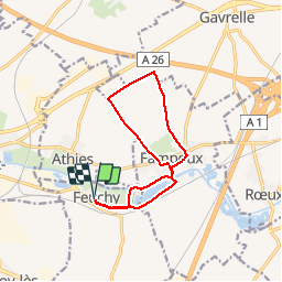
Tocht Stappen van 10,8 km beschikbaar op Hauts-de-France, Pas-de-Calais, Feuchy. Deze tocht wordt voorgesteld door tracegps.
Beschrijving
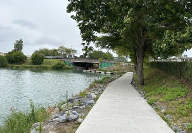
Randonnée au départ de Feuchy qui nous emmène à Fampoux en longeant les marais, puis dans les champs au dessus de Fampoux et nous fait rejoindre le point de départ en longeant la Scarpe et en traversant un marais.
Plaatsbepaling
Land:
France
Regio :
Hauts-de-France
Departement/Provincie :
Pas-de-Calais
Gemeente :
Feuchy
Locatie:
Unknown
Vertrek:(Dec)
Vertrek:(UTM)
488929 ; 5571338 (31U) N.
Opmerkingen
Wandeltochten in de omgeving
![Tocht Stappen Athies - Le chemin du Maresquay - Athies - Photo](https://media.geolcdn.com/t/375/260/ext.jpg?maxdim=2&url=https%3A%2F%2Fservices.sitytrail.com%2FGeolivesWS%2FDownloadMedia.ashx%3FTrailID%3D110048%26Media%3D5157_6.jpg)
![Stappen Stappen](https://static1.geolcdn.com/sitytour/trail-icons/101.png)
Le chemin du Maresquay - Athies
Stappen
Moeilijk
(1)
Athies,
Hauts-de-France,
Pas-de-Calais,
France
![](/images/other/stat-length.png)
12,9 km | 14,3 km-effort
3h 15min
![](https://static1.geolcdn.com/siteimages/upload/files/16400158638029165_repeat_loop_refresh_sync_direction_icon.png)
Ja
![Tocht Stappen Monchy-le-Preux - Le chemin du Caribou - Monchy le Preux - Photo](https://media.geolcdn.com/t/375/260/ext.jpg?maxdim=2&url=https%3A%2F%2Fservices.sitytrail.com%2FGeolivesWS%2FDownloadMedia.ashx%3FTrailID%3D109907%26Media%3D4917_5.jpg)
![Stappen Stappen](https://static1.geolcdn.com/sitytour/trail-icons/101.png)
Le chemin du Caribou - Monchy le Preux
Stappen
Medium
(1)
Monchy-le-Preux,
Hauts-de-France,
Pas-de-Calais,
France
![](/images/other/stat-length.png)
9,2 km | 10,1 km-effort
2h 19min
![](https://static1.geolcdn.com/siteimages/upload/files/16400158638029165_repeat_loop_refresh_sync_direction_icon.png)
Ja
![Tocht Stappen Arras - Arras Citadelles Grands Prés 16,5 km - Photo](https://media.geolcdn.com/t/375/260/c9502adb-d79d-4714-8dca-e315baf425eb.jpg&format=jpg&maxdim=2)
![Stappen Stappen](https://static1.geolcdn.com/sitytour/trail-icons/101.png)
Arras Citadelles Grands Prés 16,5 km
Stappen
Moeilijk
Arras,
Hauts-de-France,
Pas-de-Calais,
France
![](/images/other/stat-length.png)
16,4 km | 18,2 km-effort
4h 8min
![](https://static1.geolcdn.com/siteimages/upload/files/16400158638029165_repeat_loop_refresh_sync_direction_icon.png)
Ja
![Tocht Stappen Arras - Beffroi à citadelle d'Arras - Photo](https://media.geolcdn.com/t/375/260/ext.jpg?maxdim=2&url=https%3A%2F%2Fservices.sitytrail.com%2FGeolivesWS%2FDownloadMedia.ashx%3FTrailID%3D945061%26Media%3D20180417064753.jpg)
![Stappen Stappen](https://static1.geolcdn.com/sitytour/trail-icons/101.png)
Beffroi à citadelle d'Arras
Stappen
Heel gemakkelijk
Arras,
Hauts-de-France,
Pas-de-Calais,
France
![](/images/other/stat-length.png)
7,6 km | 8,5 km-effort
1h 31min
![](https://static1.geolcdn.com/siteimages/upload/files/16400158638029165_repeat_loop_refresh_sync_direction_icon.png)
Ja
![Tocht Stappen Arras - La Route du Louvre «La Canadienne» - Arras - Photo](https://media.geolcdn.com/t/375/260/ext.jpg?maxdim=2&url=https%3A%2F%2Fservices.sitytrail.com%2FGeolivesWS%2FDownloadMedia.ashx%3FTrailID%3D317920%26Media%3D17338_6.jpg)
![Stappen Stappen](https://static1.geolcdn.com/sitytour/trail-icons/101.png)
La Route du Louvre «La Canadienne» - Arras
Stappen
Medium
Arras,
Hauts-de-France,
Pas-de-Calais,
France
![](/images/other/stat-length.png)
24 km | 27 km-effort
5h 30min
![](https://static1.geolcdn.com/siteimages/upload/files/16400158638029165_repeat_loop_refresh_sync_direction_icon.png)
Neen
![Tocht Stappen Rœux - De Roeux à Pelves via Monchy-le-Preux - Photo](https://media.geolcdn.com/t/375/260/ext.jpg?maxdim=2&url=https%3A%2F%2Fservices.sitytrail.com%2FGeolivesWS%2FDownloadMedia.ashx%3FTrailID%3D191391%26Media%3D14962_6.jpg)
![Stappen Stappen](https://static1.geolcdn.com/sitytour/trail-icons/101.png)
De Roeux à Pelves via Monchy-le-Preux
Stappen
Medium
Rœux,
Hauts-de-France,
Pas-de-Calais,
France
![](/images/other/stat-length.png)
9,5 km | 10,6 km-effort
2h 30min
![](https://static1.geolcdn.com/siteimages/upload/files/16400158638029165_repeat_loop_refresh_sync_direction_icon.png)
Ja
![Tocht Stappen Rœux - De Roeux à Plouvain - Photo](https://media.geolcdn.com/t/375/260/ext.jpg?maxdim=2&url=https%3A%2F%2Fservices.sitytrail.com%2FGeolivesWS%2FDownloadMedia.ashx%3FTrailID%3D173057%26Media%3D14581_4.jpg)
![Stappen Stappen](https://static1.geolcdn.com/sitytour/trail-icons/101.png)
De Roeux à Plouvain
Stappen
Gemakkelijk
Rœux,
Hauts-de-France,
Pas-de-Calais,
France
![](/images/other/stat-length.png)
6,3 km | 6,6 km-effort
1h 34min
![](https://static1.geolcdn.com/siteimages/upload/files/16400158638029165_repeat_loop_refresh_sync_direction_icon.png)
Ja
![Tocht Stappen Rœux - Lacs et marais - Roeux - Photo](https://media.geolcdn.com/t/375/260/ext.jpg?maxdim=2&url=https%3A%2F%2Fservices.sitytrail.com%2FGeolivesWS%2FDownloadMedia.ashx%3FTrailID%3D172538%26Media%3D13904_6.jpg)
![Stappen Stappen](https://static1.geolcdn.com/sitytour/trail-icons/101.png)
Lacs et marais - Roeux
Stappen
Zeer moeilijk
Rœux,
Hauts-de-France,
Pas-de-Calais,
France
![](/images/other/stat-length.png)
18,3 km | 19,6 km-effort
4h 30min
![](https://static1.geolcdn.com/siteimages/upload/files/16400158638029165_repeat_loop_refresh_sync_direction_icon.png)
Ja
![Tocht Stappen Fampoux - Des bords de la Scarpe - Fampoux - Photo](https://media.geolcdn.com/t/375/260/ext.jpg?maxdim=2&url=https%3A%2F%2Fservices.sitytrail.com%2FGeolivesWS%2FDownloadMedia.ashx%3FTrailID%3D110055%26Media%3D5164_5.jpg)
![Stappen Stappen](https://static1.geolcdn.com/sitytour/trail-icons/101.png)
Des bords de la Scarpe - Fampoux
Stappen
Medium
Fampoux,
Hauts-de-France,
Pas-de-Calais,
France
![](/images/other/stat-length.png)
9,6 km | 10,5 km-effort
2h 25min
![](https://static1.geolcdn.com/siteimages/upload/files/16400158638029165_repeat_loop_refresh_sync_direction_icon.png)
Ja