![](/images/other/stat-length.png)
![Tocht Stappen Bligny-sur-Ouche - La Vierge Noire - Lusigny sur Ouche - Photo](https://media.geolcdn.com/t/1900/400/ext.pjpeg?maxdim=2&url=https%3A%2F%2Fservices.sitytrail.com%2FGeolivesWS%2FDownloadMedia.ashx%3FTrailID%3D104683%26Media%3D8086_1.jpg)
La Vierge Noire - Lusigny sur Ouche
tracegps
Gebruiker
![Lengte](/images/other/stat-length.png)
![Max. hoogte](https://static1.geolcdn.com/siteimages/upload/files/1508320355ic_sort_altitude_max_24dp.png)
![Positief hoogteverschil](https://static1.geolcdn.com/siteimages/upload/files/1508320355ic_sort_den_pos_24dp.png)
![Km-Effort](/images/other/stat-length.png)
![Min. hoogte](https://static1.geolcdn.com/siteimages/upload/files/1508320355ic_sort_altitude_min_24dp.png)
![Negatief hoogteverschil](https://static1.geolcdn.com/siteimages/upload/files/1508320355ic_sort_den_neg_24dp.png)
![Boucle](https://static1.geolcdn.com/siteimages/upload/files/16400158638029165_repeat_loop_refresh_sync_direction_icon.png)
![Stappen](https://static1.geolcdn.com/sitytour/trail-icons/101.png)
4h00
Moeilijkheid : Medium
![Scan deze QR-code om de tocht te openen in de SityTrail-applicatie](https://capi.geolives.com/qq0zvz2zws4bq2lad0pu/sitytour/trails/104683/qr.png?size=200)
Gratisgps-wandelapplicatie
Over ons
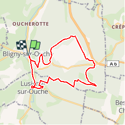
Tocht Stappen van 15,6 km beschikbaar op Bourgondië-Franche-Comté, Côte-d'Or, Bligny-sur-Ouche. Deze tocht wordt voorgesteld door tracegps.
Beschrijving
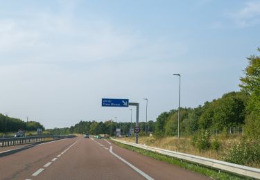
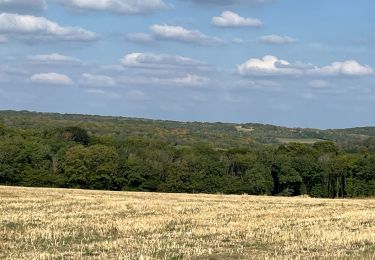
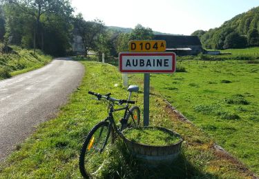
La Vierge Noire Distance 15,6 km, faible dénivelé (330 m), durée 4 heures. La traversée de la ferme "La Ruchotte" n'étant plus permise, nous avons contourné à l'est sur la route de Bessey-en-Chaume ; ce qui rallonge légèrement l'itinéraire officiel. Renseignements à l'Office de Tourisme de Bligny-sur-Ouche. Une randonnée du Club Alpin Français de l'Ouest Dijonnais. « Si tu veux aller un peu plus loin, avec le CAFOD tu feras des randonnées pas comme les autres» ! Avertissement : Les itinéraires mentionnés ici ne sont pas vérifiés (droit de passage, accidents de terrain, etc...). Par conséquent, il convient avant le départ de se renseigner sur la faisabilité du circuit envisagé.
Plaatsbepaling
Opmerkingen
Wandeltochten in de omgeving
![Tocht Te voet Bligny-sur-Ouche - Rail d'Antan 5 km - Photo](https://media.geolcdn.com/t/375/260/637ca046-a32c-4148-a597-8ba378120e94.jpeg&format=jpg&maxdim=2)
![Te voet Te voet](https://static1.geolcdn.com/sitytour/trail-icons/100.png)
Te voet
![](/images/other/stat-length.png)
![](https://static1.geolcdn.com/siteimages/upload/files/16400158638029165_repeat_loop_refresh_sync_direction_icon.png)
![Tocht Te voet Bligny-sur-Ouche - Rail d'Antan 23 km - Photo](https://media.geolcdn.com/t/375/260/ad7c0928-387a-4851-9db7-b39d4b8213ed.jpeg&format=jpg&maxdim=2)
![Te voet Te voet](https://static1.geolcdn.com/sitytour/trail-icons/100.png)
Te voet
![](/images/other/stat-length.png)
![](https://static1.geolcdn.com/siteimages/upload/files/16400158638029165_repeat_loop_refresh_sync_direction_icon.png)
![Tocht Te voet Bligny-sur-Ouche - Rail d'Antan 13 km - Photo](https://media.geolcdn.com/t/375/260/637ca046-a32c-4148-a597-8ba378120e94.jpeg&format=jpg&maxdim=2)
![Te voet Te voet](https://static1.geolcdn.com/sitytour/trail-icons/100.png)
Te voet
![](/images/other/stat-length.png)
![](https://static1.geolcdn.com/siteimages/upload/files/16400158638029165_repeat_loop_refresh_sync_direction_icon.png)
![Tocht Te voet Bligny-sur-Ouche - De la Croix de Mission à la Vierge Noire - Photo](https://media.geolcdn.com/t/375/260/b329de3d-70a8-4983-83fa-da9c75f9d5eb.jpeg&format=jpg&maxdim=2)
![Te voet Te voet](https://static1.geolcdn.com/sitytour/trail-icons/100.png)
Te voet
![](/images/other/stat-length.png)
![](https://static1.geolcdn.com/siteimages/upload/files/16400158638029165_repeat_loop_refresh_sync_direction_icon.png)
![Tocht Te voet Bligny-sur-Ouche - Chemin des Sources de l'Ouche (B) - Photo](https://media.geolcdn.com/t/375/260/637ca046-a32c-4148-a597-8ba378120e94.jpeg&format=jpg&maxdim=2)
![Te voet Te voet](https://static1.geolcdn.com/sitytour/trail-icons/100.png)
Te voet
![](/images/other/stat-length.png)
![](https://static1.geolcdn.com/siteimages/upload/files/16400158638029165_repeat_loop_refresh_sync_direction_icon.png)
![Tocht Te voet Bligny-sur-Ouche - Chemin des Sources de l'Ouche (A) - Photo](https://media.geolcdn.com/t/375/260/637ca046-a32c-4148-a597-8ba378120e94.jpeg&format=jpg&maxdim=2)
![Te voet Te voet](https://static1.geolcdn.com/sitytour/trail-icons/100.png)
Te voet
![](/images/other/stat-length.png)
![](https://static1.geolcdn.com/siteimages/upload/files/16400158638029165_repeat_loop_refresh_sync_direction_icon.png)
![Tocht Te voet Bligny-sur-Ouche - Chemin de la Montagne - Photo](https://media.geolcdn.com/t/375/260/637ca046-a32c-4148-a597-8ba378120e94.jpeg&format=jpg&maxdim=2)
![Te voet Te voet](https://static1.geolcdn.com/sitytour/trail-icons/100.png)
Te voet
![](/images/other/stat-length.png)
![](https://static1.geolcdn.com/siteimages/upload/files/16400158638029165_repeat_loop_refresh_sync_direction_icon.png)
![Tocht Stappen Aubaine - Crepey - Photo](https://media.geolcdn.com/t/375/260/33bc5ff2-3522-4c54-bf0e-867878a671e4.jpg&format=jpg&maxdim=2)
![Stappen Stappen](https://static1.geolcdn.com/sitytour/trail-icons/101.png)
Stappen
![](/images/other/stat-length.png)
![](https://static1.geolcdn.com/siteimages/upload/files/16400158638029165_repeat_loop_refresh_sync_direction_icon.png)
![Tocht Te voet Aubaine - De Combe en Combe - Photo](https://media.geolcdn.com/t/375/260/572ed625-a2ec-4ae3-841c-ffdf7cab621d.jpeg&format=jpg&maxdim=2)
![Te voet Te voet](https://static1.geolcdn.com/sitytour/trail-icons/100.png)
Te voet
![](/images/other/stat-length.png)
![](https://static1.geolcdn.com/siteimages/upload/files/16400158638029165_repeat_loop_refresh_sync_direction_icon.png)
bof...