![](/images/other/stat-length.png)
![Tocht Mountainbike Fougères - Fougères boucle 3 - Photo](https://media.geolcdn.com/t/1900/400/ext.pjpeg?maxdim=2&url=https%3A%2F%2Fservices.sitytrail.com%2FGeolivesWS%2FDownloadMedia.ashx%3FTrailID%3D104640%26Media%3D8023_4.jpg)
Fougères boucle 3
tracegps
Gebruiker
![Lengte](/images/other/stat-length.png)
Lengte
9,2 km
![Max. hoogte](https://static1.geolcdn.com/siteimages/upload/files/1508320355ic_sort_altitude_max_24dp.png)
Max. hoogte
108 m
![Positief hoogteverschil](https://static1.geolcdn.com/siteimages/upload/files/1508320355ic_sort_den_pos_24dp.png)
Positief hoogteverschil
79 m
![Km-Effort](/images/other/stat-length.png)
Km-Effort
10,3 km
![Min. hoogte](https://static1.geolcdn.com/siteimages/upload/files/1508320355ic_sort_altitude_min_24dp.png)
Min. hoogte
72 m
![Negatief hoogteverschil](https://static1.geolcdn.com/siteimages/upload/files/1508320355ic_sort_den_neg_24dp.png)
Negatief hoogteverschil
81 m
![Boucle](https://static1.geolcdn.com/siteimages/upload/files/16400158638029165_repeat_loop_refresh_sync_direction_icon.png)
Boucle
Ja
Datum van aanmaak :
2014-12-10 00:00:00.0
Laatste wijziging :
2014-12-10 00:00:00.0
![Mountainbike](https://static1.geolcdn.com/sitytour/trail-icons/202.png)
25m
Moeilijkheid : Gemakkelijk
![Scan deze QR-code om de tocht te openen in de SityTrail-applicatie](https://capi.geolives.com/qq0zvz2zws4bq2lad0pu/sitytour/trails/104640/qr.png?size=200)
Gratisgps-wandelapplicatie
Over ons
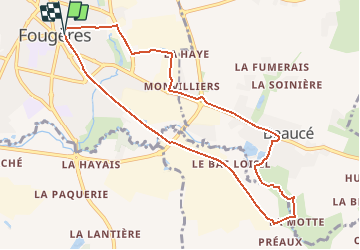
Tocht Mountainbike van 9,2 km beschikbaar op Bretagne, Ille-et-Vilaine, Fougères. Deze tocht wordt voorgesteld door tracegps.
Beschrijving
Boucle de 9 km au départ du cinéma de Fougères vers la commune de Beaucé et son magnifique plan d'eau et parcours le long de la rivière l'alimentant puis retour vers Fougères via l'ancienne voie de chemin de fer.
Plaatsbepaling
Land:
France
Regio :
Bretagne
Departement/Provincie :
Ille-et-Vilaine
Gemeente :
Fougères
Locatie:
Unknown
Vertrek:(Dec)
Vertrek:(UTM)
633800 ; 5356843 (30U) N.
Opmerkingen
Wandeltochten in de omgeving
![Tocht Te voet Landéan - Les Vieux Châteaux - Photo](https://media.geolcdn.com/t/375/260/ext.jpg?maxdim=2&url=https%3A%2F%2Fmedia.geolcdn.com%2Ff%2F122c427c-456b-4f47-979b-0a8d83dc03ab.jpeg)
![Te voet Te voet](https://static1.geolcdn.com/sitytour/trail-icons/100.png)
Les Vieux Châteaux
Te voet
Gemakkelijk
Landéan,
Bretagne,
Ille-et-Vilaine,
France
![](/images/other/stat-length.png)
5,3 km | 6,3 km-effort
1h 26min
![](https://static1.geolcdn.com/siteimages/upload/files/16400158638029165_repeat_loop_refresh_sync_direction_icon.png)
Ja
![Tocht Te voet Landéan - La Longue Noë - Photo](https://media.geolcdn.com/t/375/260/ext.jpg?maxdim=2&url=https%3A%2F%2Fmedia.geolcdn.com%2Ff%2Ff327ed77-355c-4519-bce4-a684f55ad906.jpeg)
![Te voet Te voet](https://static1.geolcdn.com/sitytour/trail-icons/100.png)
La Longue Noë
Te voet
Gemakkelijk
Landéan,
Bretagne,
Ille-et-Vilaine,
France
![](/images/other/stat-length.png)
6,2 km | 7,4 km-effort
1h 41min
![](https://static1.geolcdn.com/siteimages/upload/files/16400158638029165_repeat_loop_refresh_sync_direction_icon.png)
Ja
![Tocht Stappen Fougères - GR_37_AF_20_Fougeres_Chapelle-Janson_20210619 - Photo](https://media.geolcdn.com/t/375/260/ext.jpg?maxdim=2&url=https%3A%2F%2Fmedia.geolcdn.com%2Ff%2Fe8e1e45f-0996-4dce-a377-c3d0b42607e7.jpg)
![Stappen Stappen](https://static1.geolcdn.com/sitytour/trail-icons/101.png)
GR_37_AF_20_Fougeres_Chapelle-Janson_20210619
Stappen
Gemakkelijk
Fougères,
Bretagne,
Ille-et-Vilaine,
France
![](/images/other/stat-length.png)
9,9 km | 12,5 km-effort
2h 28min
![](https://static1.geolcdn.com/siteimages/upload/files/16400158638029165_repeat_loop_refresh_sync_direction_icon.png)
Neen
![Tocht Noords wandelen Landéan - chênedet Noë st françois 11km - Photo](https://media.geolcdn.com/t/375/260/ext.jpg?maxdim=2&url=https%3A%2F%2Fstatic1.geolcdn.com%2Fsiteimages%2Fupload%2Ffiles%2F1545311037marcheuse_200dpi.jpg)
![Noords wandelen Noords wandelen](https://static1.geolcdn.com/sitytour/trail-icons/102.png)
chênedet Noë st françois 11km
Noords wandelen
Medium
(1)
Landéan,
Bretagne,
Ille-et-Vilaine,
France
![](/images/other/stat-length.png)
11,4 km | 13,7 km-effort
2h 0min
![](https://static1.geolcdn.com/siteimages/upload/files/16400158638029165_repeat_loop_refresh_sync_direction_icon.png)
Ja
![Tocht Noords wandelen Fougères - nançon chênedet long 18km - Photo](https://media.geolcdn.com/t/375/260/ext.jpg?maxdim=2&url=https%3A%2F%2Fstatic1.geolcdn.com%2Fsiteimages%2Fupload%2Ffiles%2F1545311037marcheuse_200dpi.jpg)
![Noords wandelen Noords wandelen](https://static1.geolcdn.com/sitytour/trail-icons/102.png)
nançon chênedet long 18km
Noords wandelen
Gemakkelijk
(1)
Fougères,
Bretagne,
Ille-et-Vilaine,
France
![](/images/other/stat-length.png)
18,1 km | 21 km-effort
3h 0min
![](https://static1.geolcdn.com/siteimages/upload/files/16400158638029165_repeat_loop_refresh_sync_direction_icon.png)
Ja
![Tocht Noords wandelen Fougères - grolay nichecoucou GR34 19km - Photo](https://media.geolcdn.com/t/375/260/ext.jpg?maxdim=2&url=https%3A%2F%2Fstatic1.geolcdn.com%2Fsiteimages%2Fupload%2Ffiles%2F1545311037marcheuse_200dpi.jpg)
![Noords wandelen Noords wandelen](https://static1.geolcdn.com/sitytour/trail-icons/102.png)
grolay nichecoucou GR34 19km
Noords wandelen
Medium
(1)
Fougères,
Bretagne,
Ille-et-Vilaine,
France
![](/images/other/stat-length.png)
19,2 km | 24 km-effort
3h 20min
![](https://static1.geolcdn.com/siteimages/upload/files/16400158638029165_repeat_loop_refresh_sync_direction_icon.png)
Ja
![Tocht Noords wandelen Landéan - Poulailler autour du Moulin d'Avion 12,5km - Photo](https://media.geolcdn.com/t/375/260/ext.jpg?maxdim=2&url=https%3A%2F%2Fservices.sitytrail.com%2FGeolivesWS%2FDownloadMedia.ashx%3FTrailID%3D676451%26Media%3Dcc3eee66-6e8e-4acd-8735-e9a30f06fcf1.jpeg)
![Noords wandelen Noords wandelen](https://static1.geolcdn.com/sitytour/trail-icons/102.png)
Poulailler autour du Moulin d'Avion 12,5km
Noords wandelen
Medium
Landéan,
Bretagne,
Ille-et-Vilaine,
France
![](/images/other/stat-length.png)
12,5 km | 14,9 km-effort
2h 10min
![](https://static1.geolcdn.com/siteimages/upload/files/16400158638029165_repeat_loop_refresh_sync_direction_icon.png)
Ja
![Tocht Noords wandelen Landéan - Poulailler Chénedet 10,4km - Photo](https://media.geolcdn.com/t/375/260/ext.jpg?maxdim=2&url=https%3A%2F%2Fservices.sitytrail.com%2FGeolivesWS%2FDownloadMedia.ashx%3FTrailID%3D676433%26Media%3Dc418e412-7874-4576-9726-02eef27b2c32.jpg)
![Noords wandelen Noords wandelen](https://static1.geolcdn.com/sitytour/trail-icons/102.png)
Poulailler Chénedet 10,4km
Noords wandelen
Medium
Landéan,
Bretagne,
Ille-et-Vilaine,
France
![](/images/other/stat-length.png)
10,3 km | 12,5 km-effort
2h 50min
![](https://static1.geolcdn.com/siteimages/upload/files/16400158638029165_repeat_loop_refresh_sync_direction_icon.png)
Ja
![Tocht Noords wandelen Landéan - CMN Albert 10km - Photo](https://media.geolcdn.com/t/375/260/ext.jpg?maxdim=2&url=https%3A%2F%2Fservices.sitytrail.com%2FGeolivesWS%2FDownloadMedia.ashx%3FTrailID%3D189602%26Media%3D27502648-31d9-4ef3-b6ad-5dd7e3ce8752.jpg)
![Noords wandelen Noords wandelen](https://static1.geolcdn.com/sitytour/trail-icons/102.png)
CMN Albert 10km
Noords wandelen
Medium
Landéan,
Bretagne,
Ille-et-Vilaine,
France
![](/images/other/stat-length.png)
9,9 km | 12 km-effort
1h 40min
![](https://static1.geolcdn.com/siteimages/upload/files/16400158638029165_repeat_loop_refresh_sync_direction_icon.png)
Ja