![](/images/other/stat-length.png)
![Tocht Stappen Villeperdrix - Montagne d'Angèle - Photo](https://media.geolcdn.com/t/1900/400/ext.pjpeg?maxdim=2&url=https%3A%2F%2Fservices.sitytrail.com%2FGeolivesWS%2FDownloadMedia.ashx%3FTrailID%3D104539%26Media%3D7884_4.jpg)
Montagne d'Angèle
tracegps
Gebruiker
![Lengte](/images/other/stat-length.png)
![Max. hoogte](https://static1.geolcdn.com/siteimages/upload/files/1508320355ic_sort_altitude_max_24dp.png)
![Positief hoogteverschil](https://static1.geolcdn.com/siteimages/upload/files/1508320355ic_sort_den_pos_24dp.png)
![Km-Effort](/images/other/stat-length.png)
![Min. hoogte](https://static1.geolcdn.com/siteimages/upload/files/1508320355ic_sort_altitude_min_24dp.png)
![Negatief hoogteverschil](https://static1.geolcdn.com/siteimages/upload/files/1508320355ic_sort_den_neg_24dp.png)
![Boucle](https://static1.geolcdn.com/siteimages/upload/files/16400158638029165_repeat_loop_refresh_sync_direction_icon.png)
![Stappen](https://static1.geolcdn.com/sitytour/trail-icons/101.png)
3h30
Moeilijkheid : Moeilijk
![Scan deze QR-code om de tocht te openen in de SityTrail-applicatie](https://capi.geolives.com/qq0zvz2zws4bq2lad0pu/sitytour/trails/104539/qr.png?size=200)
Gratisgps-wandelapplicatie
Over ons
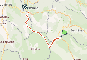
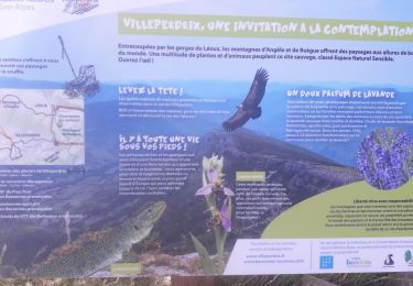
Tocht Stappen van 8,6 km beschikbaar op Auvergne-Rhône-Alpes, Drôme, Villeperdrix. Deze tocht wordt voorgesteld door tracegps.
Beschrijving
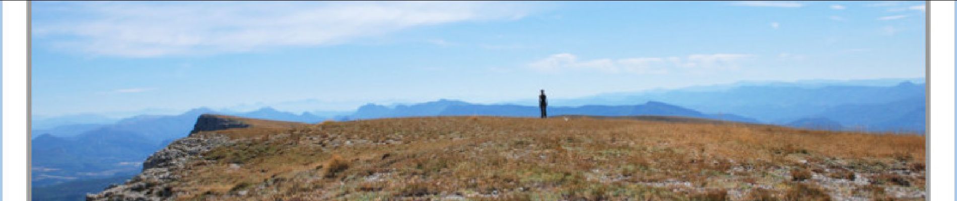
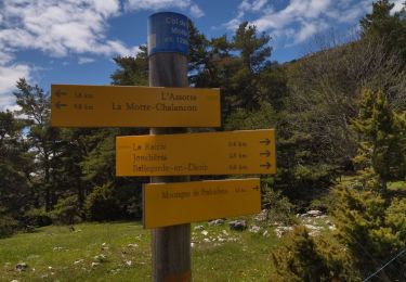
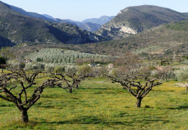
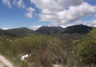
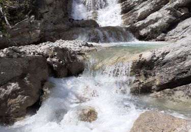
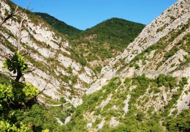
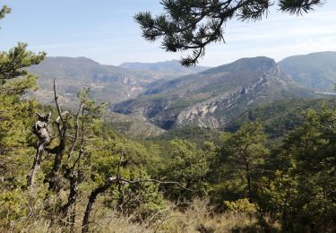
Attention cette montagne est un espace ou l'été paissent les troupeaux de moutons. Suite aux problèmes causés par des randonneurs inconséquents (chiens en liberté, enfants et aussi adultes semant la panique dans les troupeaux), il faut demander l'autorisation de passage au berger, se renseigner auprès du syndicat d'initiative de La motte Chalancon. Partant du col de la Pertie le chemin monte assez rapidement au milieu d'un bois de feuillus. Une halte en passant devant une bergerie en ruine (vue sur la vallée d'Arnayon (photo 1). Le chemin se poursuit à flan de montagne jusqu'au col de pierre Blanche (Photo 2) a partir de là deux solutions couper à travers le plateau pour rejoindre, le Rocher du Merlu, point culminant (chemin de la trace GPS) ou longer les crêtes. La deuxième solution est la plus belle mais allonge de façon significative le trajet (une heure environ). Au sommet vue à 360° superbe. Pour le retour il faudra faire bien attention à suivre le chemin à peine tracé au centre de la prairie. On rejoint des bois et enfin le Col de Lescou.
Plaatsbepaling
Opmerkingen
Wandeltochten in de omgeving
![Tocht Stappen Chalancon - 26 eyriau - Photo](https://media.geolcdn.com/t/375/260/7f70cd36-a3d0-48cb-b54c-083b90637d61.jpg&format=jpg&maxdim=2)
![Stappen Stappen](https://static1.geolcdn.com/sitytour/trail-icons/101.png)
Stappen
![](/images/other/stat-length.png)
![](https://static1.geolcdn.com/siteimages/upload/files/16400158638029165_repeat_loop_refresh_sync_direction_icon.png)
![Tocht Stappen Villeperdrix - Villeperdrix-L'Angèle 13km - Photo](https://media.geolcdn.com/t/375/260/d0108719-7d5a-469c-a1d1-c0d5df953c3b.jpg&format=jpg&maxdim=2)
![Stappen Stappen](https://static1.geolcdn.com/sitytour/trail-icons/101.png)
Stappen
![](/images/other/stat-length.png)
![](https://static1.geolcdn.com/siteimages/upload/files/16400158638029165_repeat_loop_refresh_sync_direction_icon.png)
![Tocht Stappen Gumiane - Angèle - Photo](https://media.geolcdn.com/t/375/260/4a109e75-c91a-41b5-b20f-b684de899b3e.jpg&format=jpg&maxdim=2)
![Stappen Stappen](https://static1.geolcdn.com/sitytour/trail-icons/101.png)
Stappen
![](/images/other/stat-length.png)
![](https://static1.geolcdn.com/siteimages/upload/files/16400158638029165_repeat_loop_refresh_sync_direction_icon.png)
![Tocht Stappen Chalancon - Chalancon (26)Montagne Eyriau - Photo](https://media.geolcdn.com/t/375/260/e1e7d64c-ae8c-44c1-bef1-46573e2ead16.jpg&format=jpg&maxdim=2)
![Stappen Stappen](https://static1.geolcdn.com/sitytour/trail-icons/101.png)
Stappen
![](/images/other/stat-length.png)
![](https://static1.geolcdn.com/siteimages/upload/files/16400158638029165_repeat_loop_refresh_sync_direction_icon.png)
![Tocht Stappen Gumiane - le Merlu - Photo](https://media.geolcdn.com/t/375/260/519ae12a-4541-459c-99dd-41c709c1a9c7.jpg&format=jpg&maxdim=2)
![Stappen Stappen](https://static1.geolcdn.com/sitytour/trail-icons/101.png)
Stappen
![](/images/other/stat-length.png)
![](https://static1.geolcdn.com/siteimages/upload/files/16400158638029165_repeat_loop_refresh_sync_direction_icon.png)
![Tocht Stappen Arnayon - Chamousset - Photo](https://media.geolcdn.com/t/375/260/ext.jpg?maxdim=2&url=https%3A%2F%2Fservices.sitytrail.com%2FGeolivesWS%2FDownloadMedia.ashx%3FTrailID%3D104451%26Media%3D7704_6.jpg)
![Stappen Stappen](https://static1.geolcdn.com/sitytour/trail-icons/101.png)
Stappen
![](/images/other/stat-length.png)
![](https://static1.geolcdn.com/siteimages/upload/files/16400158638029165_repeat_loop_refresh_sync_direction_icon.png)
![Tocht Stappen Villeperdrix - villeperdrix, terrasses de l'eygues - Photo](https://media.geolcdn.com/t/375/260/5af7ed38-4d03-49ca-bf5f-eb10434d4649.jpg&format=jpg&maxdim=2)
![Stappen Stappen](https://static1.geolcdn.com/sitytour/trail-icons/101.png)
Stappen
![](/images/other/stat-length.png)
![](https://static1.geolcdn.com/siteimages/upload/files/16400158638029165_repeat_loop_refresh_sync_direction_icon.png)
![Tocht Stappen Villeperdrix - l angele - Photo](https://media.geolcdn.com/t/375/260/19ae0a51-c702-4e46-81d7-485676509146.jpg&format=jpg&maxdim=2)
![Stappen Stappen](https://static1.geolcdn.com/sitytour/trail-icons/101.png)
Stappen
![](/images/other/stat-length.png)
![](https://static1.geolcdn.com/siteimages/upload/files/16400158638029165_repeat_loop_refresh_sync_direction_icon.png)
![Tocht Stappen Villeperdrix - villeperdrix - Photo](https://media.geolcdn.com/t/375/260/1405a225-10b5-419e-a02f-c29799e378ca.jpg&format=jpg&maxdim=2)
![Stappen Stappen](https://static1.geolcdn.com/sitytour/trail-icons/101.png)
Stappen
![](/images/other/stat-length.png)
![](https://static1.geolcdn.com/siteimages/upload/files/16400158638029165_repeat_loop_refresh_sync_direction_icon.png)
Dommage qu'il faille s'abonner au bout d'une semaine, sinon très bonne application pour faire de la randonnée/ VTT/coures à pied etc.. je recommande.