![](/images/other/stat-length.png)
![Tocht Lopen Rennes - Rennes Sud 17,24km - Photo](https://media.geolcdn.com/t/1900/400/ext.pjpeg?maxdim=2&url=https%3A%2F%2Fstatic1.geolcdn.com%2Fsiteimages%2Fupload%2Ffiles%2F1524743154running.jpg)
Rennes Sud 17,24km
tracegps
Gebruiker
![Lengte](/images/other/stat-length.png)
![Max. hoogte](https://static1.geolcdn.com/siteimages/upload/files/1508320355ic_sort_altitude_max_24dp.png)
![Positief hoogteverschil](https://static1.geolcdn.com/siteimages/upload/files/1508320355ic_sort_den_pos_24dp.png)
![Km-Effort](/images/other/stat-length.png)
![Min. hoogte](https://static1.geolcdn.com/siteimages/upload/files/1508320355ic_sort_altitude_min_24dp.png)
![Negatief hoogteverschil](https://static1.geolcdn.com/siteimages/upload/files/1508320355ic_sort_den_neg_24dp.png)
![Boucle](https://static1.geolcdn.com/siteimages/upload/files/16400158638029165_repeat_loop_refresh_sync_direction_icon.png)
![Lopen](https://static1.geolcdn.com/sitytour/trail-icons/103.png)
2h00
Moeilijkheid : Moeilijk
![Scan deze QR-code om de tocht te openen in de SityTrail-applicatie](https://capi.geolives.com/qq0zvz2zws4bq2lad0pu/sitytour/trails/104490/qr.png?size=200)
Gratisgps-wandelapplicatie
Over ons
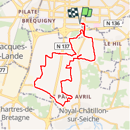
Tocht Lopen van 17,2 km beschikbaar op Bretagne, Ille-et-Vilaine, Rennes. Deze tocht wordt voorgesteld door tracegps.
Beschrijving
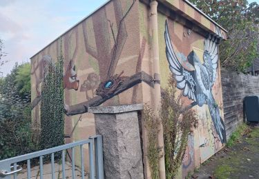
Parcours de 17km au Sud de Rennes, alternant bitume et sentiers plus ou moins boueux. Chaussures de Trail étanches conseillées. Plusieurs passages confusant (Le Pré Noé ou il faut passer par le corps de ferme puis ne pas rater l'embranchement vers la route au risque de finir dans un champ). Au final une belle balade au milieu de la campagne et quelques fois des champs.
Plaatsbepaling
Opmerkingen
Wandeltochten in de omgeving
![Tocht Te voet Noyal-Châtillon-sur-Seiche - Circuit de La Touche - Photo](https://media.geolcdn.com/t/375/260/7245a798-ca86-46f2-b09b-f9ae115c83bc.jpeg&format=jpg&maxdim=2)
![Te voet Te voet](https://static1.geolcdn.com/sitytour/trail-icons/100.png)
Te voet
![](/images/other/stat-length.png)
![](https://static1.geolcdn.com/siteimages/upload/files/16400158638029165_repeat_loop_refresh_sync_direction_icon.png)
![Tocht Te voet Noyal-Châtillon-sur-Seiche - Circuit de l'Orson - Photo](https://media.geolcdn.com/t/375/260/a2aeca72-a9e7-4b01-b153-4bb910768de8.jpeg&format=jpg&maxdim=2)
![Te voet Te voet](https://static1.geolcdn.com/sitytour/trail-icons/100.png)
Te voet
![](/images/other/stat-length.png)
![](https://static1.geolcdn.com/siteimages/upload/files/16400158638029165_repeat_loop_refresh_sync_direction_icon.png)
![Tocht Te voet Rennes - La balade à André - Photo](https://media.geolcdn.com/t/375/260/21bf6cca-cebe-47ea-8c50-7b46a79e5fa3.jpeg&format=jpg&maxdim=2)
![Te voet Te voet](https://static1.geolcdn.com/sitytour/trail-icons/100.png)
Te voet
![](/images/other/stat-length.png)
![](https://static1.geolcdn.com/siteimages/upload/files/16400158638029165_repeat_loop_refresh_sync_direction_icon.png)
![Tocht Te voet Noyal-Châtillon-sur-Seiche - Circuit de Champagné - Photo](https://media.geolcdn.com/t/375/260/f7afdba8-6ab9-4d0a-bc01-e7693cf14182.jpeg&format=jpg&maxdim=2)
![Te voet Te voet](https://static1.geolcdn.com/sitytour/trail-icons/100.png)
Te voet
![](/images/other/stat-length.png)
![](https://static1.geolcdn.com/siteimages/upload/files/16400158638029165_repeat_loop_refresh_sync_direction_icon.png)
![Tocht Te voet Cesson-Sévigné - Parcs et jardins - Photo](https://media.geolcdn.com/t/375/260/037007ff-9a46-424d-a033-bc4b6ff71a6a.jpeg&format=jpg&maxdim=2)
![Te voet Te voet](https://static1.geolcdn.com/sitytour/trail-icons/100.png)
Te voet
![](/images/other/stat-length.png)
![](https://static1.geolcdn.com/siteimages/upload/files/16400158638029165_repeat_loop_refresh_sync_direction_icon.png)
![Tocht Stappen Cesson-Sévigné - Cesson Sévigné - Photo](https://media.geolcdn.com/t/375/260/ext.jpg?maxdim=2&url=https%3A%2F%2Fstatic1.geolcdn.com%2Fsiteimages%2Fupload%2Ffiles%2F1553511878bg_sport_marche.png)
![Stappen Stappen](https://static1.geolcdn.com/sitytour/trail-icons/101.png)
Stappen
![](/images/other/stat-length.png)
![](https://static1.geolcdn.com/siteimages/upload/files/16400158638029165_repeat_loop_refresh_sync_direction_icon.png)
![Tocht Stappen Rennes - La promenade Georges Brassens et des Bonnets Rouges - Rennes - Photo](https://media.geolcdn.com/t/375/260/ext.jpg?maxdim=2&url=https%3A%2F%2Fservices.sitytrail.com%2FGeolivesWS%2FDownloadMedia.ashx%3FTrailID%3D191412%26Media%3D14992_6.jpg)
![Stappen Stappen](https://static1.geolcdn.com/sitytour/trail-icons/101.png)
Stappen
![](/images/other/stat-length.png)
![](https://static1.geolcdn.com/siteimages/upload/files/16400158638029165_repeat_loop_refresh_sync_direction_icon.png)
![Tocht Te voet Rennes - RENNES : street art raccourci le 18/11/2024 - Photo](https://media.geolcdn.com/t/375/260/51742e12-aee2-4c99-96cd-a0fc410ef54f.jpg&format=jpg&maxdim=2)
![Te voet Te voet](https://static1.geolcdn.com/sitytour/trail-icons/100.png)
Te voet
![](/images/other/stat-length.png)
![](https://static1.geolcdn.com/siteimages/upload/files/16400158638029165_repeat_loop_refresh_sync_direction_icon.png)
![Tocht Elektrische fiets Rennes - Rennes à Guipry-Messac - Photo](https://media.geolcdn.com/t/375/260/2b36141b-c92e-475f-a12d-aab1f02c06c0.jpg&format=jpg&maxdim=2)
![Elektrische fiets Elektrische fiets](https://static1.geolcdn.com/sitytour/trail-icons/205.png)
Elektrische fiets
![](/images/other/stat-length.png)
![](https://static1.geolcdn.com/siteimages/upload/files/16400158638029165_repeat_loop_refresh_sync_direction_icon.png)