![](/images/other/stat-length.png)
![Tocht Fiets Bruz - Route Bruz - Chavagne - Ker Lann-23km - Photo](https://media.geolcdn.com/t/1900/400/ext.pjpeg?maxdim=2&url=https%3A%2F%2Fstatic1.geolcdn.com%2Fsiteimages%2Fupload%2Ffiles%2F1524743154velo.jpg)
Route Bruz - Chavagne - Ker Lann-23km
tracegps
Gebruiker
![Lengte](/images/other/stat-length.png)
Lengte
23 km
![Max. hoogte](https://static1.geolcdn.com/siteimages/upload/files/1508320355ic_sort_altitude_max_24dp.png)
Max. hoogte
44 m
![Positief hoogteverschil](https://static1.geolcdn.com/siteimages/upload/files/1508320355ic_sort_den_pos_24dp.png)
Positief hoogteverschil
168 m
![Km-Effort](/images/other/stat-length.png)
Km-Effort
25 km
![Min. hoogte](https://static1.geolcdn.com/siteimages/upload/files/1508320355ic_sort_altitude_min_24dp.png)
Min. hoogte
15 m
![Negatief hoogteverschil](https://static1.geolcdn.com/siteimages/upload/files/1508320355ic_sort_den_neg_24dp.png)
Negatief hoogteverschil
173 m
![Boucle](https://static1.geolcdn.com/siteimages/upload/files/16400158638029165_repeat_loop_refresh_sync_direction_icon.png)
Boucle
Neen
Datum van aanmaak :
2014-12-10 00:00:00.0
Laatste wijziging :
2014-12-10 00:00:00.0
![Fiets](https://static1.geolcdn.com/sitytour/trail-icons/200.png)
1h00
Moeilijkheid : Medium
![Scan deze QR-code om de tocht te openen in de SityTrail-applicatie](https://capi.geolives.com/qq0zvz2zws4bq2lad0pu/sitytour/trails/104489/qr.png?size=200)
Gratisgps-wandelapplicatie
Over ons
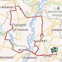
Tocht Fiets van 23 km beschikbaar op Bretagne, Ille-et-Vilaine, Bruz. Deze tocht wordt voorgesteld door tracegps.
Beschrijving
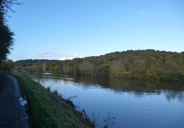
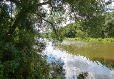
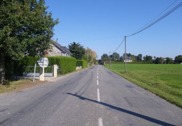
Parcours en boucle au départ de Bruz. Circuit agréable, petites routes au revêtement tout à fait correct. Un passage ou 2 près des fermes peut laisser de la boue sur la route. Parcourt plat sans aucun difficulté.
Plaatsbepaling
Land:
France
Regio :
Bretagne
Departement/Provincie :
Ille-et-Vilaine
Gemeente :
Bruz
Locatie:
Unknown
Vertrek:(Dec)
Vertrek:(UTM)
593850 ; 5319872 (30U) N.
Opmerkingen
Wandeltochten in de omgeving
![Tocht Mountainbike Pont-Péan - Le long de la Vilaine - Pont Péan - Photo](https://media.geolcdn.com/t/375/260/ext.jpg?maxdim=2&url=https%3A%2F%2Fservices.sitytrail.com%2FGeolivesWS%2FDownloadMedia.ashx%3FTrailID%3D214889%26Media%3D15441_3.jpg)
![Mountainbike Mountainbike](https://static1.geolcdn.com/sitytour/trail-icons/202.png)
Le long de la Vilaine - Pont Péan
Mountainbike
Moeilijk
(1)
Pont-Péan,
Bretagne,
Ille-et-Vilaine,
France
![](/images/other/stat-length.png)
35 km | 41 km-effort
2h 15min
![](https://static1.geolcdn.com/siteimages/upload/files/16400158638029165_repeat_loop_refresh_sync_direction_icon.png)
Ja
![Tocht Stappen Pont-Péan - Randonnée autour de Pont-Péan - Photo](https://media.geolcdn.com/t/375/260/ext.jpg?maxdim=2&url=https%3A%2F%2Fservices.sitytrail.com%2FGeolivesWS%2FDownloadMedia.ashx%3FTrailID%3D191361%26Media%3D14926_3.jpg)
![Stappen Stappen](https://static1.geolcdn.com/sitytour/trail-icons/101.png)
Randonnée autour de Pont-Péan
Stappen
Medium
(1)
Pont-Péan,
Bretagne,
Ille-et-Vilaine,
France
![](/images/other/stat-length.png)
7,9 km | 8,5 km-effort
2h 0min
![](https://static1.geolcdn.com/siteimages/upload/files/16400158638029165_repeat_loop_refresh_sync_direction_icon.png)
Ja
![Tocht Te voet Laillé - Laillé la Chapelle - Photo](https://media.geolcdn.com/t/375/260/80425336-5829-4a9b-bf94-af8dc6722242.jpeg&format=jpg&maxdim=2)
![Te voet Te voet](https://static1.geolcdn.com/sitytour/trail-icons/100.png)
Laillé la Chapelle
Te voet
Gemakkelijk
Laillé,
Bretagne,
Ille-et-Vilaine,
France
![](/images/other/stat-length.png)
13,2 km | 15,6 km-effort
3h 33min
![](https://static1.geolcdn.com/siteimages/upload/files/16400158638029165_repeat_loop_refresh_sync_direction_icon.png)
Ja
![Tocht Te voet Guichen - Les landes du Boël - Photo](https://media.geolcdn.com/t/375/260/1813c78e-bc32-4e6c-94ee-9a2d64ec30b9.jpeg&format=jpg&maxdim=2)
![Te voet Te voet](https://static1.geolcdn.com/sitytour/trail-icons/100.png)
Les landes du Boël
Te voet
Gemakkelijk
Guichen,
Bretagne,
Ille-et-Vilaine,
France
![](/images/other/stat-length.png)
5,2 km | 6,1 km-effort
1h 23min
![](https://static1.geolcdn.com/siteimages/upload/files/16400158638029165_repeat_loop_refresh_sync_direction_icon.png)
Ja
![Tocht Te voet Guichen - Les bords de Vilaine - Photo](https://media.geolcdn.com/t/375/260/8b284707-f183-43bc-8580-95dab992180f.jpeg&format=jpg&maxdim=2)
![Te voet Te voet](https://static1.geolcdn.com/sitytour/trail-icons/100.png)
Les bords de Vilaine
Te voet
Gemakkelijk
Guichen,
Bretagne,
Ille-et-Vilaine,
France
![](/images/other/stat-length.png)
6,9 km | 8,4 km-effort
1h 54min
![](https://static1.geolcdn.com/siteimages/upload/files/16400158638029165_repeat_loop_refresh_sync_direction_icon.png)
Ja
![Tocht Te voet Guichen - Pont-Réan Le Boël - Photo](https://media.geolcdn.com/t/375/260/e213902f-f4f2-441e-8674-df4f61e7aed3.jpeg&format=jpg&maxdim=2)
![Te voet Te voet](https://static1.geolcdn.com/sitytour/trail-icons/100.png)
Pont-Réan Le Boël
Te voet
Gemakkelijk
Guichen,
Bretagne,
Ille-et-Vilaine,
France
![](/images/other/stat-length.png)
9,3 km | 11,5 km-effort
2h 37min
![](https://static1.geolcdn.com/siteimages/upload/files/16400158638029165_repeat_loop_refresh_sync_direction_icon.png)
Ja
![Tocht Stappen Laillé - Laillé, Roche qui chome - Photo](https://media.geolcdn.com/t/375/260/420863b8-58d5-4ae8-816c-3f076cdd0c92.jpg&format=jpg&maxdim=2)
![Stappen Stappen](https://static1.geolcdn.com/sitytour/trail-icons/101.png)
Laillé, Roche qui chome
Stappen
Heel gemakkelijk
Laillé,
Bretagne,
Ille-et-Vilaine,
France
![](/images/other/stat-length.png)
11,4 km | 13,1 km-effort
2h 40min
![](https://static1.geolcdn.com/siteimages/upload/files/16400158638029165_repeat_loop_refresh_sync_direction_icon.png)
Ja
![Tocht Stappen Guichen - pont rean - Photo](https://media.geolcdn.com/t/375/260/65f98fc0-d3d5-4bdf-9405-7defdae3d94b.jpg&format=jpg&maxdim=2)
![Stappen Stappen](https://static1.geolcdn.com/sitytour/trail-icons/101.png)
pont rean
Stappen
Medium
Guichen,
Bretagne,
Ille-et-Vilaine,
France
![](/images/other/stat-length.png)
9,2 km | 11,4 km-effort
2h 22min
![](https://static1.geolcdn.com/siteimages/upload/files/16400158638029165_repeat_loop_refresh_sync_direction_icon.png)
Ja
![Tocht Stappen Bruz - Boucle Le Boël - gare de Laillé - Photo](https://media.geolcdn.com/t/375/260/611caf29-d097-4739-8fb1-bb9fe7b2198f.jpg&format=jpg&maxdim=2)
![Stappen Stappen](https://static1.geolcdn.com/sitytour/trail-icons/101.png)
Boucle Le Boël - gare de Laillé
Stappen
Medium
Bruz,
Bretagne,
Ille-et-Vilaine,
France
![](/images/other/stat-length.png)
8,4 km | 10 km-effort
2h 22min
![](https://static1.geolcdn.com/siteimages/upload/files/16400158638029165_repeat_loop_refresh_sync_direction_icon.png)
Ja