![](/images/other/stat-length.png)
![Tocht Stappen Arnayon - Chamousset - Photo](https://media.geolcdn.com/t/1900/400/ext.pjpeg?maxdim=2&url=https%3A%2F%2Fservices.sitytrail.com%2FGeolivesWS%2FDownloadMedia.ashx%3FTrailID%3D104451%26Media%3D7704_6.jpg)
Chamousset
tracegps
Gebruiker
![Lengte](/images/other/stat-length.png)
![Max. hoogte](https://static1.geolcdn.com/siteimages/upload/files/1508320355ic_sort_altitude_max_24dp.png)
![Positief hoogteverschil](https://static1.geolcdn.com/siteimages/upload/files/1508320355ic_sort_den_pos_24dp.png)
![Km-Effort](/images/other/stat-length.png)
![Min. hoogte](https://static1.geolcdn.com/siteimages/upload/files/1508320355ic_sort_altitude_min_24dp.png)
![Negatief hoogteverschil](https://static1.geolcdn.com/siteimages/upload/files/1508320355ic_sort_den_neg_24dp.png)
![Boucle](https://static1.geolcdn.com/siteimages/upload/files/16400158638029165_repeat_loop_refresh_sync_direction_icon.png)
![Stappen](https://static1.geolcdn.com/sitytour/trail-icons/101.png)
2h30
Moeilijkheid : Medium
![Scan deze QR-code om de tocht te openen in de SityTrail-applicatie](https://capi.geolives.com/qq0zvz2zws4bq2lad0pu/sitytour/trails/104451/qr.png?size=200)
Gratisgps-wandelapplicatie
Over ons
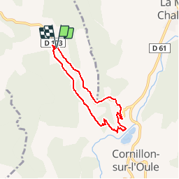
Tocht Stappen van 5,9 km beschikbaar op Auvergne-Rhône-Alpes, Drôme, Arnayon. Deze tocht wordt voorgesteld door tracegps.
Beschrijving
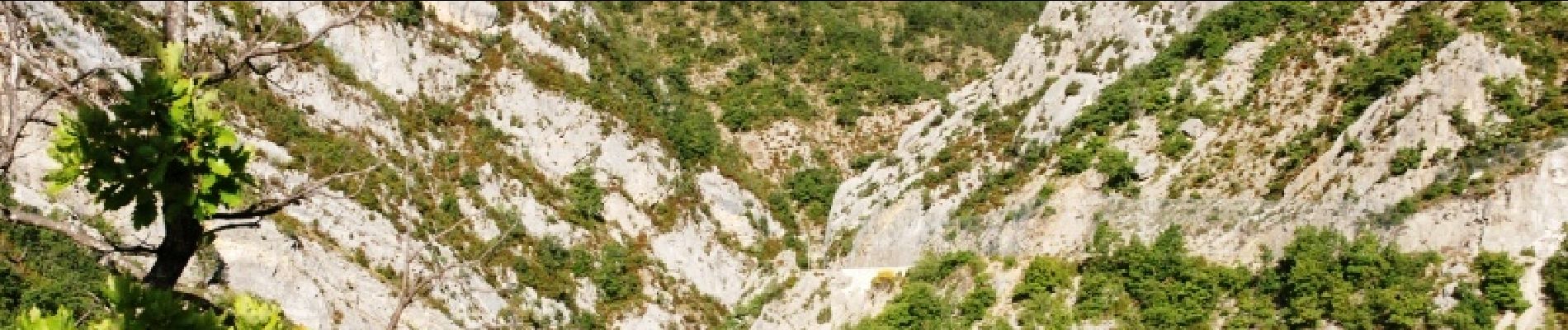
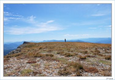
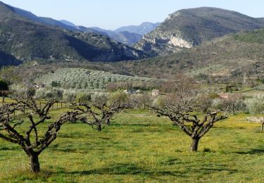
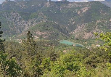
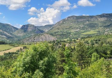
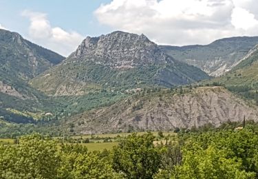
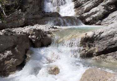
Difficultés: Un chemin par moment très étroit qui surplombe la rivière d’Arnayon, quelques passages impressionnants là où le chemin devient presque inexistant lors de passage d’éboulis. La descente sur les lacs est raide. Au point de départ, on peu se garer au début du chemin le long de la route. Le chemin surplombe la route, une belle vue sur la montagne de Longe Serre et sa formation géologique (dalle d'Arnayon)(1). A la fin du chemin longeant le flanc de la montagne, une très belle vue sur le "Pas des Ondes" étroit couloir où se faufile la rivière Oule (2). En face se dressent les ruines du Château de Cornillon un ancien château fort (3). Pendant la descente, assez raide, vue sur le "plan d'eau" et le petit village de Cornillon(4) ainsi que le village de La Motte Chalancon et la vallée de l'Oule (5). Il faudra reprendre sur environ 2 km une route qui serpente dans les gorges d'Arnayon, une site superbe que l'on ne peut vraiment apprécier qu'à pied(6).
Plaatsbepaling
Opmerkingen
Wandeltochten in de omgeving
![Tocht Stappen Villeperdrix - Montagne d'Angèle - Photo](https://media.geolcdn.com/t/375/260/ext.jpg?maxdim=2&url=https%3A%2F%2Fservices.sitytrail.com%2FGeolivesWS%2FDownloadMedia.ashx%3FTrailID%3D104539%26Media%3D7884_4.jpg)
![Stappen Stappen](https://static1.geolcdn.com/sitytour/trail-icons/101.png)
Stappen
![](/images/other/stat-length.png)
![](https://static1.geolcdn.com/siteimages/upload/files/16400158638029165_repeat_loop_refresh_sync_direction_icon.png)
![Tocht Stappen Chalancon - 26 eyriau - Photo](https://media.geolcdn.com/t/375/260/7f70cd36-a3d0-48cb-b54c-083b90637d61.jpg&format=jpg&maxdim=2)
![Stappen Stappen](https://static1.geolcdn.com/sitytour/trail-icons/101.png)
Stappen
![](/images/other/stat-length.png)
![](https://static1.geolcdn.com/siteimages/upload/files/16400158638029165_repeat_loop_refresh_sync_direction_icon.png)
![Tocht Stappen Villeperdrix - Villeperdrix-L'Angèle 13km - Photo](https://media.geolcdn.com/t/375/260/d0108719-7d5a-469c-a1d1-c0d5df953c3b.jpg&format=jpg&maxdim=2)
![Stappen Stappen](https://static1.geolcdn.com/sitytour/trail-icons/101.png)
Stappen
![](/images/other/stat-length.png)
![](https://static1.geolcdn.com/siteimages/upload/files/16400158638029165_repeat_loop_refresh_sync_direction_icon.png)
![Tocht Stappen La Motte-Chalancon - Boucle à Cornillon - Photo](https://media.geolcdn.com/t/375/260/68e11cbc-3244-4d5b-8d24-31101eb609ab.jpg&format=jpg&maxdim=2)
![Stappen Stappen](https://static1.geolcdn.com/sitytour/trail-icons/101.png)
Stappen
![](/images/other/stat-length.png)
![](https://static1.geolcdn.com/siteimages/upload/files/16400158638029165_repeat_loop_refresh_sync_direction_icon.png)
![Tocht Stappen La Motte-Chalancon - La Motte Chalancon - Plateau de la Chau - Photo](https://media.geolcdn.com/t/375/260/5f397974-316e-44d5-952e-803b0bd6736b.jpg&format=jpg&maxdim=2)
![Stappen Stappen](https://static1.geolcdn.com/sitytour/trail-icons/101.png)
Stappen
![](/images/other/stat-length.png)
![](https://static1.geolcdn.com/siteimages/upload/files/16400158638029165_repeat_loop_refresh_sync_direction_icon.png)
![Tocht Stappen La Motte-Chalancon - LA MOTTE CHALANCON - LE PLATEAU DE LA CHAU - Photo](https://media.geolcdn.com/t/375/260/4f26d25d-f819-4267-a4ac-87b7f19efa5f.jpg&format=jpg&maxdim=2)
![Stappen Stappen](https://static1.geolcdn.com/sitytour/trail-icons/101.png)
Stappen
![](/images/other/stat-length.png)
![](https://static1.geolcdn.com/siteimages/upload/files/16400158638029165_repeat_loop_refresh_sync_direction_icon.png)
![Tocht Stappen Chalancon - Chalancon (26)Montagne Eyriau - Photo](https://media.geolcdn.com/t/375/260/e1e7d64c-ae8c-44c1-bef1-46573e2ead16.jpg&format=jpg&maxdim=2)
![Stappen Stappen](https://static1.geolcdn.com/sitytour/trail-icons/101.png)
Stappen
![](/images/other/stat-length.png)
![](https://static1.geolcdn.com/siteimages/upload/files/16400158638029165_repeat_loop_refresh_sync_direction_icon.png)
![Tocht Paard La Motte-Chalancon - DIOIS 3J J2 1605 - Photo](https://media.geolcdn.com/t/375/260/ext.jpg?maxdim=2&url=https%3A%2F%2Fstatic1.geolcdn.com%2Fsiteimages%2Fupload%2Ffiles%2F1524743154cheval.jpg)
![Paard Paard](https://static1.geolcdn.com/sitytour/trail-icons/300.png)
Paard
![](/images/other/stat-length.png)
![](https://static1.geolcdn.com/siteimages/upload/files/16400158638029165_repeat_loop_refresh_sync_direction_icon.png)
![Tocht Stappen La Motte-Chalancon - lac du pas des ondes-la motte chaloncon - Photo](https://media.geolcdn.com/t/375/260/ext.jpg?maxdim=2&url=https%3A%2F%2Fservices.sitytrail.com%2FGeolivesWS%2FDownloadMedia.ashx%3FTrailID%3D215403%26Media%3D20130820172336.jpg)
![Stappen Stappen](https://static1.geolcdn.com/sitytour/trail-icons/101.png)
Stappen
![](/images/other/stat-length.png)
![](https://static1.geolcdn.com/siteimages/upload/files/16400158638029165_repeat_loop_refresh_sync_direction_icon.png)