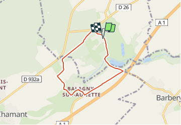
![](/images/other/stat-length.png)
![Tocht Stappen Villers-Saint-Frambourg-Ognon - MR_OGNON (par BALAGNY-sur-AUNETTE)_5.4Km - Photo](https://media.geolcdn.com/t/1900/400/faa42a0c-203b-4c6a-9068-84728c6debbe.jpg&format=pjpeg&maxdim=2)
MR_OGNON (par BALAGNY-sur-AUNETTE)_5.4Km
GOELE RANDO
Randonner avec bonne humeur et convivialité. (Inscription réservée uniquement aux animateurs de GOËLE RANDO)
![Lengte](/images/other/stat-length.png)
![Max. hoogte](https://static1.geolcdn.com/siteimages/upload/files/1508320355ic_sort_altitude_max_24dp.png)
![Positief hoogteverschil](https://static1.geolcdn.com/siteimages/upload/files/1508320355ic_sort_den_pos_24dp.png)
![Km-Effort](/images/other/stat-length.png)
![Min. hoogte](https://static1.geolcdn.com/siteimages/upload/files/1508320355ic_sort_altitude_min_24dp.png)
![Negatief hoogteverschil](https://static1.geolcdn.com/siteimages/upload/files/1508320355ic_sort_den_neg_24dp.png)
![Boucle](https://static1.geolcdn.com/siteimages/upload/files/16400158638029165_repeat_loop_refresh_sync_direction_icon.png)
![Stappen](https://static1.geolcdn.com/sitytour/trail-icons/101.png)
1h27
Moeilijkheid : Medium
![Scan deze QR-code om de tocht te openen in de SityTrail-applicatie](https://capi.geolives.com/qq0zvz2zws4bq2lad0pu/sitytour/trails/1043808/qr.png?size=200)
Gratisgps-wandelapplicatie
Over ons
Tocht Stappen van 5,4 km beschikbaar op Hauts-de-France, Oise, Villers-Saint-Frambourg-Ognon. Deze tocht wordt voorgesteld door GOELE RANDO.
Beschrijving
https://www.goelerando.fr/
DAMMARTIN en GOELE 77
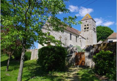
Parking derrière l'église de Villers St Frambourg-Ognon
Plaatsbepaling
Opmerkingen
Wandeltochten in de omgeving
![Tocht Stappen Mont-l'Évêque - SM_MONT-L'EVEQUE_8Km - Photo](https://media.geolcdn.com/t/375/260/c5d9fe69-6f06-4add-9173-2e50cb01e4b9.jpg&format=jpg&maxdim=2)
![Stappen Stappen](https://static1.geolcdn.com/sitytour/trail-icons/101.png)
Stappen
![](/images/other/stat-length.png)
![](https://static1.geolcdn.com/siteimages/upload/files/16400158638029165_repeat_loop_refresh_sync_direction_icon.png)
![Tocht Te voet Senlis - SENLIS CITE ROYALE(FFK) - Photo](https://media.geolcdn.com/t/375/260/542124cb-4295-4676-8208-e617d363b61b.jpg&format=jpg&maxdim=2)
![Te voet Te voet](https://static1.geolcdn.com/sitytour/trail-icons/100.png)
Te voet
![](/images/other/stat-length.png)
![](https://static1.geolcdn.com/siteimages/upload/files/16400158638029165_repeat_loop_refresh_sync_direction_icon.png)
![Tocht Stappen Fleurines - Fleurines Grand parcours - Photo](https://media.geolcdn.com/t/375/260/ext.jpg?maxdim=2&url=https%3A%2F%2Fstatic1.geolcdn.com%2Fsiteimages%2Fupload%2Ffiles%2F1553511878bg_sport_marche.png)
![Stappen Stappen](https://static1.geolcdn.com/sitytour/trail-icons/101.png)
Stappen
![](/images/other/stat-length.png)
![](https://static1.geolcdn.com/siteimages/upload/files/16400158638029165_repeat_loop_refresh_sync_direction_icon.png)
![Tocht Stappen Montépilloy - Montépilloy Supermini Rando - Photo](https://media.geolcdn.com/t/375/260/ext.jpg?maxdim=2&url=https%3A%2F%2Fstatic1.geolcdn.com%2Fsiteimages%2Fupload%2Ffiles%2F1553511878bg_sport_marche.png)
![Stappen Stappen](https://static1.geolcdn.com/sitytour/trail-icons/101.png)
Stappen
![](/images/other/stat-length.png)
![](https://static1.geolcdn.com/siteimages/upload/files/16400158638029165_repeat_loop_refresh_sync_direction_icon.png)
![Tocht Stappen Chamant - Chamant Supermini-rando - Photo](https://media.geolcdn.com/t/375/260/ext.jpg?maxdim=2&url=https%3A%2F%2Fstatic1.geolcdn.com%2Fsiteimages%2Fupload%2Ffiles%2F1553511878bg_sport_marche.png)
![Stappen Stappen](https://static1.geolcdn.com/sitytour/trail-icons/101.png)
Stappen
![](/images/other/stat-length.png)
![](https://static1.geolcdn.com/siteimages/upload/files/16400158638029165_repeat_loop_refresh_sync_direction_icon.png)
![Tocht Stappen Pontpoint - Mont Pagnotte Grand parcours - Photo](https://media.geolcdn.com/t/375/260/ext.jpg?maxdim=2&url=https%3A%2F%2Fstatic1.geolcdn.com%2Fsiteimages%2Fupload%2Ffiles%2F1553511878bg_sport_marche.png)
![Stappen Stappen](https://static1.geolcdn.com/sitytour/trail-icons/101.png)
Stappen
![](/images/other/stat-length.png)
![](https://static1.geolcdn.com/siteimages/upload/files/16400158638029165_repeat_loop_refresh_sync_direction_icon.png)
![Tocht Hybride fiets Fleurines - randonnée Au5v OT Ccpoh halatte - Photo](https://media.geolcdn.com/t/375/260/e4619b64-6ffd-453c-8063-35f7d7e4513e.jpg&format=jpg&maxdim=2)
![Hybride fiets Hybride fiets](https://static1.geolcdn.com/sitytour/trail-icons/203.png)
Hybride fiets
![](/images/other/stat-length.png)
![](https://static1.geolcdn.com/siteimages/upload/files/16400158638029165_repeat_loop_refresh_sync_direction_icon.png)
![Tocht Te voet Senlis - De Orrouy à Coye - Photo](https://media.geolcdn.com/t/375/260/e89a52f7-2fff-43c2-bfe0-60f4f3ab03ed.jpeg&format=jpg&maxdim=2)
![Te voet Te voet](https://static1.geolcdn.com/sitytour/trail-icons/100.png)
Te voet
![](/images/other/stat-length.png)
![](https://static1.geolcdn.com/siteimages/upload/files/16400158638029165_repeat_loop_refresh_sync_direction_icon.png)
![Tocht Stappen Villers-Saint-Frambourg-Ognon - SM_OGNON-(ex BALAGNY-sur-AUNETTE)_8.3Km - Photo](https://media.geolcdn.com/t/375/260/8470847c-163d-447b-bdc6-109cb2fcebb6.jpg&format=jpg&maxdim=2)
![Stappen Stappen](https://static1.geolcdn.com/sitytour/trail-icons/101.png)
Stappen
![](/images/other/stat-length.png)
![](https://static1.geolcdn.com/siteimages/upload/files/16400158638029165_repeat_loop_refresh_sync_direction_icon.png)
super, surtout à l'envers