![](/images/other/stat-length.png)
![Tocht Mountainbike Prats-de-Mollo-la-Preste - Espace VTT FFC Haut Vallespir - circuit n° 17 - Raid Transfrontalier - Photo](https://media.geolcdn.com/t/1900/400/ext.pjpeg?maxdim=2&url=https%3A%2F%2Fservices.sitytrail.com%2FGeolivesWS%2FDownloadMedia.ashx%3FTrailID%3D104355%26Media%3D7595_2.jpg)
Espace VTT FFC Haut Vallespir - circuit n° 17 - Raid Transfrontalier
tracegps
Gebruiker
![Lengte](/images/other/stat-length.png)
![Max. hoogte](https://static1.geolcdn.com/siteimages/upload/files/1508320355ic_sort_altitude_max_24dp.png)
![Positief hoogteverschil](https://static1.geolcdn.com/siteimages/upload/files/1508320355ic_sort_den_pos_24dp.png)
![Km-Effort](/images/other/stat-length.png)
![Min. hoogte](https://static1.geolcdn.com/siteimages/upload/files/1508320355ic_sort_altitude_min_24dp.png)
![Negatief hoogteverschil](https://static1.geolcdn.com/siteimages/upload/files/1508320355ic_sort_den_neg_24dp.png)
![Boucle](https://static1.geolcdn.com/siteimages/upload/files/16400158638029165_repeat_loop_refresh_sync_direction_icon.png)
![Mountainbike](https://static1.geolcdn.com/sitytour/trail-icons/202.png)
4h30
Moeilijkheid : Zeer moeilijk
![Scan deze QR-code om de tocht te openen in de SityTrail-applicatie](https://capi.geolives.com/qq0zvz2zws4bq2lad0pu/sitytour/trails/104355/qr.png?size=200)
Gratisgps-wandelapplicatie
Over ons
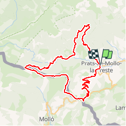
Tocht Mountainbike van 41 km beschikbaar op Occitanië, Pyrénées-Orientales, Prats-de-Mollo-la-Preste. Deze tocht wordt voorgesteld door tracegps.
Beschrijving
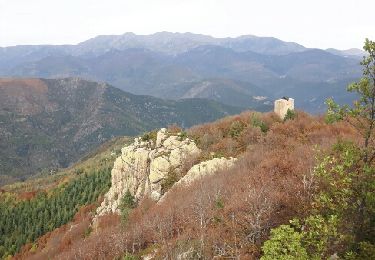
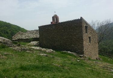
Espace VTT FFC Haut Vallespir - circuit n° 17 - Raid Transfrontalier. Circuit officiel labellisé par la Fédération Française de Cyclisme. Le circuit emblématique du site VTT. A la fois pour son coté « juge de paix » (tant au niveau physique que technique), pour son coté transfrontalier (11 km en ligne de crête coté Catalogne Sud) et pour son ambiance unique de haute montagne. Un véritable challenge à relever qui devra naturellement être réservé aux pratiquants sportifs de bon niveau. Les vététistes confirmés devront toutefois être très attentifs aux conditions météorologiques, la ligne de crête jusqu’au Col de Siern étant particulièrement exposée, en cas d’orage. Compte tenu de la longueur du parcours, il est utile de prendre en compte les différents échappatoires possibles : depuis le Col des Basses de Fabert retour par le circuit n°7 jusqu’à la Chapelle Ste-Marguerite. Ou bien, une fois arrivé à La Preste, rejoindre directement Prats-de-Mollo par la route, sans remonter dans le bassin de la Parcigoule. Ici, c’est la nature qui impose sa puissance.
Plaatsbepaling
Opmerkingen
Wandeltochten in de omgeving
![Tocht Stappen Prats-de-Mollo-la-Preste - Parts de Mollo - Photo](https://media.geolcdn.com/t/375/260/a323d879-2e3b-49e8-a319-14cd0114ee0f.jpg&format=jpg&maxdim=2)
![Stappen Stappen](https://static1.geolcdn.com/sitytour/trail-icons/101.png)
Stappen
![](/images/other/stat-length.png)
![](https://static1.geolcdn.com/siteimages/upload/files/16400158638029165_repeat_loop_refresh_sync_direction_icon.png)
![Tocht Stappen Prats-de-Mollo-la-Preste - col du miracle a pratiquement de mollo - Photo](https://media.geolcdn.com/t/375/260/7083b552-6fd4-47f6-9fb0-9d75c7868b46.jpg&format=jpg&maxdim=2)
![Stappen Stappen](https://static1.geolcdn.com/sitytour/trail-icons/101.png)
Stappen
![](/images/other/stat-length.png)
![](https://static1.geolcdn.com/siteimages/upload/files/16400158638029165_repeat_loop_refresh_sync_direction_icon.png)
![Tocht Stappen Le Tech - l,allau st guillem - Photo](https://media.geolcdn.com/t/375/260/1ac98370-8db2-4dc4-9697-e55bb3dbae72.jpg&format=jpg&maxdim=2)
![Stappen Stappen](https://static1.geolcdn.com/sitytour/trail-icons/101.png)
Stappen
![](/images/other/stat-length.png)
![](https://static1.geolcdn.com/siteimages/upload/files/16400158638029165_repeat_loop_refresh_sync_direction_icon.png)
![Tocht Stappen Le Tech - 3 - Photo](https://media.geolcdn.com/t/375/260/5a4186bc-56e6-4a8f-a98c-1862d1fc224e.jpg&format=jpg&maxdim=2)
![Stappen Stappen](https://static1.geolcdn.com/sitytour/trail-icons/101.png)
Stappen
![](/images/other/stat-length.png)
![](https://static1.geolcdn.com/siteimages/upload/files/16400158638029165_repeat_loop_refresh_sync_direction_icon.png)
![Tocht Stappen Molló - Tour de Mir (20/9/2018) - Photo](https://media.geolcdn.com/t/375/260/ef1914cd-274d-423f-8146-4fa054ce416c.jpg&format=jpg&maxdim=2)
![Stappen Stappen](https://static1.geolcdn.com/sitytour/trail-icons/101.png)
Stappen
![](/images/other/stat-length.png)
![](https://static1.geolcdn.com/siteimages/upload/files/16400158638029165_repeat_loop_refresh_sync_direction_icon.png)
![Tocht Stappen Lamanère - lamanere-coral_T - Photo](https://media.geolcdn.com/t/375/260/ext.jpg?maxdim=2&url=https%3A%2F%2Fservices.sitytrail.com%2FGeolivesWS%2FDownloadMedia.ashx%3FTrailID%3D796946%26Media%3D32ecc32a-7201-496c-b2f2-a04dfb66bd76.jpg)
![Stappen Stappen](https://static1.geolcdn.com/sitytour/trail-icons/101.png)
Stappen
![](/images/other/stat-length.png)
![](https://static1.geolcdn.com/siteimages/upload/files/16400158638029165_repeat_loop_refresh_sync_direction_icon.png)
![Tocht Stappen Lamanère - Lamanere_PuigDeComaNegra_T - Photo](https://media.geolcdn.com/t/375/260/ext.jpg?maxdim=2&url=https%3A%2F%2Fservices.sitytrail.com%2FGeolivesWS%2FDownloadMedia.ashx%3FTrailID%3D788626%26Media%3D47af7e63-d3c2-468b-9f31-16c9e5afa358.jpg)
![Stappen Stappen](https://static1.geolcdn.com/sitytour/trail-icons/101.png)
Stappen
![](/images/other/stat-length.png)
![](https://static1.geolcdn.com/siteimages/upload/files/16400158638029165_repeat_loop_refresh_sync_direction_icon.png)
![Tocht Stappen Lamanère - Tours de Cabrens - Photo](https://media.geolcdn.com/t/375/260/ext.jpg?maxdim=2&url=https%3A%2F%2Fservices.sitytrail.com%2FGeolivesWS%2FDownloadMedia.ashx%3FTrailID%3D655959%26Media%3Dfix__20161104114634.jpg)
![Stappen Stappen](https://static1.geolcdn.com/sitytour/trail-icons/101.png)
Stappen
![](/images/other/stat-length.png)
![](https://static1.geolcdn.com/siteimages/upload/files/16400158638029165_repeat_loop_refresh_sync_direction_icon.png)
![Tocht Stappen Le Tech - Col de la roue Saint Guilhem - Photo](https://media.geolcdn.com/t/375/260/ext.jpg?maxdim=2&url=https%3A%2F%2Fservices.sitytrail.com%2FGeolivesWS%2FDownloadMedia.ashx%3FTrailID%3D420946%26Media%3Dfix__20150514141536.jpg)
![Stappen Stappen](https://static1.geolcdn.com/sitytour/trail-icons/101.png)
Stappen
![](/images/other/stat-length.png)
![](https://static1.geolcdn.com/siteimages/upload/files/16400158638029165_repeat_loop_refresh_sync_direction_icon.png)