![](/images/other/stat-length.png)
![Tocht Mountainbike Corsavy - Espace VTT FFC Haut Vallespir - circuit n° 14 - Le tour de la Souque - Photo](https://media.geolcdn.com/t/1900/400/ext.pjpeg?maxdim=2&url=https%3A%2F%2Fservices.sitytrail.com%2FGeolivesWS%2FDownloadMedia.ashx%3FTrailID%3D104354%26Media%3D7594_2.jpg)
Espace VTT FFC Haut Vallespir - circuit n° 14 - Le tour de la Souque
tracegps
Gebruiker
![Lengte](/images/other/stat-length.png)
![Max. hoogte](https://static1.geolcdn.com/siteimages/upload/files/1508320355ic_sort_altitude_max_24dp.png)
![Positief hoogteverschil](https://static1.geolcdn.com/siteimages/upload/files/1508320355ic_sort_den_pos_24dp.png)
![Km-Effort](/images/other/stat-length.png)
![Min. hoogte](https://static1.geolcdn.com/siteimages/upload/files/1508320355ic_sort_altitude_min_24dp.png)
![Negatief hoogteverschil](https://static1.geolcdn.com/siteimages/upload/files/1508320355ic_sort_den_neg_24dp.png)
![Boucle](https://static1.geolcdn.com/siteimages/upload/files/16400158638029165_repeat_loop_refresh_sync_direction_icon.png)
![Mountainbike](https://static1.geolcdn.com/sitytour/trail-icons/202.png)
2h45
Moeilijkheid : Zeer moeilijk
![Scan deze QR-code om de tocht te openen in de SityTrail-applicatie](https://capi.geolives.com/qq0zvz2zws4bq2lad0pu/sitytour/trails/104354/qr.png?size=200)
Gratisgps-wandelapplicatie
Over ons
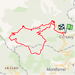
Tocht Mountainbike van 22 km beschikbaar op Occitanië, Pyrénées-Orientales, Corsavy. Deze tocht wordt voorgesteld door tracegps.
Beschrijving
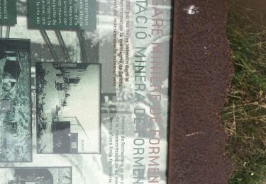
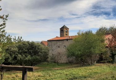
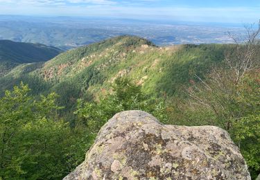
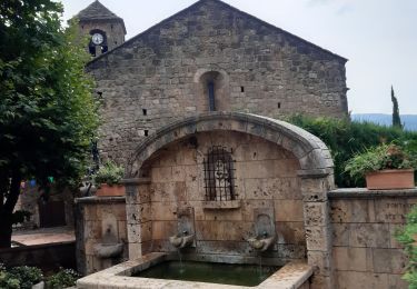
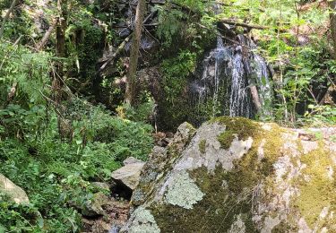
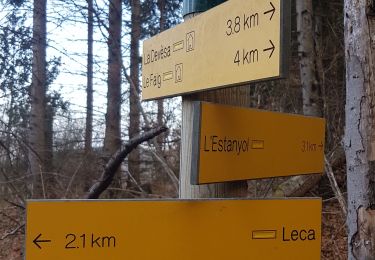
Espace VTT FFC Haut Vallespir - circuit n° 14 - Le tour de la Souque. Circuit officiel labellisé par la Fédération Française de Cyclisme. Cet itinéraire concentre tous les ingrédients de la pratique du VTT en montagne. Un gros dénivelé sur piste forestière, mais aussi des chemins moins roulant et plus nature, des passages en alpage, une longue descente très technique par un sentier à flanc de paroi et un final rapide grâce à un cheminement plus large. Ce tracé est réservé aux adeptes du VTT en quête d’itinéraires présentant un enjeu sportif et ludique. L’un des plus beaux itinéraires de moyenne montagne adossé au Massif du Canigou. Des paysages rares, sauvages et authentiques comme l’est l’histoire de ces hommes les Traginers d’abord, les mineurs de Batère ensuite qui peuplèrent et marquèrent à jamais cette montagne. Trois bonnes raisons de prolonger votre balade sur ce secteur. La découverte du gîte de Batère et de la tour du même nom, la table de Françoise à Corsavy à ne manquer sous aucun prétexte, et à Montferrer le diamant noir, le bien nommé, saura titiller vos papilles au bon goût de truffe. Bon appétit !!!
Plaatsbepaling
Opmerkingen
Wandeltochten in de omgeving
![Tocht Stappen Corsavy - Tour du Canigou - Photo](https://media.geolcdn.com/t/375/260/ext.jpg?maxdim=2&url=https%3A%2F%2Fstatic1.geolcdn.com%2Fsiteimages%2Fupload%2Ffiles%2F1553511878bg_sport_marche.png)
![Stappen Stappen](https://static1.geolcdn.com/sitytour/trail-icons/101.png)
Stappen
![](/images/other/stat-length.png)
![](https://static1.geolcdn.com/siteimages/upload/files/16400158638029165_repeat_loop_refresh_sync_direction_icon.png)
![Tocht Stappen Montbolo - Montbolo: du col dela reducta au col de Formentera - Photo](https://media.geolcdn.com/t/375/260/754853e5-7593-4cab-8eb6-e99d080b4823.jpg&format=jpg&maxdim=2)
![Stappen Stappen](https://static1.geolcdn.com/sitytour/trail-icons/101.png)
Stappen
![](/images/other/stat-length.png)
![](https://static1.geolcdn.com/siteimages/upload/files/16400158638029165_repeat_loop_refresh_sync_direction_icon.png)
![Tocht Stappen Montferrer - montferrer . El castel . Puiq de volafort .. retour par la piste - Photo](https://media.geolcdn.com/t/375/260/0038a41d-1b8d-49b6-87ad-9d0340b81119.jpg&format=jpg&maxdim=2)
![Stappen Stappen](https://static1.geolcdn.com/sitytour/trail-icons/101.png)
Stappen
![](/images/other/stat-length.png)
![](https://static1.geolcdn.com/siteimages/upload/files/16400158638029165_repeat_loop_refresh_sync_direction_icon.png)
![Tocht Stappen Montferrer - montferer - Photo](https://media.geolcdn.com/t/375/260/c8bf2bfd-54cc-4016-8546-91889da7514e.jpg&format=jpg&maxdim=2)
![Stappen Stappen](https://static1.geolcdn.com/sitytour/trail-icons/101.png)
Stappen
![](/images/other/stat-length.png)
![](https://static1.geolcdn.com/siteimages/upload/files/16400158638029165_repeat_loop_refresh_sync_direction_icon.png)
![Tocht Stappen Corsavy - 2022 TRANSPYRÉNÉENNE : refuge de Batere -Montalba - HOSTAL dels Traucayres - Photo](https://media.geolcdn.com/t/375/260/2dc3b86f-78ad-496e-bb51-5b658d77182b.jpg&format=jpg&maxdim=2)
![Stappen Stappen](https://static1.geolcdn.com/sitytour/trail-icons/101.png)
Stappen
![](/images/other/stat-length.png)
![](https://static1.geolcdn.com/siteimages/upload/files/16400158638029165_repeat_loop_refresh_sync_direction_icon.png)
![Tocht Stappen Montferrer - Montferrer . El Castel . Puig de Vilafort - retour par la piste - Photo](https://media.geolcdn.com/t/375/260/42383815-0ae2-4167-8591-fc1dd32f5296.jpg&format=jpg&maxdim=2)
![Stappen Stappen](https://static1.geolcdn.com/sitytour/trail-icons/101.png)
Stappen
![](/images/other/stat-length.png)
![](https://static1.geolcdn.com/siteimages/upload/files/16400158638029165_repeat_loop_refresh_sync_direction_icon.png)
![Tocht Stappen Le Tech - 3 - Photo](https://media.geolcdn.com/t/375/260/5a4186bc-56e6-4a8f-a98c-1862d1fc224e.jpg&format=jpg&maxdim=2)
![Stappen Stappen](https://static1.geolcdn.com/sitytour/trail-icons/101.png)
Stappen
![](/images/other/stat-length.png)
![](https://static1.geolcdn.com/siteimages/upload/files/16400158638029165_repeat_loop_refresh_sync_direction_icon.png)
![Tocht Stappen Corsavy - leca cabanes del faig14km 871m 4h45 - Photo](https://media.geolcdn.com/t/375/260/fa6fd1c5-d850-4de5-aa2f-243b4a5f6506.jpg&format=jpg&maxdim=2)
![Stappen Stappen](https://static1.geolcdn.com/sitytour/trail-icons/101.png)
Stappen
![](/images/other/stat-length.png)
![](https://static1.geolcdn.com/siteimages/upload/files/16400158638029165_repeat_loop_refresh_sync_direction_icon.png)
![Tocht Stappen Corsavy - mine de batere . puig d estella . tout batere - Photo](https://media.geolcdn.com/t/375/260/82163bcd-5237-4484-970b-12907d3c3ee6.jpg&format=jpg&maxdim=2)
![Stappen Stappen](https://static1.geolcdn.com/sitytour/trail-icons/101.png)
Stappen
![](/images/other/stat-length.png)
![](https://static1.geolcdn.com/siteimages/upload/files/16400158638029165_repeat_loop_refresh_sync_direction_icon.png)