![](/images/other/stat-length.png)
![Tocht Mountainbike Prades - Grande Traversée VTT FFC Ariège Pyrénées - Etape 2 - Refuge de la Chioula - Comus - Photo](https://media.geolcdn.com/t/1900/400/ext.pjpeg?maxdim=2&url=https%3A%2F%2Fservices.sitytrail.com%2FGeolivesWS%2FDownloadMedia.ashx%3FTrailID%3D104272%26Media%3D7478_3.jpg)
Grande Traversée VTT FFC Ariège Pyrénées - Etape 2 - Refuge de la Chioula - Comus
tracegps
Gebruiker
![Lengte](/images/other/stat-length.png)
![Max. hoogte](https://static1.geolcdn.com/siteimages/upload/files/1508320355ic_sort_altitude_max_24dp.png)
![Positief hoogteverschil](https://static1.geolcdn.com/siteimages/upload/files/1508320355ic_sort_den_pos_24dp.png)
![Km-Effort](/images/other/stat-length.png)
![Min. hoogte](https://static1.geolcdn.com/siteimages/upload/files/1508320355ic_sort_altitude_min_24dp.png)
![Negatief hoogteverschil](https://static1.geolcdn.com/siteimages/upload/files/1508320355ic_sort_den_neg_24dp.png)
![Boucle](https://static1.geolcdn.com/siteimages/upload/files/16400158638029165_repeat_loop_refresh_sync_direction_icon.png)
![Mountainbike](https://static1.geolcdn.com/sitytour/trail-icons/202.png)
2h00
Moeilijkheid : Moeilijk
![Scan deze QR-code om de tocht te openen in de SityTrail-applicatie](https://capi.geolives.com/qq0zvz2zws4bq2lad0pu/sitytour/trails/104272/qr.png?size=200)
Gratisgps-wandelapplicatie
Over ons
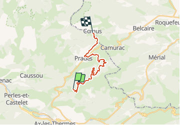
Tocht Mountainbike van 17,5 km beschikbaar op Occitanië, Ariège, Prades. Deze tocht wordt voorgesteld door tracegps.
Beschrijving
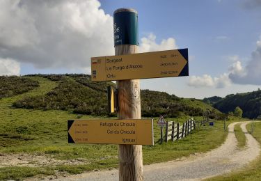
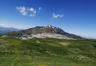
Grande Traversée VTT Ariège Pyrénées - Etape 2 - Refuge de la Chioula – Comus. Circuit labellisé par la Fédération Française de Cyclisme. Deuxième étape parfois difficile techniquement, mais moins physique que la précédente. De magnifiques panoramas sur le massif avant une bonne descente sur Montailloux et son château. Agence de Développement Touristique d'Ariège Pyrénées Route de Ganac – BP 30143 – 09004 Foix Cedex Tél : 05 61 02 30 70/fax : 05 61 65 17 34
Plaatsbepaling
Opmerkingen
Wandeltochten in de omgeving
![Tocht Stappen Sorgeat - Chemin des Bonhommes - Sorgeat Merens - Photo](https://media.geolcdn.com/t/375/260/ext.jpg?maxdim=2&url=https%3A%2F%2Fservices.sitytrail.com%2FGeolivesWS%2FDownloadMedia.ashx%3FTrailID%3D108179%26Media%3D769_1.jpg)
![Stappen Stappen](https://static1.geolcdn.com/sitytour/trail-icons/101.png)
Stappen
![](/images/other/stat-length.png)
![](https://static1.geolcdn.com/siteimages/upload/files/16400158638029165_repeat_loop_refresh_sync_direction_icon.png)
![Tocht Stappen Ax-les-Thermes - Lac de Campauleil - Orgeix - Photo](https://media.geolcdn.com/t/375/260/ext.jpg?maxdim=2&url=https%3A%2F%2Fstatic1.geolcdn.com%2Fsiteimages%2Fupload%2Ffiles%2F1553511878bg_sport_marche.png)
![Stappen Stappen](https://static1.geolcdn.com/sitytour/trail-icons/101.png)
Stappen
![](/images/other/stat-length.png)
![](https://static1.geolcdn.com/siteimages/upload/files/16400158638029165_repeat_loop_refresh_sync_direction_icon.png)
![Tocht Stappen Ignaux - Chioula d - Photo](https://media.geolcdn.com/t/375/260/7974ba69-0ab6-459b-b4ba-8e78a17f0143.jpg&format=jpg&maxdim=2)
![Stappen Stappen](https://static1.geolcdn.com/sitytour/trail-icons/101.png)
Stappen
![](/images/other/stat-length.png)
![](https://static1.geolcdn.com/siteimages/upload/files/16400158638029165_repeat_loop_refresh_sync_direction_icon.png)
![Tocht Stappen Prades - La Chioula Orlu GR107 le chemins des Bonshommes - Photo](https://media.geolcdn.com/t/375/260/f014250a-24ce-471f-839f-3ddca5e1db46.jpg&format=jpg&maxdim=2)
![Stappen Stappen](https://static1.geolcdn.com/sitytour/trail-icons/101.png)
Stappen
![](/images/other/stat-length.png)
![](https://static1.geolcdn.com/siteimages/upload/files/16400158638029165_repeat_loop_refresh_sync_direction_icon.png)
![Tocht Stappen Ax-les-Thermes - balade bleue au dessus d'Ax - Photo](https://media.geolcdn.com/t/375/260/1d43ecd2-3cc0-4fbb-b33b-15c49f564005.jpg&format=jpg&maxdim=2)
![Stappen Stappen](https://static1.geolcdn.com/sitytour/trail-icons/101.png)
Stappen
![](/images/other/stat-length.png)
![](https://static1.geolcdn.com/siteimages/upload/files/16400158638029165_repeat_loop_refresh_sync_direction_icon.png)
![Tocht Stappen Ax-les-Thermes - Orgeix _ Ignaux - Photo](https://media.geolcdn.com/t/375/260/e43b3995-af8e-4435-939e-d3db1e3b3da2.jpg&format=jpg&maxdim=2)
![Stappen Stappen](https://static1.geolcdn.com/sitytour/trail-icons/101.png)
Stappen
![](/images/other/stat-length.png)
![](https://static1.geolcdn.com/siteimages/upload/files/16400158638029165_repeat_loop_refresh_sync_direction_icon.png)
![Tocht Stappen Caussou - Le col de Marmare - Photo](https://media.geolcdn.com/t/375/260/77516022-b315-4aa7-a170-0ac26042a166.jpg&format=jpg&maxdim=2)
![Stappen Stappen](https://static1.geolcdn.com/sitytour/trail-icons/101.png)
Stappen
![](/images/other/stat-length.png)
![](https://static1.geolcdn.com/siteimages/upload/files/16400158638029165_repeat_loop_refresh_sync_direction_icon.png)
![Tocht Stappen Prades - Pic Fourcat Prades - Photo](https://media.geolcdn.com/t/375/260/7328a631-1f70-4385-b122-8064227fbc3d.jpg&format=jpg&maxdim=2)
![Stappen Stappen](https://static1.geolcdn.com/sitytour/trail-icons/101.png)
Stappen
![](/images/other/stat-length.png)
![](https://static1.geolcdn.com/siteimages/upload/files/16400158638029165_repeat_loop_refresh_sync_direction_icon.png)
![Tocht Te voet Ax-les-Thermes - GRP Ax-Orgeix - Photo](https://media.geolcdn.com/t/375/260/5f0b70a1-2609-4868-9e8d-7f819ac05a3a.jpeg&format=jpg&maxdim=2)
![Te voet Te voet](https://static1.geolcdn.com/sitytour/trail-icons/100.png)
Te voet
![](/images/other/stat-length.png)
![](https://static1.geolcdn.com/siteimages/upload/files/16400158638029165_repeat_loop_refresh_sync_direction_icon.png)