![](/images/other/stat-length.png)
![Tocht Mountainbike Savonnières - Raid Bibendum - Savonnières - Photo](https://media.geolcdn.com/t/1900/400/ext.pjpeg?maxdim=2&url=https%3A%2F%2Fstatic1.geolcdn.com%2Fsiteimages%2Fupload%2Ffiles%2F1524743154velo.jpg)
Raid Bibendum - Savonnières
tracegps
Gebruiker
![Lengte](/images/other/stat-length.png)
Lengte
63 km
![Max. hoogte](https://static1.geolcdn.com/siteimages/upload/files/1508320355ic_sort_altitude_max_24dp.png)
Max. hoogte
102 m
![Positief hoogteverschil](https://static1.geolcdn.com/siteimages/upload/files/1508320355ic_sort_den_pos_24dp.png)
Positief hoogteverschil
619 m
![Km-Effort](/images/other/stat-length.png)
Km-Effort
71 km
![Min. hoogte](https://static1.geolcdn.com/siteimages/upload/files/1508320355ic_sort_altitude_min_24dp.png)
Min. hoogte
37 m
![Negatief hoogteverschil](https://static1.geolcdn.com/siteimages/upload/files/1508320355ic_sort_den_neg_24dp.png)
Negatief hoogteverschil
618 m
![Boucle](https://static1.geolcdn.com/siteimages/upload/files/16400158638029165_repeat_loop_refresh_sync_direction_icon.png)
Boucle
Ja
Datum van aanmaak :
2014-12-10 00:00:00.0
Laatste wijziging :
2014-12-10 00:00:00.0
![Mountainbike](https://static1.geolcdn.com/sitytour/trail-icons/202.png)
3h30
Moeilijkheid : Medium
![Scan deze QR-code om de tocht te openen in de SityTrail-applicatie](https://capi.geolives.com/qq0zvz2zws4bq2lad0pu/sitytour/trails/104231/qr.png?size=200)
Gratisgps-wandelapplicatie
Over ons
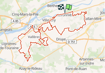
Tocht Mountainbike van 63 km beschikbaar op Centre-Val de Loire, Indre-et-Loire, Savonnières. Deze tocht wordt voorgesteld door tracegps.
Beschrijving
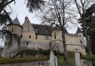
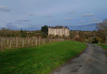
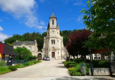
Départ de Savonnières, proche de Tours. Sponsorisée par Michelin. Rando assez calme sauf les 5 derniers km avec une pente terrible derrière le château de Villandry.
Plaatsbepaling
Land:
France
Regio :
Centre-Val de Loire
Departement/Provincie :
Indre-et-Loire
Gemeente :
Savonnières
Locatie:
Unknown
Vertrek:(Dec)
Vertrek:(UTM)
314821 ; 5246861 (31T) N.
Opmerkingen
Wandeltochten in de omgeving
![Stappen Stappen](https://static1.geolcdn.com/sitytour/trail-icons/101.png)
Villandry - 2015 05 24
Stappen
Gemakkelijk
(1)
Villandry,
Centre-Val de Loire,
Indre-et-Loire,
France
![](/images/other/stat-length.png)
4,9 km | 5,7 km-effort
1h 15min
![](https://static1.geolcdn.com/siteimages/upload/files/16400158638029165_repeat_loop_refresh_sync_direction_icon.png)
Ja
![Tocht Stappen Fondettes - Fondettes Vallières - Luynes Le Vieux-Bourg - 26.1km 360m 5h30 (45mn) - 2024 12 11 - Photo](https://media.geolcdn.com/t/375/260/7ea9ad8d-3a09-4814-97d4-258e1355629e.jpg&format=jpg&maxdim=2)
![Stappen Stappen](https://static1.geolcdn.com/sitytour/trail-icons/101.png)
Fondettes Vallières - Luynes Le Vieux-Bourg - 26.1km 360m 5h30 (45mn) - 2024 ...
Stappen
Medium
Fondettes,
Centre-Val de Loire,
Indre-et-Loire,
France
![](/images/other/stat-length.png)
26 km | 31 km-effort
5h 30min
![](https://static1.geolcdn.com/siteimages/upload/files/16400158638029165_repeat_loop_refresh_sync_direction_icon.png)
Ja
![Tocht Stappen Savonnières - Savonnières - Zig zag Villandry - 20.7km 260m 4h25 (40mn) - 2024 06 02 - Photo](https://media.geolcdn.com/t/375/260/12f64fcc-4f3e-4220-83eb-fe5365015280.jpg&format=jpg&maxdim=2)
![Stappen Stappen](https://static1.geolcdn.com/sitytour/trail-icons/101.png)
Savonnières - Zig zag Villandry - 20.7km 260m 4h25 (40mn) - 2024 06 02
Stappen
Gemakkelijk
Savonnières,
Centre-Val de Loire,
Indre-et-Loire,
France
![](/images/other/stat-length.png)
21 km | 24 km-effort
4h 25min
![](https://static1.geolcdn.com/siteimages/upload/files/16400158638029165_repeat_loop_refresh_sync_direction_icon.png)
Ja
![Tocht Stappen Ballan-Miré - Ballan-Miré - Parking des Châtaigniers - 8.4km 125m 1h50 - 2024 03 06 - Photo](https://media.geolcdn.com/t/375/260/1a378f68-cb26-4349-9743-c95ed818731a.jpg&format=jpg&maxdim=2)
![Stappen Stappen](https://static1.geolcdn.com/sitytour/trail-icons/101.png)
Ballan-Miré - Parking des Châtaigniers - 8.4km 125m 1h50 - 2024 03 06
Stappen
Medium
Ballan-Miré,
Centre-Val de Loire,
Indre-et-Loire,
France
![](/images/other/stat-length.png)
8,4 km | 10,1 km-effort
1h 50min
![](https://static1.geolcdn.com/siteimages/upload/files/16400158638029165_repeat_loop_refresh_sync_direction_icon.png)
Ja
![Tocht Stappen Saint-Étienne-de-Chigny - Saint-Étienne-de-Chigny - le Vieux Bourg - Luynes - 15.8km 285m 3h30 - 2024 02 28 - Photo](https://media.geolcdn.com/t/375/260/b6ad8ad7-2214-4d55-9cd7-2ee78c3b27ee.jpg&format=jpg&maxdim=2)
![Stappen Stappen](https://static1.geolcdn.com/sitytour/trail-icons/101.png)
Saint-Étienne-de-Chigny - le Vieux Bourg - Luynes - 15.8km 285m 3h30 - 2024 0...
Stappen
Medium
Saint-Étienne-de-Chigny,
Centre-Val de Loire,
Indre-et-Loire,
France
![](/images/other/stat-length.png)
15,8 km | 19,6 km-effort
3h 30min
![](https://static1.geolcdn.com/siteimages/upload/files/16400158638029165_repeat_loop_refresh_sync_direction_icon.png)
Ja
![Tocht Stappen Saint-Étienne-de-Chigny - Saint-Étienne-de-Chigny - la Pile de Cinq-Mars-la-Pile - 14.2km 215m 3h15 - 2024 02 17 - Photo](https://media.geolcdn.com/t/375/260/84d699f2-9fbc-4977-9839-f8db73d27f73.jpg&format=jpg&maxdim=2)
![Stappen Stappen](https://static1.geolcdn.com/sitytour/trail-icons/101.png)
Saint-Étienne-de-Chigny - la Pile de Cinq-Mars-la-Pile - 14.2km 215m 3h15 - 2...
Stappen
Medium
Saint-Étienne-de-Chigny,
Centre-Val de Loire,
Indre-et-Loire,
France
![](/images/other/stat-length.png)
14,5 km | 17,2 km-effort
3h 15min
![](https://static1.geolcdn.com/siteimages/upload/files/16400158638029165_repeat_loop_refresh_sync_direction_icon.png)
Ja
![Tocht Stappen Savonnières - Savonnières - les Fontaines GR3 et PRs - 20.1km 190m 4h40 - 2022 05 12 - Photo](https://media.geolcdn.com/t/375/260/58a53b1f-8878-4695-8af8-d5fb36baa215.jpg&format=jpg&maxdim=2)
![Stappen Stappen](https://static1.geolcdn.com/sitytour/trail-icons/101.png)
Savonnières - les Fontaines GR3 et PRs - 20.1km 190m 4h40 - 2022 05 12
Stappen
Gemakkelijk
Savonnières,
Centre-Val de Loire,
Indre-et-Loire,
France
![](/images/other/stat-length.png)
20 km | 23 km-effort
4h 40min
![](https://static1.geolcdn.com/siteimages/upload/files/16400158638029165_repeat_loop_refresh_sync_direction_icon.png)
Ja
![Tocht Stappen Berthenay - Berthenay - Sentier des deux Eaux - 16.3km 65m 4h00 - 2022 05 08 - Photo](https://media.geolcdn.com/t/375/260/0ed1278a-60ca-4774-800b-77548f464139.jpg&format=jpg&maxdim=2)
![Stappen Stappen](https://static1.geolcdn.com/sitytour/trail-icons/101.png)
Berthenay - Sentier des deux Eaux - 16.3km 65m 4h00 - 2022 05 08
Stappen
Gemakkelijk
Berthenay,
Centre-Val de Loire,
Indre-et-Loire,
France
![](/images/other/stat-length.png)
16,3 km | 17,2 km-effort
4h 0min
![](https://static1.geolcdn.com/siteimages/upload/files/16400158638029165_repeat_loop_refresh_sync_direction_icon.png)
Ja
![Tocht Stappen Saint-Étienne-de-Chigny - Saint-Étienne-de-Chigny - Pont de Bresme - 23.4km 275m 4h45 (25mn) - 2021 07 08 - Photo](https://media.geolcdn.com/t/375/260/99af599b-914a-4e89-a7d1-8d362555a6d7.jpg&format=jpg&maxdim=2)
![Stappen Stappen](https://static1.geolcdn.com/sitytour/trail-icons/101.png)
Saint-Étienne-de-Chigny - Pont de Bresme - 23.4km 275m 4h45 (25mn) - 2021 07 08
Stappen
Gemakkelijk
Saint-Étienne-de-Chigny,
Centre-Val de Loire,
Indre-et-Loire,
France
![](/images/other/stat-length.png)
23 km | 27 km-effort
4h 45min
![](https://static1.geolcdn.com/siteimages/upload/files/16400158638029165_repeat_loop_refresh_sync_direction_icon.png)
Ja