![](/images/other/stat-length.png)
![Tocht Mountainbike Arches - Espace VTT FFC Chemins du Coeur des Vosges - circuit n°32 - La Blanche Pierre - Photo](https://media.geolcdn.com/t/1900/400/ext.pjpeg?maxdim=2&url=https%3A%2F%2Fservices.sitytrail.com%2FGeolivesWS%2FDownloadMedia.ashx%3FTrailID%3D104184%26Media%3D7308_2.jpg)
Espace VTT FFC Chemins du Coeur des Vosges - circuit n°32 - La Blanche Pierre
tracegps
Gebruiker
![Lengte](/images/other/stat-length.png)
Lengte
5,6 km
![Max. hoogte](https://static1.geolcdn.com/siteimages/upload/files/1508320355ic_sort_altitude_max_24dp.png)
Max. hoogte
480 m
![Positief hoogteverschil](https://static1.geolcdn.com/siteimages/upload/files/1508320355ic_sort_den_pos_24dp.png)
Positief hoogteverschil
148 m
![Km-Effort](/images/other/stat-length.png)
Km-Effort
7,6 km
![Min. hoogte](https://static1.geolcdn.com/siteimages/upload/files/1508320355ic_sort_altitude_min_24dp.png)
Min. hoogte
363 m
![Negatief hoogteverschil](https://static1.geolcdn.com/siteimages/upload/files/1508320355ic_sort_den_neg_24dp.png)
Negatief hoogteverschil
148 m
![Boucle](https://static1.geolcdn.com/siteimages/upload/files/16400158638029165_repeat_loop_refresh_sync_direction_icon.png)
Boucle
Ja
Datum van aanmaak :
2014-12-10 00:00:00.0
Laatste wijziging :
2014-12-10 00:00:00.0
![Mountainbike](https://static1.geolcdn.com/sitytour/trail-icons/202.png)
25m
Moeilijkheid : Gemakkelijk
![Scan deze QR-code om de tocht te openen in de SityTrail-applicatie](https://capi.geolives.com/qq0zvz2zws4bq2lad0pu/sitytour/trails/104184/qr.png?size=200)
Gratisgps-wandelapplicatie
Over ons
Tocht Mountainbike van 5,6 km beschikbaar op Grand Est, Vogezen, Arches. Deze tocht wordt voorgesteld door tracegps.
Beschrijving
Espace VTT FFC Chemins du Cœur des Vosges - circuit n°32 - La Blanche Pierre Circuit officiel labellisé par la Fédération Française de Cyclisme. Parcours très facile vers la Côte de Vrupt et retour par le Bois de Rebaumont.
Plaatsbepaling
Land:
France
Regio :
Grand Est
Departement/Provincie :
Vogezen
Gemeente :
Arches
Locatie:
Unknown
Vertrek:(Dec)
Vertrek:(UTM)
316646 ; 5330839 (32U) N.
Opmerkingen
Wandeltochten in de omgeving
![Tocht Stappen Jarménil - haut jarmenil 2 - Photo](https://media.geolcdn.com/t/375/260/ext.jpg?maxdim=2&url=https%3A%2F%2Fstatic1.geolcdn.com%2Fsiteimages%2Fupload%2Ffiles%2F1553511878bg_sport_marche.png)
![Stappen Stappen](https://static1.geolcdn.com/sitytour/trail-icons/101.png)
haut jarmenil 2
Stappen
Medium
(1)
Jarménil,
Grand Est,
Vogezen,
France
![](/images/other/stat-length.png)
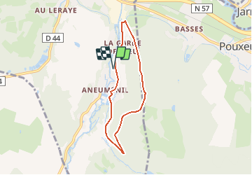
12,3 km | 16,8 km-effort
2h 39min
![](https://static1.geolcdn.com/siteimages/upload/files/16400158638029165_repeat_loop_refresh_sync_direction_icon.png)
Ja
![Tocht Stappen Hadol - hadol - Photo](https://media.geolcdn.com/t/375/260/ext.jpg?maxdim=2&url=https%3A%2F%2Fservices.sitytrail.com%2FGeolivesWS%2FDownloadMedia.ashx%3FTrailID%3D45357%26Media%3Dimage6.jpg)
![Stappen Stappen](https://static1.geolcdn.com/sitytour/trail-icons/101.png)
hadol
Stappen
Heel gemakkelijk
Hadol,
Grand Est,
Vogezen,
France
![](/images/other/stat-length.png)
11,3 km | 13,6 km-effort
Onbekend
![](https://static1.geolcdn.com/siteimages/upload/files/16400158638029165_repeat_loop_refresh_sync_direction_icon.png)
Ja
![Tocht Stappen Hadol - 2010-09-05 - 12h00m55 - Photo](https://media.geolcdn.com/t/375/260/ext.jpg?maxdim=2&url=https%3A%2F%2Fservices.sitytrail.com%2FGeolivesWS%2FDownloadMedia.ashx%3FTrailID%3D45319%26Media%3D20100905112812.jpg)
![Stappen Stappen](https://static1.geolcdn.com/sitytour/trail-icons/101.png)
2010-09-05 - 12h00m55
Stappen
Heel gemakkelijk
(1)
Hadol,
Grand Est,
Vogezen,
France
![](/images/other/stat-length.png)
11,3 km | 13,6 km-effort
Onbekend
![](https://static1.geolcdn.com/siteimages/upload/files/16400158638029165_repeat_loop_refresh_sync_direction_icon.png)
Ja
![Tocht Stappen Éloyes - Éloyes - Photo](https://media.geolcdn.com/t/375/260/a5ecf027-5eca-4a03-bdbf-2a468992ee9f.jpg&format=jpg&maxdim=2)
![Stappen Stappen](https://static1.geolcdn.com/sitytour/trail-icons/101.png)
![Tocht Stappen Pouxeux - Pouxeux - Photo](https://media.geolcdn.com/t/375/260/1c75fc37-d80a-4b9f-813d-14fb77a95e56.jpg&format=jpg&maxdim=2)
![Stappen Stappen](https://static1.geolcdn.com/sitytour/trail-icons/101.png)
![Tocht Stappen Pouxeux - St Nabord Malaide - Photo](https://media.geolcdn.com/t/375/260/dad164b5-eb60-4108-82a7-54c3b0f7cec1.jpg&format=jpg&maxdim=2)
![Stappen Stappen](https://static1.geolcdn.com/sitytour/trail-icons/101.png)
St Nabord Malaide
Stappen
Moeilijk
Pouxeux,
Grand Est,
Vogezen,
France
![](/images/other/stat-length.png)
11,2 km | 15 km-effort
3h 32min
![](https://static1.geolcdn.com/siteimages/upload/files/16400158638029165_repeat_loop_refresh_sync_direction_icon.png)
Ja
![Tocht Te voet Saint-Nabord - Sentier](https://media.geolcdn.com/t/375/260/ext.jpg?maxdim=2&url=https%3A%2F%2Fstatic1.geolcdn.com%2Fsiteimages%2Fupload%2Ffiles%2F1545311037marcheuse_200dpi.jpg)
![Te voet Te voet](https://static1.geolcdn.com/sitytour/trail-icons/100.png)
Sentier "La Grande Feigne"
Te voet
Gemakkelijk
(1)
Saint-Nabord,
Grand Est,
Vogezen,
France
![](/images/other/stat-length.png)
4,6 km | 5,9 km-effort
1h 19min
![](https://static1.geolcdn.com/siteimages/upload/files/16400158638029165_repeat_loop_refresh_sync_direction_icon.png)
Neen
![Tocht Te voet Raon-aux-Bois - Raon-aux-Bois - Variantes Circuit 3 - Photo](https://media.geolcdn.com/t/375/260/ext.jpg?maxdim=2&url=https%3A%2F%2Fstatic1.geolcdn.com%2Fsiteimages%2Fupload%2Ffiles%2F1545311037marcheuse_200dpi.jpg)
![Te voet Te voet](https://static1.geolcdn.com/sitytour/trail-icons/100.png)
Raon-aux-Bois - Variantes Circuit 3
Te voet
Gemakkelijk
Raon-aux-Bois,
Grand Est,
Vogezen,
France
![](/images/other/stat-length.png)
3,1 km | 4,5 km-effort
1h 1min
![](https://static1.geolcdn.com/siteimages/upload/files/16400158638029165_repeat_loop_refresh_sync_direction_icon.png)
Neen
![Tocht Stappen Arches - Arches Lamenil Dinoze Arches - Photo](https://media.geolcdn.com/t/375/260/291ee745-170b-4aa9-bcaa-30a0e7041915.jpg&format=jpg&maxdim=2)
![Stappen Stappen](https://static1.geolcdn.com/sitytour/trail-icons/101.png)
Arches Lamenil Dinoze Arches
Stappen
Medium
Arches,
Grand Est,
Vogezen,
France
![](/images/other/stat-length.png)
16,8 km | 22 km-effort
4h 0min
![](https://static1.geolcdn.com/siteimages/upload/files/16400158638029165_repeat_loop_refresh_sync_direction_icon.png)
Ja