![](/images/other/stat-length.png)
![Tocht Mountainbike Hadol - Espace VTT FFC Chemins du Coeur des Vosges - circuit n°26 - Le Pranzieux - Photo](https://media.geolcdn.com/t/1900/400/ext.pjpeg?maxdim=2&url=https%3A%2F%2Fservices.sitytrail.com%2FGeolivesWS%2FDownloadMedia.ashx%3FTrailID%3D104158%26Media%3D7263_1.jpg)
Espace VTT FFC Chemins du Coeur des Vosges - circuit n°26 - Le Pranzieux
tracegps
Gebruiker
![Lengte](/images/other/stat-length.png)
Lengte
14,1 km
![Max. hoogte](https://static1.geolcdn.com/siteimages/upload/files/1508320355ic_sort_altitude_max_24dp.png)
Max. hoogte
573 m
![Positief hoogteverschil](https://static1.geolcdn.com/siteimages/upload/files/1508320355ic_sort_den_pos_24dp.png)
Positief hoogteverschil
332 m
![Km-Effort](/images/other/stat-length.png)
Km-Effort
18,5 km
![Min. hoogte](https://static1.geolcdn.com/siteimages/upload/files/1508320355ic_sort_altitude_min_24dp.png)
Min. hoogte
396 m
![Negatief hoogteverschil](https://static1.geolcdn.com/siteimages/upload/files/1508320355ic_sort_den_neg_24dp.png)
Negatief hoogteverschil
332 m
![Boucle](https://static1.geolcdn.com/siteimages/upload/files/16400158638029165_repeat_loop_refresh_sync_direction_icon.png)
Boucle
Ja
Datum van aanmaak :
2014-12-10 00:00:00.0
Laatste wijziging :
2014-12-10 00:00:00.0
![Mountainbike](https://static1.geolcdn.com/sitytour/trail-icons/202.png)
45m
Moeilijkheid : Medium
![Scan deze QR-code om de tocht te openen in de SityTrail-applicatie](https://capi.geolives.com/qq0zvz2zws4bq2lad0pu/sitytour/trails/104158/qr.png?size=200)
Gratisgps-wandelapplicatie
Over ons
Tocht Mountainbike van 14,1 km beschikbaar op Grand Est, Vogezen, Hadol. Deze tocht wordt voorgesteld door tracegps.
Beschrijving
Espace VTT FFC Chemins du Cœur des Vosges - circuit n°26 - Le Pranzieux Circuit officiel labellisé par la Fédération Française de Cyclisme. Circuit facile au départ de Hadol pour une tour varié dans le Bois de la Moussate.
Plaatsbepaling
Land:
France
Regio :
Grand Est
Departement/Provincie :
Vogezen
Gemeente :
Hadol
Locatie:
Unknown
Vertrek:(Dec)
Vertrek:(UTM)
312027 ; 5328935 (32U) N.
Opmerkingen
Wandeltochten in de omgeving
![Tocht Te voet Raon-aux-Bois - Sentier](https://media.geolcdn.com/t/375/260/906ec9db-57ed-4e19-8504-e7673b4aefeb.jpeg&format=jpg&maxdim=2)
![Te voet Te voet](https://static1.geolcdn.com/sitytour/trail-icons/100.png)
Sentier "Raon-Aux-Bois"
Te voet
Medium
Raon-aux-Bois,
Grand Est,
Vogezen,
France
![](/images/other/stat-length.png)
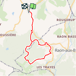
15,1 km | 21 km-effort
4h 42min
![](https://static1.geolcdn.com/siteimages/upload/files/16400158638029165_repeat_loop_refresh_sync_direction_icon.png)
Ja
![Tocht Te voet Raon-aux-Bois - Raon-aux-Bois - Circuit 3 - Photo](https://media.geolcdn.com/t/375/260/1915659e-2ae3-42c7-b754-84e2dc5c8a5e.jpeg&format=jpg&maxdim=2)
![Te voet Te voet](https://static1.geolcdn.com/sitytour/trail-icons/100.png)
Raon-aux-Bois - Circuit 3
Te voet
Medium
Raon-aux-Bois,
Grand Est,
Vogezen,
France
![](/images/other/stat-length.png)
14,8 km | 20 km-effort
4h 33min
![](https://static1.geolcdn.com/siteimages/upload/files/16400158638029165_repeat_loop_refresh_sync_direction_icon.png)
Ja
![Tocht Te voet Raon-aux-Bois - Raon-aux-Bois - Circuit 2 - Photo](https://media.geolcdn.com/t/375/260/1915659e-2ae3-42c7-b754-84e2dc5c8a5e.jpeg&format=jpg&maxdim=2)
![Te voet Te voet](https://static1.geolcdn.com/sitytour/trail-icons/100.png)
Raon-aux-Bois - Circuit 2
Te voet
Gemakkelijk
Raon-aux-Bois,
Grand Est,
Vogezen,
France
![](/images/other/stat-length.png)
11,1 km | 14,4 km-effort
3h 16min
![](https://static1.geolcdn.com/siteimages/upload/files/16400158638029165_repeat_loop_refresh_sync_direction_icon.png)
Ja
![Tocht Te voet Raon-aux-Bois - Raon-aux-Bois - Circuit 1 - Photo](https://media.geolcdn.com/t/375/260/1915659e-2ae3-42c7-b754-84e2dc5c8a5e.jpeg&format=jpg&maxdim=2)
![Te voet Te voet](https://static1.geolcdn.com/sitytour/trail-icons/100.png)
Raon-aux-Bois - Circuit 1
Te voet
Gemakkelijk
Raon-aux-Bois,
Grand Est,
Vogezen,
France
![](/images/other/stat-length.png)
14,2 km | 19,8 km-effort
4h 30min
![](https://static1.geolcdn.com/siteimages/upload/files/16400158638029165_repeat_loop_refresh_sync_direction_icon.png)
Ja
![Tocht Te voet Raon-aux-Bois - Sentier](https://media.geolcdn.com/t/375/260/906ec9db-57ed-4e19-8504-e7673b4aefeb.jpeg&format=jpg&maxdim=2)
![Te voet Te voet](https://static1.geolcdn.com/sitytour/trail-icons/100.png)
Sentier "Champée"
Te voet
Gemakkelijk
Raon-aux-Bois,
Grand Est,
Vogezen,
France
![](/images/other/stat-length.png)
4,6 km | 7,3 km-effort
1h 39min
![](https://static1.geolcdn.com/siteimages/upload/files/16400158638029165_repeat_loop_refresh_sync_direction_icon.png)
Neen
![Tocht Stappen Raon-aux-Bois - teleton - Photo](https://media.geolcdn.com/t/375/260/ext.jpg?maxdim=2&url=https%3A%2F%2Fstatic1.geolcdn.com%2Fsiteimages%2Fupload%2Ffiles%2F1553511878bg_sport_marche.png)
![Stappen Stappen](https://static1.geolcdn.com/sitytour/trail-icons/101.png)
teleton
Stappen
Medium
(1)
Raon-aux-Bois,
Grand Est,
Vogezen,
France
![](/images/other/stat-length.png)
10,9 km | 14,7 km-effort
2h 44min
![](https://static1.geolcdn.com/siteimages/upload/files/16400158638029165_repeat_loop_refresh_sync_direction_icon.png)
Ja
![Tocht Stappen Hadol - hadol - Photo](https://media.geolcdn.com/t/375/260/ext.jpg?maxdim=2&url=https%3A%2F%2Fservices.sitytrail.com%2FGeolivesWS%2FDownloadMedia.ashx%3FTrailID%3D45357%26Media%3Dimage6.jpg)
![Stappen Stappen](https://static1.geolcdn.com/sitytour/trail-icons/101.png)
hadol
Stappen
Heel gemakkelijk
Hadol,
Grand Est,
Vogezen,
France
![](/images/other/stat-length.png)
11,3 km | 13,6 km-effort
Onbekend
![](https://static1.geolcdn.com/siteimages/upload/files/16400158638029165_repeat_loop_refresh_sync_direction_icon.png)
Ja
![Tocht Stappen Hadol - 2010-09-05 - 12h00m55 - Photo](https://media.geolcdn.com/t/375/260/ext.jpg?maxdim=2&url=https%3A%2F%2Fservices.sitytrail.com%2FGeolivesWS%2FDownloadMedia.ashx%3FTrailID%3D45319%26Media%3D20100905112812.jpg)
![Stappen Stappen](https://static1.geolcdn.com/sitytour/trail-icons/101.png)
2010-09-05 - 12h00m55
Stappen
Heel gemakkelijk
(1)
Hadol,
Grand Est,
Vogezen,
France
![](/images/other/stat-length.png)
11,3 km | 13,6 km-effort
Onbekend
![](https://static1.geolcdn.com/siteimages/upload/files/16400158638029165_repeat_loop_refresh_sync_direction_icon.png)
Ja
![Tocht Stappen Raon-aux-Bois - Circuit Raon aux bois depuis parcours sportif - Photo](https://media.geolcdn.com/t/375/260/28555a57-7448-48fd-8ef7-a4f39e721b44.jpg&format=jpg&maxdim=2)
![Stappen Stappen](https://static1.geolcdn.com/sitytour/trail-icons/101.png)
Circuit Raon aux bois depuis parcours sportif
Stappen
Medium
Raon-aux-Bois,
Grand Est,
Vogezen,
France
![](/images/other/stat-length.png)
8,3 km | 11,1 km-effort
1h 56min
![](https://static1.geolcdn.com/siteimages/upload/files/16400158638029165_repeat_loop_refresh_sync_direction_icon.png)
Ja