![](/images/other/stat-length.png)
![Tocht Mountainbike Les Voivres - Espace VTT FFC Chemins du Coeur des Vosges - circuit n°1 - La Chèvre - Photo](https://media.geolcdn.com/t/1900/400/ext.pjpeg?maxdim=2&url=https%3A%2F%2Fservices.sitytrail.com%2FGeolivesWS%2FDownloadMedia.ashx%3FTrailID%3D104137%26Media%3D7215_1.jpg)
Espace VTT FFC Chemins du Coeur des Vosges - circuit n°1 - La Chèvre
tracegps
Gebruiker
![Lengte](/images/other/stat-length.png)
Lengte
10,2 km
![Max. hoogte](https://static1.geolcdn.com/siteimages/upload/files/1508320355ic_sort_altitude_max_24dp.png)
Max. hoogte
402 m
![Positief hoogteverschil](https://static1.geolcdn.com/siteimages/upload/files/1508320355ic_sort_den_pos_24dp.png)
Positief hoogteverschil
192 m
![Km-Effort](/images/other/stat-length.png)
Km-Effort
12,7 km
![Min. hoogte](https://static1.geolcdn.com/siteimages/upload/files/1508320355ic_sort_altitude_min_24dp.png)
Min. hoogte
316 m
![Negatief hoogteverschil](https://static1.geolcdn.com/siteimages/upload/files/1508320355ic_sort_den_neg_24dp.png)
Negatief hoogteverschil
195 m
![Boucle](https://static1.geolcdn.com/siteimages/upload/files/16400158638029165_repeat_loop_refresh_sync_direction_icon.png)
Boucle
Ja
Datum van aanmaak :
2014-12-10 00:00:00.0
Laatste wijziging :
2014-12-10 00:00:00.0
![Mountainbike](https://static1.geolcdn.com/sitytour/trail-icons/202.png)
1h00
Moeilijkheid : Gemakkelijk
![Scan deze QR-code om de tocht te openen in de SityTrail-applicatie](https://capi.geolives.com/qq0zvz2zws4bq2lad0pu/sitytour/trails/104137/qr.png?size=200)
Gratisgps-wandelapplicatie
Over ons
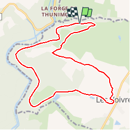
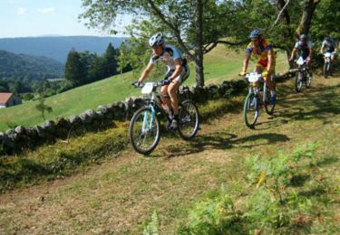
Tocht Mountainbike van 10,2 km beschikbaar op Grand Est, Vogezen, Les Voivres. Deze tocht wordt voorgesteld door tracegps.
Beschrijving
Espace VTT FFC Chemins du Cœur des Vosges - circuit n°1 - La Chèvre. Circuit officiel labellisé par la Fédération Française de Cyclisme. Au départ de la Forge de Thunimont et après les Voivres, traversée du Bois la Chèvre pour un circuit très facile.
Plaatsbepaling
Land:
France
Regio :
Grand Est
Departement/Provincie :
Vogezen
Gemeente :
Les Voivres
Locatie:
Unknown
Vertrek:(Dec)
Vertrek:(UTM)
297511 ; 5325246 (32U) N.
Opmerkingen
Wandeltochten in de omgeving
![Tocht Stappen Les Voivres - étang Lallemand - Photo](https://media.geolcdn.com/t/375/260/987fab5f-dd00-4df9-ad51-487dd6df9594.jpg&format=jpg&maxdim=2)
![Stappen Stappen](https://static1.geolcdn.com/sitytour/trail-icons/101.png)
étang Lallemand
Stappen
Medium
Les Voivres,
Grand Est,
Vogezen,
France
![](/images/other/stat-length.png)
8 km | 10,6 km-effort
2h 19min
![](https://static1.geolcdn.com/siteimages/upload/files/16400158638029165_repeat_loop_refresh_sync_direction_icon.png)
Ja
![Tocht Mountainbike La Chapelle-aux-Bois - Espace VTT FFC Chemins du Coeur des Vosges - circuit n°18 - Le Grand Bois - Photo](https://media.geolcdn.com/t/375/260/ext.jpg?maxdim=2&url=https%3A%2F%2Fservices.sitytrail.com%2FGeolivesWS%2FDownloadMedia.ashx%3FTrailID%3D104167%26Media%3D7278_2.jpg)
![Mountainbike Mountainbike](https://static1.geolcdn.com/sitytour/trail-icons/202.png)
Espace VTT FFC Chemins du Coeur des Vosges - circuit n°18 - Le Grand Bois
Mountainbike
Gemakkelijk
La Chapelle-aux-Bois,
Grand Est,
Vogezen,
France
![](/images/other/stat-length.png)
11,7 km | 14,5 km-effort
49min
![](https://static1.geolcdn.com/siteimages/upload/files/16400158638029165_repeat_loop_refresh_sync_direction_icon.png)
Ja
![Tocht Mountainbike La Haye - Espace VTT FFC Chemins du Coeur des Vosges - circuit n°13 - Les Chattis - Photo](https://media.geolcdn.com/t/375/260/ext.jpg?maxdim=2&url=https%3A%2F%2Fservices.sitytrail.com%2FGeolivesWS%2FDownloadMedia.ashx%3FTrailID%3D104163%26Media%3D7274_1.jpg)
![Mountainbike Mountainbike](https://static1.geolcdn.com/sitytour/trail-icons/202.png)
Espace VTT FFC Chemins du Coeur des Vosges - circuit n°13 - Les Chattis
Mountainbike
Medium
La Haye,
Grand Est,
Vogezen,
France
![](/images/other/stat-length.png)
10,7 km | 13,5 km-effort
45min
![](https://static1.geolcdn.com/siteimages/upload/files/16400158638029165_repeat_loop_refresh_sync_direction_icon.png)
Ja
![Tocht Mountainbike La Chapelle-aux-Bois - Espace VTT FFC Chemins du Coeur des Vosges - circuit n°19 - Le Rouge Moulin - Photo](https://media.geolcdn.com/t/375/260/ext.jpg?maxdim=2&url=https%3A%2F%2Fservices.sitytrail.com%2FGeolivesWS%2FDownloadMedia.ashx%3FTrailID%3D104155%26Media%3D7260_1.jpg)
![Mountainbike Mountainbike](https://static1.geolcdn.com/sitytour/trail-icons/202.png)
Espace VTT FFC Chemins du Coeur des Vosges - circuit n°19 - Le Rouge Moulin
Mountainbike
Moeilijk
La Chapelle-aux-Bois,
Grand Est,
Vogezen,
France
![](/images/other/stat-length.png)
26 km | 33 km-effort
2h 19min
![](https://static1.geolcdn.com/siteimages/upload/files/16400158638029165_repeat_loop_refresh_sync_direction_icon.png)
Ja
![Tocht Mountainbike Les Voivres - Espace VTT FFC Chemins du Coeur des Vosges - circuit n°2 - Les Chicottes - Photo](https://media.geolcdn.com/t/375/260/ext.jpg?maxdim=2&url=https%3A%2F%2Fservices.sitytrail.com%2FGeolivesWS%2FDownloadMedia.ashx%3FTrailID%3D104139%26Media%3D7220_1.jpg)
![Mountainbike Mountainbike](https://static1.geolcdn.com/sitytour/trail-icons/202.png)
Espace VTT FFC Chemins du Coeur des Vosges - circuit n°2 - Les Chicottes
Mountainbike
Moeilijk
Les Voivres,
Grand Est,
Vogezen,
France
![](/images/other/stat-length.png)
21 km | 27 km-effort
2h 0min
![](https://static1.geolcdn.com/siteimages/upload/files/16400158638029165_repeat_loop_refresh_sync_direction_icon.png)
Ja
![Tocht Mountainbike La Chapelle-aux-Bois - Espace VTT FFC Chemins du Coeur des Vosges - circuit n°20 - La Vierge des Neiges - Photo](https://media.geolcdn.com/t/375/260/ext.jpg?maxdim=2&url=https%3A%2F%2Fservices.sitytrail.com%2FGeolivesWS%2FDownloadMedia.ashx%3FTrailID%3D104121%26Media%3D7191_1.jpg)
![Mountainbike Mountainbike](https://static1.geolcdn.com/sitytour/trail-icons/202.png)
Espace VTT FFC Chemins du Coeur des Vosges - circuit n°20 - La Vierge des Neiges
Mountainbike
Moeilijk
La Chapelle-aux-Bois,
Grand Est,
Vogezen,
France
![](/images/other/stat-length.png)
17,3 km | 22 km-effort
1h 30min
![](https://static1.geolcdn.com/siteimages/upload/files/16400158638029165_repeat_loop_refresh_sync_direction_icon.png)
Ja
![Tocht 4x4 La Chapelle-aux-Bois - reco - Photo](https://media.geolcdn.com/t/375/260/ext.jpg?maxdim=2&url=https%3A%2F%2Fstatic1.geolcdn.com%2Fsiteimages%2Fupload%2Ffiles%2F15247431544x4.jpg)
![4x4 4x4](https://static1.geolcdn.com/sitytour/trail-icons/403.png)
![Tocht sport Les Voivres - Le Sentier des Pierres - Photo](https://media.geolcdn.com/t/375/260/ext.jpg?maxdim=2&url=https%3A%2F%2Fsecurestorage.geolives.com%2Fsitytour%2Ftrail-bg%2Fdefault.jpg)
Le Sentier des Pierres
sport
Heel gemakkelijk
(1)
Les Voivres,
Grand Est,
Vogezen,
France
![](/images/other/stat-length.png)
7,7 km | 10,2 km-effort
Onbekend
![](https://static1.geolcdn.com/siteimages/upload/files/16400158638029165_repeat_loop_refresh_sync_direction_icon.png)
Ja
![Tocht Stappen Les Voivres - étang L'allemand - Photo](https://media.geolcdn.com/t/375/260/3608b5ab-2570-4c96-83e4-f26a93f376e9.jpg&format=jpg&maxdim=2)
![Stappen Stappen](https://static1.geolcdn.com/sitytour/trail-icons/101.png)
étang L'allemand
Stappen
Gemakkelijk
Les Voivres,
Grand Est,
Vogezen,
France
![](/images/other/stat-length.png)
7,2 km | 8,7 km-effort
1h 38min
![](https://static1.geolcdn.com/siteimages/upload/files/16400158638029165_repeat_loop_refresh_sync_direction_icon.png)
Ja